Vernon
Yes
No
No
Fish and Aquatic Life
Overview
The South Fork of the Bad Axe River, located in southwestern Vernon County, flows in a westerly direction for approximately 18.5 miles before joining the North Fork to create the Bad Axe River. It has a slight gradient of 20 feet per mile and drains steep agricultural, pasture, and wooded land. The uppermost 1.5 miles is also known as South Bottom Creek, where a dry flood control dam traverses the stream. This structure allows normal stream flows through, but only temporarily impounds water during rain events then slowly releases it over time. A wet flood control structure which creates Sidie Hollow Lake is located just north of the dry dam on Coe Hollow and Sidie Hollow Creeks. Both structures were built in the 1960's to reduce the effects of flash flooding, common in the hilly terrain of the driftless area.
The South Fork Bad Axe River is a Class III trout stream for its entire length. The stretch of stream above the dry dam has minimal habitat for trout due to high flows during rain events.
Fish and habitat surveys, conducted between 1991 to 1994, documented a predominately sand bottom, varying abundance of aquatic vegetation and lack of undercut banks, all which provided little habitat for trout. Streambank erosion due to pasturing of livestock and high water during spring also decreased in-stream habitat quality. Brown and brook trout, smallmouth bass, pumpkinseed, burbot and a wide variety of forage fish were collected during these surveys. The reduction of streambank erosion caused by grazing livestock would improve in-stream habitat for the South Fork of the Bad Axe River fishery. The South Fork has been stocked by WDNR since 1960 with brown trout and occasionally brook trout, rainbow trout, largemouth bass, and smallmouth bass. Numerous road crossings provide access to the river.
From: Koperski, Cindy. 2002. The State of the Bad Axe - La Crosse River Basin. Wisconsin Department of Natural Resources, Madison, WI
Date 2002
Author Cynthia Koperski
Historical Description
Bad Axe River, South Fork, T12N, R7W, Section 12. Surface Acres = 43.7, Miles = 18.5, Gradient = 20.4 feet per m1le.
Flowing in a general westerly direction, this clear, hard water stream joins the North Fork south of Romance. That portion of the stream above the junction of Coe Hollow Creek and heading in Section 11 is sometimes known as South Bottom Creek. From Purdy upstream, the river is Class III brown trout watero The remainder of the South Fork is considered smallmouth bass water. Other fish species include sauger, white crappie, black bullhead, carp, and several minnow and other forage species. During the winter aerial groundwater survey, open water was observed from Purdy upstream to the junction of
Hornby Creek, and scattered open water areas from there upstream along the South Fork. Sand is the dominant bottom type, with some rubble and gravel along with small amounts of silt, boulder, clay, and detritus. Several road crossings provide access. Wildlife includes beaver, muskrat, and nesting mallards. teal, and wood ducks. Migrant diving and dabbler ducks also use the river.
From: Klick, Thomas A. and Threinen, C.W. 1973. Lake and Stream Classification Project. Surface Water Resources of Vernon County, Wisconsin Department of Natural Resources, Madison, WI.
Date 1973
Author Surface Water Inventory Of Wisconsin
General Condition
The South Fork of the Bad Axe River was assessed during the 2018 listing cycle; new biological (fish Index of Biotic Integrity (IBI) scores) sample data were clearly below the 2018 WisCALM listing thresholds for the Fish and Aquatic Life use. This water was meeting this designated use and was not considered impaired.
Date 2017
Author Ashley Beranek
Condition
Wisconsin has over 84,000 miles of streams, 15,000 lakes and milllions of acres of wetlands. Assessing the condition of this vast amount of water is challenging. The state's water monitoring program uses a media-based, cross-program approach to analyze water condition. An updated monitoring strategy (2015-2020) is now available. Compliance with Clean Water Act fishable, swimmable standards are located in the Executive Summary of Water Condition in 2018. See also the 'monitoring and projects' tab.
Reports
Recommendations
Control Streambank Erosion
The South Fork of the Bad Axe River fishery would benefit from the reduction of streambank erosion.
Management Goals
Wisconsin's Water Quality Standards provide qualitative and quantitative goals for waters that are protective of Fishable, Swimmable conditions [Learn more]. Waters that do not meet water quality standards are considered impaired and restoration actions are planned and carried out until the water is once again fishable and swimmable
Management goals can include creation or implementation of a Total Maximum Daily Load analysis, a Nine Key Element Plan, or other restoration work, education and outreach and more. If specific recommendations exist for this water, they will be displayed below online.
Monitoring
Monitoring the condition of a river, stream, or lake includes gathering physical, chemical, biological, and habitat data. Comprehensive studies often gather all these parameters in great detail, while lighter assessment events will involve sampling physical, chemical and biological data such as macroinvertebrates. Aquatic macroinvertebrates and fish communities integrate watershed or catchment condition, providing great insight into overall ecosystem health. Chemical and habitat parameters tell researchers more about human induced problems including contaminated runoff, point source dischargers, or habitat issues that foster or limit the potential of aquatic communities to thrive in a given area. Wisconsin's Water Monitoring Strategy was recenty updated.
Grants and Management Projects
Monitoring Projects
| WBIC | Official Waterbody Name | Station ID | Station Name | Earliest Fieldwork Date | Latest Fieldwork Date | View Station | View Data |
|---|
| 1639900 | South Fork Bad Axe | 10013803 | South Fork Bad Axe Station 1 - Kuehn Rd. Crossing Upstream | 5/14/1979 | 11/8/1979 | Map | Data |
| 1639900 | South Fork Bad Axe | 10013802 | South Fork Bad Axe at South Bottom Creek Station 3 - 1000 Ft. Downstream Of Bridge | | | Map | Data |
| 1639900 | South Fork Bad Axe | 10013811 | South Fork Bad Axe Station 9 - A Point In S17 Se 1/4 Se 1/4 | | | Map | Data |
| 1639900 | South Fork Bad Axe | 10013804 | South Fork Bad Axe Station 2 - Upstream Lockington Rd. Crossing | | | Map | Data |
| 1639900 | South Fork Bad Axe | 633172 | Bad Axe River South Fork - Mike Colburn Property | | | Map | Data |
| 1639900 | South Fork Bad Axe | 10013809 | South Fork Bad Axe Station 7 - Upstream Cth NN | 1/1/2015 | 1/1/2015 | Map | Data |
| 1639900 | South Fork Bad Axe | 10044155 | S Fork Bad Axe River - Bad Axe Rd. bridge | 7/13/2015 | 7/13/2015 | Map | Data |
| 1639900 | South Fork Bad Axe | 633070 | Bad Axe River South Fork - South Fork Bad Axe River | 8/8/1991 | 6/9/1992 | Map | Data |
| 1639900 | South Fork Bad Axe | 633044 | Bad Axe River South Fork - Kuehn Rd Sec7t12r6 | | | Map | Data |
| 1639900 | South Fork Bad Axe | 10013806 | South Fork Bad Axe Station 4 - Upstream Anderson Ridge Rd. Crossing | | | Map | Data |
| 1639900 | South Fork Bad Axe | 10013807 | South Fork Bad Axe Station 5 - Upstream Cth N | 4/23/2026 | 4/23/2026 | Map | Data |
| 1639900 | South Fork Bad Axe | 10013808 | South Fork Bad Axe Station 6 - A Point In The Sw 1/4 Sw 1/4 Of Section 24 | | | Map | Data |
| 1639900 | South Fork Bad Axe | 10052490 | South Fork Bad Axe River US Horby Creek Confluence | 5/22/2019 | 6/19/2026 | Map | Data |
| 1639900 | South Fork Bad Axe | 10022633 | South Fork Bad Axe River - Oliver Rd. | 1/1/2015 | 1/1/2015 | Map | Data |
| 1639900 | South Fork Bad Axe | 10013810 | South Fork Bad Axe Station 8 - Upstream Cth NN In S20 | 5/14/1979 | 1/1/2015 | Map | Data |
| 1639900 | South Fork Bad Axe | 10022634 | South Fork Bad Axe River - 210m Downstream Bad Axe Rd. | 1/1/2015 | 1/1/2015 | Map | Data |
| 1639900 | South Fork Bad Axe | 10058164 | SOUTH FORK BAD AXE - DRIVEWAY CROSSING BELOW ELLEFSON RD BRIDGE | | | Map | Data |
| 1639900 | South Fork Bad Axe | 10013812 | South Fork Bad Axe Station 10 - A Point In S9 Nw 1/4 Sw 1/4 | | | Map | Data |
| 1639900 | South Fork Bad Axe | 10022637 | South Fork Bad Axe River - Ellefson Rd. | 6/1/2002 | 1/1/2015 | Map | Data |
| 1639900 | South Fork Bad Axe | 10022636 | South Fork Bad Axe River - Farms Rd. Crossing On Danielson Property | 1/1/2015 | 1/1/2015 | Map | Data |
| 1639900 | South Fork Bad Axe | 10013805 | South Fork Bad Axe Station 3 - 300 Ft. Below Oliver Rd. Crossing | | | Map | Data |
| 1639900 | South Fork Bad Axe | 10013801 | South Fork Bad Axe at South Bottom Creek Station 2 - Upstream Side Of Dam At Outlet | | | Map | Data |
| 1639900 | South Fork Bad Axe | 633045 | South Fork Bad Axe River 1.5 mi S of Sidie Hollow Rd and Fredrickson Hill Rd | 6/4/2008 | 6/18/2009 | Map | Data |
| 1639900 | South Fork Bad Axe | 10013800 | South Fork Bad Axe at South Bottom Creek Station 1 - Mouth Upstream | | | Map | Data |
|
Watershed Characteristics
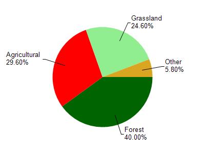
South Fork Bad Axe is located in the Bad Axe River watershed which is 195.49 mi². Land use in the watershed is primarily forest (40%), agricultural (29.60%) and a mix of grassland (24.60%) and other uses (5.80%). This watershed has 468.27 stream miles, 489.81 lake acres and 2,552.28 wetland acres.
Nonpoint Source Characteristics
This watershed is ranked High for runoff impacts on streams, Not Ranked for runoff impacts on lakes and Low for runoff impacts on groundwater and therefore has an overall rank of Low. This value can be used in ranking the watershed or individual waterbodies for grant funding under state and county programs.However, all waters are affected by diffuse pollutant sources regardless of initial water quality. Applications for specific runoff projects under state or county grant programs may be pursued. For more information, go to surface water program grants.