La Crosse
Yes
No
Yes
Fish and Aquatic Life
Overview
Gills Coulee is a five mile stream in central La Crosse County that flows
southeast before reaching the La Crosse River near West Salem, Wisconsin. It has a moderate gradient of 44.4 feet per mile and drains an area of
approximately 5.9 square miles. Gills Coulee is codified as a Class III coldwater trout stream from its mouth upstream for one mile, and as a Class II coldwater trout stream for the remaining length (Table A-2). The existing use for Gills Coulee is currently listed as warm water forage fishery. Land use in the watershed is dominated by upland forest with steep wooded hills and some lowland pasture and agricultural cropland. In many cases agricultural practices occur adjacent to the stream banks, causing immediate sediment runoff to the stream. This is especially evident during high precipitation or snowmelt events.
Habitat surveys dating back to 1972 note severe bank erosion caused by cattle access to the stream. The bank erosion that currently exists is likely a result of past agricultural practices, as more recent watershed surveys did not observe overgrazed pastures. Water chemistry data collected by
the La Crosse County Department of Land Conservation (LCD) was compiled and reviewed to characterize water quality conditions at several locations along the stream (Figure A-2). Data collected include grab samples for phosphorus, temperature, and dissolved oxygen, taken between the years of 2003 and 2005. Biological surveys were conducted by WDNR between the years of 1972 to 2004, and include habitat assessments, fish surveys, and macroinvertebrate surveys. (Appendix, Section A-3).
SOURCE ASSESSMENT
Point Sources- There are no point sources located on or discharging to Gills Coulee Creek.
Nonpoint Sources: Two methods were used to assess the nonpoint sources of sediment in the Gills Coulee watershed: the Natural Resources Conservation Service (NRCS) Streambank Erosion Calculation method, and the Revised Universal Soil Loss Equation 2 (RUSLE2).
The total existing sediment load contributed to Gill Coulee from streambank
erosion is estimated to be 7.1 tons per day. This is an underestimate of what
actual erosion rates may be currently because some severely eroded sections
assigned rates of 0.5+ feet/year were calculated at a rate of 0.5 feet/year but may in fact be receding at a higher rate.
Date 2004
Author Aquatic Biologist
Historical Description
Gills Coulee Creek, located in central La Crosse County, flows for approximately three miles in a southerly direction before reaching the La Crosse River. It has a gradient of 44 feet per mile and drains agricultural valley land with some steep wooded hills. Gills Coulee Creek is a Class III trout stream from the mouth upstream for one mile, then Class two for the remaining upstream miles.
Only forage fish, green sunfish, and northern pike were documented in a 1993 fish survey. Heavy bank erosion due to cattle access, lack of in-stream cover, and a predominantly silt and sand bottom are largely contributing to problems seen in this stream. Consequently, Gills Coulee Creek is listed as an impaired water of the state. (see discussion on Wisconsin impaired waters in Chapter 3 or at www.dnr.state.wi.us/org/water/wm/wqs/303d/) The stream was stocked with brook trout by the WDNR until 1996. Access to Gills Coulee Creek is from six bridge crossings.
Water chemistry testing of streams throughout La Crosse County was initiated by the La Crosse County Land Conservation Department in 1998. Baseflow conditions were targeted for testing as the most likely to show normal water quality conditions. Sampling takes place four times annually when no rainfall or snowmelt has occurred during the previous 72 hours. Between 1998 and 2001, Gills Coulee Creek never met the county phosphorus goal and met the county fecal coliform bacteria goal in only 20% of the samples taken. These data indicate a nutrient load that is likely also contributing to high bacterial counts. The county ranks Gills Coulee Creek the second highest priority stream on which to expend effort to reduce phosphorus and bacterial contamination. La Crosse County should continue baseflow sampling of Gills Coulee Creek to determine water quality trends. If the La Crosse County Land Conservation Department installs streambank stabilization and/or barnyard runoff control measures along Gills Coulee Creek, a fish and habitat survey should be conducted to determine if the stream has improved.
Date 2002
Author Aquatic Biologist
Facilities Management
There are no point sources located on or discharging to Gills Coulee Creek.
Date 2014
Author James Amrhein
General Condition
Gills Coulee is a five mile stream in central La Crosse County that flows
southeast before reaching the La Crosse River near West Salem, Wisconsin. It has a moderate gradient of 44.4 feet per mile and drains an area of
approximately 5.9 square miles. Gills Coulee is codified as a Class III cold water trout stream from its mouth upstream for one mile, and as a Class II cold water trout stream for the remaining length (Table A-2). The existing use for Gills Coulee is currently listed as warm water forage fishery.
Land use in the watershed is dominated by upland forest with steep wooded hills and some lowland pasture and agricultural cropland (Table 2). In many
cases agricultural practices occur adjacent to the stream banks, causing immediate sediment runoff to the stream. This is especially evident during high
precipitation or snowmelt events.
Habitat surveys dating back to 1972 note severe bank erosion caused by cattle access to the stream. The bank erosion that currently exists is likely a result of past agricultural practices, as more recent watershed surveys did not observe overgrazed pastures. Water chemistry data collected by
the La Crosse County Department of Land Conservation (LCD) was compiled
and reviewed to characterize water quality conditions at several locations along the stream (Figure A-2). Data collected include grab samples for phosphorus, temperature, and dissolved oxygen, taken between the years of 2003 and 2005.
Biological surveys were conducted by WDNR between the years of 1972 to 2004, and include habitat assessments, fish surveys, and macroinvertebrate surveys.
Date 2011
Author James Amrhein
General Condition
Gills Coulee Creek is a 5-mile long stream in La Crosse County that flows directly to the La Crossed River. It appears to be in a separate 12-digit HUC than Adams Valley Creek. It has an approved TMDL. Funds from a TRM grant, funds from DATCP and EQIP funds were used to stabilize streambanks in an upper portion of the watershed. A second TRM grant has been awarded. Cindy Koperski needs to be contacted for more information. Jim Baumann, Dec. 2007.
Date 2007
Author Cynthia Koperski
Impaired Waters
Two methods were used to assess the nonpoint sources of sediment in the Gills Coulee watershed: the Natural Resources Conservation Service (NRCS) Stream bank Erosion Calculation method, and the Revised Universal Soil
Loss Equation 2 (RUSLE2). The total sediment load generated from stream bank erosion was calculated by determining eroding area, lateral recession rate, and dry density of the soil. Eroding streambank lengths were geolocated using GPS, and corresponding bank heights were measured. Lateral recession rate was determined by assessing digital photography of the measured stream sections and best professional judgment. Dry soil
densities used in the calculations were 100 pounds per cubic foot, the average value for silt loam and sandy loam. Silt loam and sandy loam
were determined to be the dominant soil types along the stream, according to the NRCS State Soil Geographic (STATSGO) database. Erosion (lbs/yr) was calculated for each landowner by multiplying average annual lateral recession rate, eroding area, and soil bulk density. Existing and target erosion
values for each landowner are outlined in Tables B-1 and B-2.
The total existing sediment load contributed to Gill Coulee from stream bank
erosion is estimated to be 7.1 tons per day. This is an underestimate of what
actual erosion rates may be currently because some severely eroded sections
assigned rates of 0.5+ feet/year were calculated at a rate of 0.5 feet/year but may in fact be receding at a higher rate. The target sediment load for eroding stream banks is 0.78 tons per day. Target recession rates were set at 0.05, which falls in the upper end of the NRCS �Slight� erosion category. This category includes �some bare bank but active erosion not readily apparent�some rills but no vegetative overhang�no exposed tree roots�. It is expected that once stream banks are stabilized, there will be some naturally occurring erosion and a 0.05 recession rate reflects a reasonable target to achieve and is consistent with a stable bank.
Date
Author James Amrhein
Condition
Wisconsin has over 84,000 miles of streams, 15,000 lakes and milllions of acres of wetlands. Assessing the condition of this vast amount of water is challenging. The state's water monitoring program uses a media-based, cross-program approach to analyze water condition. An updated monitoring strategy (2015-2020) is now available. Compliance with Clean Water Act fishable, swimmable standards are located in the Executive Summary of Water Condition in 2018. See also the 'monitoring and projects' tab.
Reports
Recommendations
Control Streambank Erosion
Grade stabilization project. Due to excessive sedimentation, Gills Coulee Creek is currently not meeting applicable narrative water quality criterion as defined in NR 102.04 (1). Excessive sedimentation is considered an objectionable deposit.
In addition, Gills Coulee is currently listed as a warm water forage fishery and is not supporting its codified use as a coldwater fish community.
Protect Riparian or Shorelands
Streambank & shoreline protection for Gills Coulee Creek which is a tributary to the La Crosse River, located in La Crosse County in west central Wisconsin.
TMDL Implementation
Gills Coulee Creek is a tributary to the La Crosse River, located in La Crosse County in west central Wisconsin. The Wisconsin Department of Natural Resources (WDNR) placed Gills Coulee Creek on the state's 303(d) impaired waters list due to degraded in-stream habitat from excessive sedimentation. The Clean Water Act and USEPA regulations require each state develop Total Maximum Daily Loads (TMDLs) for waters on the Section 303(d) impaired waters list. The purpose of the TMDL is to identify load allocations and management actions that will help restore the biological integrity of the stream.
TMDL Implementation
Gills Coulee is a five mile stream in central La Crosse County that flows southeast before reaching the La Crosse River near West Salem, Wisconsin. It has a moderate gradient of 44.4 feet per mile and drains an area of approximately 5.9 square miles. Gills Coulee is codified as a Class III coldwater. The TMDL is in implementation. trout stream from its mouth upstream for one mile, and as a Class II coldwater trout stream for the remaining length (Table A-2). The existing use for Gills Coulee is currently listed as warm water forage fishery.
Implementation Plan is needed.
TMDL Development
TMDL Development for Gills Coulee Creek (1652300) in La Crosse County, WI. Gills Coulee is a five mile stream in central La Crosse County that flows
southeast before reaching the La Crosse River near West Salem, Wisconsin. The Wisconsin Department of Natural Resources (WDNR) placed Gills Coulee Creek on the state�s 303(d) impaired waters list due to degraded in-stream habitat from excessive sedimentation.
TMDL (USEPA) Approved
Gills Coulee is a five mile stream in central La Crosse County that flows
southeast before reaching the La Crosse River near West Salem, Wisconsin. It has a moderate gradient of 44.4 feet per mile and drains an area of approximately 5.9 square miles. Gills Coulee is codified as a Class III coldwater. The TMDL is in implementation.
trout stream from its mouth upstream for one mile, and as a Class II coldwater
trout stream for the remaining length (Table A-2). The
existing use for Gills Coulee is currently listed as warm
water forage fishery (Table A-1).
Management Goals
Wisconsin's Water Quality Standards provide qualitative and quantitative goals for waters that are protective of Fishable, Swimmable conditions [Learn more]. Waters that do not meet water quality standards are considered impaired and restoration actions are planned and carried out until the water is once again fishable and swimmable
Management goals can include creation or implementation of a Total Maximum Daily Load analysis, a Nine Key Element Plan, or other restoration work, education and outreach and more. If specific recommendations exist for this water, they will be displayed below online.
Monitoring
Monitoring the condition of a river, stream, or lake includes gathering physical, chemical, biological, and habitat data. Comprehensive studies often gather all these parameters in great detail, while lighter assessment events will involve sampling physical, chemical and biological data such as macroinvertebrates. Aquatic macroinvertebrates and fish communities integrate watershed or catchment condition, providing great insight into overall ecosystem health. Chemical and habitat parameters tell researchers more about human induced problems including contaminated runoff, point source dischargers, or habitat issues that foster or limit the potential of aquatic communities to thrive in a given area. Wisconsin's Water Monitoring Strategy was recenty updated.
Grants and Management Projects
Monitoring Projects
| WBIC | Official Waterbody Name | Station ID | Station Name | Earliest Fieldwork Date | Latest Fieldwork Date | View Station | View Data |
|---|
| 1652300 | Gill Coulee Creek | 10011208 | Gill Coulee Creek - Gill Coulee Station #1 25m Upstream From Downstream Bridge at Fenceline Gills Coulee Rd. | 11/23/2020 | 8/6/2025 | Map | Data |
| 1652300 | Gill Coulee Creek | 10013962 | Gills Coulee Creek Station 1 - 690ft Upstream Of Lowermost Gills Coulee Rd. Bridge Crossing In S32 | | | Map | Data |
| 1652300 | Gill Coulee Creek | 10013953 | Gills Coulee Creek Station 2 - T17n R6w S32 Ne 1/4 Sw 1/4 | | | Map | Data |
|
Monitoring Studies
The WDNR intends to monitor Gills Coulee Creek based on the rate of
implementation of the TMDL, including the sites where implementations of
Targeted Runoff Management (TRM) grants are aimed at removing the stream from the impaired waters list. Monitoring will continue until it is deemed that the stream has responded to the point where it is meeting its codified use or until funding for these studies are discontinued. In addition, the stream will be monitored on a 5 to 6 year interval as part of a baseline monitoring strategy to assess temporary conditions and note trends in overall stream quality. The monitoring will consist of metrics contained in WDNR�s baseline protocol for wadeable streams, such as the Index of Biotic Integrity (IBI), the Hilsenhoff Biotic Index (HBI), the current habitat assessment tool, and sampling of water quality parameters at a subset of sites.
Date 2014
Author James Amrhein
Watershed Characteristics
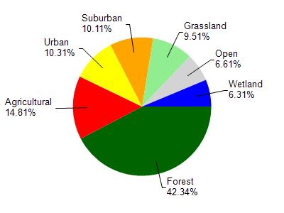
Gill Coulee Creek is located in the Lower La Crosse River watershed which is 145.46 mi². Land use in the watershed is primarily forest (42.30%), agricultural (14.80%) and a mix of urban (10.30%) and other uses (32.50%). This watershed has 295.20 stream miles, 1,187.12 lake acres and 5,641.64 wetland acres.
Nonpoint Source Characteristics
This watershed is ranked Medium for runoff impacts on streams, Not Ranked for runoff impacts on lakes and Low for runoff impacts on groundwater and therefore has an overall rank of Low. This value can be used in ranking the watershed or individual waterbodies for grant funding under state and county programs.However, all waters are affected by diffuse pollutant sources regardless of initial water quality. Applications for specific runoff projects under state or county grant programs may be pursued. For more information, go to surface water program grants.
Gills Coulee Creek is considered a Cool-Cold Mainstem, Cool-Cold Headwater under the state's Natural Community Determinations.
Natural communities (stream and lake natural communities) represent model results and DNR staff valiation processes that confirm or update predicted conditions based on flow and temperature modeling from historic and current landscape features and related variables. Predicated flow and temperatures for waters are associated predicated fish assemblages (communities). Biologists evaluate the model results against current survey data to determine if the modeled results are corect and whether biological indicators show water quaity degradation. This analysis is a core component of the state's resource management framework. Wisconsin's Riverine Natural Communities.
Cool (Cold-Transition) Mainstem streams are moderate-to-large but still wadeable perennial streams with cold to cool summer temperatures. Coldwater fishes are common to uncommon, transitional fishes are abundant to common, and warm water fishes are uncommon to absent. Headwater species are common to absent,
mainstem species are abundant to common, and river species are common to absent.
Cool (Cold-Transition) Headwaters are small, usually perennial streams with cold to cool summer temperatures. Coldwater fishes are common to uncommon (<10 per 100 m), transitional fishes are abundant to common, and warm water fishes are uncommon to absent. Headwater species are abundant to common, mainstem species are common to absent, and river species are absent.
From the La Crosse River to the west line of section 23 (class 3 Trout water);
From the west line of section 23 to the headwaters (class 2 Trout water).
Date 1980
Author Aquatic Biologist