Clark, Jackson
No
No
Yes
Fish and Aquatic Life
Overview
This impoundment on the Black River is an intensively used recreational resource in Jackson and Clark counties. Both counties maintain parks on its shores and public access to the lake. Lake Arbutus has a surface area of 839 acres, with an average depth of 16 feet and maximum depth of 50 feet. A consumption advisory for mercury contamination exists for most game fish (WDNR, 1997). Additional representative fish species should be collected for contaminant analysis to update the advisory database and track mercury concentration trends (Amrhein). Due to the fish advisory, Lake Arbutus is on the 1998 Wisconsin impaired waters (303(d)) list provided to the United States Environmental Protection Agency.
Many homes border the lake, some of which have illegal structures too near the shoreline. The county zoning administrators of Jackson and Clark counties are responsible for enforcing shoreland zoning. WDNR staff should support county staff in enforcement of existing county ordinances and education of lakefront landowners of the need and importance of shoreland zoning.
As part of the Federal Energy Regulatory Commission (FERC) license requirements for the dam at Lake Arbutus, extensive water quality testing was conducted in 1991. Macrophyte communities appeared to be severely limited due to the substrate and stained water, which reduces light penetration. The fishery is dominated by walleye, but musky, bass, northern pike, channel catfish, yellow perch, rock bass, and black crappie are also present in the lake (Midwest Hydraulic Company).
There have been occasional complaints of excessive algal growth in Lake Arbutus over the past several years. Water quality monitoring was conducted biweekly in Lake Arbutus from May 15, 1997 through October 1, 1997 to assess in lake water quality conditions. Water quality monitoring indicated the lake has extremely high nutrient levels. Due to the water being highly colored and near normal flows in the Black River, algal levels were moderate in 1997. The low retention time may be a reason why there are fewer nuisance algal blooms in Lake Arbutus as compared to other impoundments. Nutrient monitoring was also conducted in the Black River at Neillsville and the East Fork of the Black River near the lake. The lake water quality data and tributary stream data can be utilized to predict under what conditions algal growth would become excessive in Lake Arbutus.
Date 1999
Author Aquatic Biologist
Historical Description
Arbutus Lake is a soft water, drainage impoundment on the Black River in Clark and Jackson Counties. The dam has a 92-foot head and is owned by the Northern States Power Company. The water is slightly acid, has a medium brown color, and a low transparency. Muskellunge, northern pike, walleye, largemouth bass, smallmouth bass, channel catfish, bluegill, pumpkinseed, rock bass, black crappie, white crappie, yellow perch, sticker, and redhorse make up the fishery. Although present, carp are not a management problem. Recreational areas, including picnicking, camping, swimming, and boat launching sites, are provided by Clark and Jackson Counties who have leased lands from the Northern States Power Company. Clark County owns frontage along the Arnold Creek arm of the flowage. There are seven resorts, about 95 private dwellings, and a Boy Scout Camp located on the shores. During the migratory seasons, swans, geese, clucks (dabblers and divers), and coot may be found on the impoundment and hunters take advantage of this during the fall season.
Source: 1965, Surface Water Resources of Clark County Arbutus Lake T23N, R3W, S36 Surface Acres = 821, S.D.F. = 3.24, Known Maximum Depth = 56 feet.
Date 1965
Author Aquatic Biologist
Impaired Waters
Arbutus Lake was recently evaluated during the ten-year period of 2009 through 2018 for results that were reported to the USEPA for the 2020 Clean Water Act condition report. The waterbody is considered impaired, or in poor condition for designated uses which include the quality of fish and aquatic life, recreational use, and public health and welfare (fish consumption and related). Pollutants or problems encountered during sampling (impairments) are determined based on water quality standards outlined in Wisconsin 2020 Consolidated Assessment and Listing Methodology (WisCALM). Assessment results show water conditions that are potentially harmful for Aquatic Life and Recreation uses due to values for total phosphorus and chlorophyll that fall into the range expected for an aquatic community in poor health, therefore this water is listed as impaired.
Assessment results during the 2020 listing cycle show total phosphorus chlorophyll levels that indicate impairment to Aquatic Life and Recreation uses, according to 2020 WisCALM standards. Based on the most updated information, the impairments of eutrophication and excess algal growth were added to the total phosphorus listing for this water in 2020.
Date 2019
Author Ashley Beranek
Condition
Wisconsin has over 84,000 miles of streams, 15,000 lakes and milllions of acres of wetlands. Assessing the condition of this vast amount of water is challenging. The state's water monitoring program uses a media-based, cross-program approach to analyze water condition. An updated monitoring strategy (2015-2020) is now available. Compliance with Clean Water Act fishable, swimmable standards are located in the Executive Summary of Water Condition in 2018. See also the 'monitoring and projects' tab.
Reports
Recommendations
Monitor or Propose 303(d) Listing
Chemistry samples for total phosphorus and Chlorophyll a will be collected in Lake Arbutus to determine if current in-lake conditions meet water quality standards and to verify, per WisCALM guidance, whether 303(d) listing is appropriate for this lake. This project will fund the first of two years of sampling.
Management Goals
Wisconsin's Water Quality Standards provide qualitative and quantitative goals for waters that are protective of Fishable, Swimmable conditions [Learn more]. Waters that do not meet water quality standards are considered impaired and restoration actions are planned and carried out until the water is once again fishable and swimmable
Management goals can include creation or implementation of a Total Maximum Daily Load analysis, a Nine Key Element Plan, or other restoration work, education and outreach and more. If specific recommendations exist for this water, they will be displayed below online.
Monitoring
Monitoring the condition of a river, stream, or lake includes gathering physical, chemical, biological, and habitat data. Comprehensive studies often gather all these parameters in great detail, while lighter assessment events will involve sampling physical, chemical and biological data such as macroinvertebrates. Aquatic macroinvertebrates and fish communities integrate watershed or catchment condition, providing great insight into overall ecosystem health. Chemical and habitat parameters tell researchers more about human induced problems including contaminated runoff, point source dischargers, or habitat issues that foster or limit the potential of aquatic communities to thrive in a given area. Wisconsin's Water Monitoring Strategy was recenty updated.
Grants and Management Projects
Monitoring Projects
| WBIC | Official Waterbody Name | Station ID | Station Name | Earliest Fieldwork Date | Latest Fieldwork Date | View Station | View Data |
|---|
| 1727800 | Arnold Creek | 10030958 | Arnold Creek -- North Arnold Creek Access | 5/28/2012 | 8/20/2022 | Map | Data |
| 1727700 | Arbutus Lake* | 990103 | Lake Arbutus - Lake Arbutus at Arnold Creek | | | Map | Data |
| 1727700 | Arbutus Lake* | 10018406 | Lake Arbutus -- Access Nr Klima Rd | 10/6/2004 | 7/16/2025 | Map | Data |
| 1727700 | Arbutus Lake* | 10007629 | Lake Arbutus at East Arbutus County Park Beach | 6/30/2003 | 7/28/2025 | Map | Data |
| 1727700 | Arbutus Lake* | 10030958 | Arnold Creek -- North Arnold Creek Access | 5/28/2012 | 8/20/2022 | Map | Data |
| 1727700 | Arbutus Lake* | 10018407 | Lake Arbutus -- Access Nr Robin Ln | 5/31/2008 | 7/16/2025 | Map | Data |
| 1727700 | Arbutus Lake* | 10041768 | Windy Point Boat Landing - Black River | | | Map | Data |
| 1727700 | Arbutus Lake* | 103140 | Lake Arbutus - Russel Park Beach | 7/14/1992 | 7/28/2025 | Map | Data |
| 1727700 | Arbutus Lake* | 10018580 | Black River -- North Arbutus Boat Landing | 7/29/2004 | 8/20/2022 | Map | Data |
| 1727700 | Arbutus Lake* | 10056338 | Lake Arbutus - Thunderbird Lane Boat Landing | | | Map | Data |
| 1727800 | Arnold Creek | 103130 | Arnold Creek at Hwy J | 5/3/1994 | 5/3/1994 | Map | Data |
| 1727700 | Arbutus Lake* | 10018367 | Lake Arbutus -- Access Nr Osprey Ln | 9/3/2012 | 7/27/2013 | Map | Data |
| 1727700 | Arbutus Lake* | 10029909 | Lake Arbutus - West Beach | 5/29/2001 | 5/24/2016 | Map | Data |
| 1727700 | Arbutus Lake* | 10001119 | Arbutus Lake | 7/3/1992 | 6/25/2022 | Map | Data |
| 1727700 | Arbutus Lake* | 103131 | Lake Arbutus - Clark Co. End | 6/23/2002 | 10/17/2010 | Map | Data |
| 1727700 | Arbutus Lake* | 273120 | Arbutus Lake - Deep Hole | 7/25/1973 | 8/6/2025 | Map | Data |
| 1727700 | Arbutus Lake* | 273051 | Lake Arbutus - (Jackson End) | 5/15/1997 | 8/6/2025 | Map | Data |
|
Watershed Characteristics
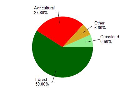
Arbutus Lake* is located in the Halls Creek watershed which is 115.13 mi². Land use in the watershed is primarily forest (59%), agricultural (27.80%) and a mix of grassland (6.60%) and other uses (6.60%). This watershed has 214.37 stream miles, 148.87 lake acres and 7,228.50 wetland acres.
Nonpoint Source Characteristics
This watershed is ranked High for runoff impacts on streams, Not Available for runoff impacts on lakes and Medium for runoff impacts on groundwater and therefore has an overall rank of Medium. This value can be used in ranking the watershed or individual waterbodies for grant funding under state and county programs.However, all waters are affected by diffuse pollutant sources regardless of initial water quality. Applications for specific runoff projects under state or county grant programs may be pursued. For more information, go to surface water program grants.