Clark
No
No
No
Fish and Aquatic Life
Overview
Bear Creek is a seven mile stream which flows through the City of Loyal to Rock Creek. It is classified in NR104 as a limited forage fish community from the headwaters to the section line between sections 5 and 8 (T26N, R1W). Downstream of this section line the stream is classified as a warmwater forage fish community. The stream drains primarily agricultural lands and has low flows and a low gradient. In 1991, a dam was built on Bear Creek in Loyal. Co-owners of the dam are the City of Loyal and American Legion Post 175. The purpose of dam was to provide recreation and fire protection. The earthen and concrete structure has a top discharge that creates a normal pool size ranging from 0.5 to 3.4 acres and receives drainage from 3.3 square miles of land (Bourget).
A 1982 study of Bear Creek downstream of the Loyal WWTP found that effluent was severely degrading stream water quality (Eslien). The Loyal wastewater treatment plant was upgraded in 1983 and the discharge relocated to the Black River.
From: Koperksi, Cindy. 1999. Black River Water Quality Management Plan (draft). Wisconsin Department of Natural Resources, Madison, WI.
Date 1999
Author Cynthia Koperski
Historical Description
Bear Creek T27N, RIW, S3, Surface Acres = 7.2, Miles = 5.4.
Bear Creek is a clear, hard water stream that flows northwest into Rock Creek. The stream flows through cleared land about one-half of i t s course and 90 percent of the watershed is cleared land. It has primarily a forage species fishery. There are no public lands adjoining the stream. Access is possible from five road crossings.
From: Klick, Thomas A. and C.W. Threinen, 1965. Surface Water Resources of Clark County: Lake and Stream Classification Project. Wisconsin Conservation Department, Madison, WI.
Date 1965
Author Aquatic Biologist
Condition
Wisconsin has over 84,000 miles of streams, 15,000 lakes and milllions of acres of wetlands. Assessing the condition of this vast amount of water is challenging. The state's water monitoring program uses a media-based, cross-program approach to analyze water condition. An updated monitoring strategy (2015-2020) is now available. Compliance with Clean Water Act fishable, swimmable standards are located in the Executive Summary of Water Condition in 2018. See also the 'monitoring and projects' tab.
Reports
Recommendations
Monitor Aquatic Biology
Conduct biological (mIBI or fIBI) monitoring on Bear Creek, WBIC: 1751000, AU:14271
Management Goals
Wisconsin's Water Quality Standards provide qualitative and quantitative goals for waters that are protective of Fishable, Swimmable conditions [Learn more]. Waters that do not meet water quality standards are considered impaired and restoration actions are planned and carried out until the water is once again fishable and swimmable
Management goals can include creation or implementation of a Total Maximum Daily Load analysis, a Nine Key Element Plan, or other restoration work, education and outreach and more. If specific recommendations exist for this water, they will be displayed below online.
Monitoring
Monitoring the condition of a river, stream, or lake includes gathering physical, chemical, biological, and habitat data. Comprehensive studies often gather all these parameters in great detail, while lighter assessment events will involve sampling physical, chemical and biological data such as macroinvertebrates. Aquatic macroinvertebrates and fish communities integrate watershed or catchment condition, providing great insight into overall ecosystem health. Chemical and habitat parameters tell researchers more about human induced problems including contaminated runoff, point source dischargers, or habitat issues that foster or limit the potential of aquatic communities to thrive in a given area. Wisconsin's Water Monitoring Strategy was recenty updated.
Grants and Management Projects
Monitoring Projects
| WBIC | Official Waterbody Name | Station ID | Station Name | Earliest Fieldwork Date | Latest Fieldwork Date | View Station | View Data |
|---|
| 1751000 | Bear Creek | 10038256 | Bear Creek upstream STH 98 | 8/23/2012 | 1/1/2015 | Map | Data |
| 1751000 | Bear Creek | 10032317 | Bear Creek at Hwy. K bridge | | | Map | Data |
| 3000572 | Unnamed | 10053795 | Loyal Pond | | | Map | Data |
|
Watershed Characteristics
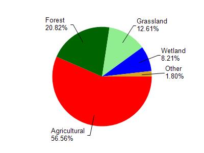
Bear Creek is located in the Cawley and Rock Creeks watershed which is 168.79 mi². Land use in the watershed is primarily agricultural (56.50%), forest (20.80%) and a mix of grassland (12.60%) and other uses (10.00%). This watershed has 342.79 stream miles, 108.66 lake acres and 6,081.99 wetland acres.
Nonpoint Source Characteristics
This watershed is ranked Not Ranked for runoff impacts on streams, Not Available for runoff impacts on lakes and High for runoff impacts on groundwater and therefore has an overall rank of High. This value can be used in ranking the watershed or individual waterbodies for grant funding under state and county programs.However, all waters are affected by diffuse pollutant sources regardless of initial water quality. Applications for specific runoff projects under state or county grant programs may be pursued. For more information, go to surface water program grants.