Oconto
Yes
No
No
Fish and Aquatic Life
Historical Description
The Oconto River arises at the confluence of the North Branch and South Branch Oconto
rivers near Suring, flowing south, then east, to Green Bay. It is a hard-water stream,
containing slightly alkaline water. Oconto Falls Pond and the Machickanee Flowage are
impoundments on the river. Information on both impoundments is contained in the
Lakes Report.
Fish inhabiting the river include northern pike, walleye, largemouth bass, smallmouth
bass, panfish, carp and trout. Brook, brown and rainbow trout are present in the upper
portions of the river where it is classified as a Class III trout stream. Seasonal runs of
Great Lakes trout and salmon occur at the mouth.
The Army Corps of Engineers maintains a federal navigation channel at the mouth of the
Oconto River. The harbor and navigation channel were last dredged in 1974. The Corps
found elevated levels of oil and grease in some sediment samples taken from the
navigation channel in the late-1980s.
The lower Oconto River was one of the most seriously degraded rivers in the state in the
mid- 1970s. In 1975, the river was the largest single source of ammonia nitrogen on the
Wisconsin side of Lake Michigan. The source of pollution was the Scott Paper Company
pulp and paper mill in Oconto Falls. The state of Wisconsin and the U.S. Environmental
Protection Agency initiated enforcement action against Scott in 1977.
Scott Paper Company ceased its pulping operations at Oconto Falls in 1978. In January,
1979, enforcement actions against Scott were settled by stipulation before trial with
Scott paying a $1 million settlement. DNR was allocated $600,000 to develop and
implement a restoration and management plan for the lower Oconto River including the
Machickanee Flowage. Results were to include improvements to fish and wildlife
habitats, aquatic environments, water quality and recreational opportunities.
Background studies conducted in 1979 and 1980 determined existing conditions and
assessed management alternatives. Extensive public involvement efforts were made and
public input into the planning process was solicited. The field investigations showed
water quality below Oconto Falls had improved dramatically since 1978. The fishery in
the river below the Machickanee Flowage had catchable numbers of smallmouth bass,
walleye, northern pike, panfish, trout and salmon. However, the fishery in the
Machickanee Flowage and the river above the flowage consisted of more than 90 percent
rough fish (carp, bullheads and suckers). The approximately two million cubic yards of
soft sediment in the flowage was the apparent limiting factor in establishing a viable
sport fishery as this sediment was an unsuitable substrate for fish spawning,
macroinvertebrates and rooted aquatic plants.
Date 1993
Author Surface Water Inventory Of Wisconsin
Historical Description
A plan for the restoration of the Oconto River was completed in October, 1980. The
plan recommended continued water quality and fisheries management, drawdown of the
Machickanee Flowage to allow the sediments to dry and compact, chemical treatment for
rough fish removal from the flowage, stocking of various sport fish species, development
of public access sites, and habitat improvements.
Plan implementation began in May, 198 1, with drawdown of the Machickanee Flowage to
the sill of the Stiles dam, almost down to the old river channel. As the sediment
dewatered and dried, considerable compaction occurred. The sediment volume was
reduced by 26 to 49 percent depending on site location and particle size. As sediment
dried, terrestrial vegetation quickly sprouted in the cracks. Most areas of the sediment
were covered by a thick growth of vegetation by the end of the summer.
In September, 1981 the Scott Flowage in Oconto Falls was drawn down for one day to
allow mechanical removal of rough fish between the Scott dam and the Wisconsin
Electric Power Company dam one half mile upstream. Two days after mechanical
removal chemical treatment was used to rid the system of remaining rough fish. More
than 47,000 pounds of fish were removed from the flowage, which was then slowly
refilled. Restocking of more desirable sport fish species began in the fall of 1981 and
continued through 1983.
A number of capital improvements to local facilities have enhanced the Oconto River
area. A grant of $50,000 from the Scott Paper Company settlement money was given to
the city of Oconto Falls to design and construct a new wastewater treatment plant. A
county-owned fishing access area, including boat ramp and dock, parking area.
restrooms, and accessible pier was constructed at a cost of $3 1,000. Two additional
county-owned and two city-owned access areas were also developed.
The Oconto Electric Cooperative (OEC) operates the Stiles dam, which creates the
Machickanee Flowage. as a "peaking" facility, generating at full capacity at "peak" demand
periods and cutting back generation during "off-peak" hours. This mode of operation
results in rapid, large fluctuations in flow from less then 200 cubic feet per second (cfs)
to 1,000 cfs in 20 to 30 minutes, and prolonged periods of reduced flow, sometimes less
than 125 cfs. After a large fishkill in July, 1983, that coincided with a period of low
flows, the DNR initiated a petition to the Federal Energy Regulatory Commission (FERC)
requesting an increase in minimum flows.
Date 1993
Author Surface Water Inventory Of Wisconsin
Historical Description
After numerous attempts at negotiating an increase in flow, the DNR and the US. Fish
and Wildlife Service conducted an In-stream Flow Incremental Methodology (IFIM) study
to determine the effects of the dam operation on the quantity and quality of aquatic
habitat in the lower river. The IFIM study results indicated the Stiles dam should be
operated with the following monthly minimum flows in order to protect habitat for
smallmouth bass. rainbow trout and invertebrates:
Month cfs
October 455
November 569
December 486
January 354
February 345
March 558
April 1,242
May 892
June 705
July 410
August 384
September 468
The study further recommended that these flows (or, if lower, the natural flow of the
river above the Stiles dam) be adopted as the minimum constant releases from the Stiles
dam.
In September, 1987, DNR filed an amended petition with FERC requesting monthly
minimum flows of 345 cfs in February to a minimum flow of 1,242 cfs in April, as
reflected in the study, with fluctuations of no more than 1.2 foot on the flowage.
Oconto Electric Cooperative, in opposition to the petition, submitted a statement on the
"Impact of Increased Minimum Flow Releases on Revenue Generated by the Oconto
Electric Cooperative Stiles Hydroplant." The U.S. Department of Interior filed a motion
to intervene which reiterated and supported the position expressed by DNR. Oconto
Electric Cooperative also filed a motion to intervene. Additionally, FERC received
comments from several citizens, the Department of Interior's Office of Environmental
Project Review and the National Rural Electric Cooperative Association. In January.
1990, at the request of FERC staff, Oconto Electric Cooperative filed an "Assessment of
Alternative Minimum Flow Regimes on Project Revenues."
Date 1993
Author Surface Water Inventory Of Wisconsin
Historical Description
The staff at FERC reviewed DNR's petition and materials supplied by Oconto Electric
Cooperative. FERC weighed the benefits to the fishery associated with the proposed flow
regime against those provided by DNR and the U.S. Fish & Wildlife Service, as well as
the costs to the project. FERC's final order amending Oconto Electric's license required
the following flows:
Month cfs
November 1 - February 28/29 200
March 1 - April 30 317
May 1 -June 30 572
July 1 - July 31 410
August 1 - September 30 370
October 1 - October 3 1 317
FERC further ordered that the level in the reservoir be maintained at 108.8 to 110 feet.
Studies and modeling of the assimilative capacity of the Oconto River between Oconto
Falls and Oconto were conducted in 1989 (Fenske, 1989). Major influences on dissolved
oxygen included re-aeration, photosynthesis, and river flow. The studies concluded that
wastewater discharges from Scott Paper Company and the village of Oconto Falls do not
significantly impact dissolved oxygen levels and that wasteload allocations are not
necessary to protect water quality in this segment of the river.
Aquatic plants (milfoil) are abundant from Stiles downstream. The Bureau of Fisheries
Management continues to stock portions of the Oconto River.
The exotic zebra mussel (Dreissena polymorpha) has been found in Green Bay waters.
Concern has arisen that the mussel may alter the ecology of Wisconsin's inland aquatic
systems. Zebra mussels also pose a threat to water intake systems, which become
clogged with the mussels, and have been known to impact recreational activities such as
boating and fishing. The DNR should monitor the spread of this invader.
Date 1993
Author Surface Water Inventory Of Wisconsin
Recommendations
Best Management Practices, Implement
Partnering with property owners, Machickanee Advancement Association is sponsoring a grant to implement water quality and habitat best practices from Wisconsin's Healthy Lakes Implementation Plan. Best practices, including fish sticks, 350 sq. ft. native plantings, diversions, rock infiltration, and/or rain gardens, will be designed and installed according to the Healthy Lakes fact sheets, technical guidance and grant application.
Monitor Fish Tissue
440200 name Oconto River TMDL ID 173 Start Mile 0 End Mile 9.94
Monitor Fish Tissue
440200 name Oconto River TMDL ID 173 Start Mile 10.41 End Mile 14.63
Management Goals
Wisconsin's Water Quality Standards provide qualitative and quantitative goals for waters that are protective of Fishable, Swimmable conditions [Learn more]. Waters that do not meet water quality standards are considered impaired and restoration actions are planned and carried out until the water is once again fishable and swimmable
Management goals can include creation or implementation of a Total Maximum Daily Load analysis, a Nine Key Element Plan, or other restoration work, education and outreach and more. If specific recommendations exist for this water, they will be displayed below online.
Monitoring
Monitoring the condition of a river, stream, or lake includes gathering physical, chemical, biological, and habitat data. Comprehensive studies often gather all these parameters in great detail, while lighter assessment events will involve sampling physical, chemical and biological data such as macroinvertebrates. Aquatic macroinvertebrates and fish communities integrate watershed or catchment condition, providing great insight into overall ecosystem health. Chemical and habitat parameters tell researchers more about human induced problems including contaminated runoff, point source dischargers, or habitat issues that foster or limit the potential of aquatic communities to thrive in a given area. Wisconsin's Water Monitoring Strategy was recenty updated.
Grants and Management Projects
Monitoring Projects
| WBIC | Official Waterbody Name | Station ID | Station Name | Earliest Fieldwork Date | Latest Fieldwork Date | View Station | View Data |
|---|
| 440200 | Oconto River | 10053719 | Test - ZD | | | Map | Data |
| 440200 | Oconto River | 433019 | Oconto River - Sth 32 Bridge-Suring | 1/14/1993 | 1/1/2015 | Map | Data |
| 440200 | Oconto River | 10044761 | Oconto River-Hwy 32 | 1/1/2015 | 5/20/2015 | Map | Data |
| 440200 | Oconto River | 10004139 | Oconto River - 05 Mouth | 7/16/2018 | 8/13/2019 | Map | Data |
| 440200 | Oconto River | 10004140 | Oconto River - 16 Machikanee Flow | | | Map | Data |
| 440200 | Oconto River | 10044760 | Oconto River-Cty H | 1/1/2015 | 6/2/2016 | Map | Data |
| 440200 | Oconto River | 10052600 | Octonto River, Northeast of Town of How | 7/8/2019 | 7/8/2019 | Map | Data |
| 440200 | Oconto River | 10019429 | Oconto River -- Access Nr Sth 32 Suring | | | Map | Data |
| 440200 | Oconto River | 10004134 | Oconto River - 10 Oconto | 9/27/2018 | 9/27/2018 | Map | Data |
| 440200 | Oconto River | 10004142 | Oconto River - 15 Bel Stiles Dam | 7/27/1999 | 9/2/2001 | Map | Data |
| 440200 | Oconto River | 10010135 | Oconto River at Hwy 32 In Suring | | | Map | Data |
| 440200 | Oconto River | 433021 | Oconto River - Off River Rd Bel Suring | | | Map | Data |
| 440200 | Oconto River | 10004143 | Oconto River - 25 Hy 32 | | | Map | Data |
| 440200 | Oconto River | 433020 | Oconto River - Suring Stp | 7/6/1977 | 6/15/1984 | Map | Data |
| 440200 | Oconto River | 10030894 | Oconto River -- Patzer Park Boat Ramp | | | Map | Data |
| 440200 | Oconto River | 433095 | Oconto River at Cth H Nr Hintz | 5/23/1980 | 5/12/2017 | Map | Data |
|
Watershed Characteristics
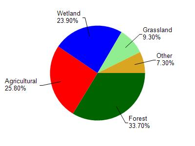
Oconto River is located in the Lower Oconto River watershed which is 196.48 mi². Land use in the watershed is primarily forest (33.70%), agricultural (25.80%) and a mix of wetland (23.90%) and other uses (16.60%). This watershed has 314.34 stream miles, 3,972.16 lake acres and 24,684.40 wetland acres.
Nonpoint Source Characteristics
This watershed is ranked Low for runoff impacts on streams, Not Ranked for runoff impacts on lakes and High for runoff impacts on groundwater and therefore has an overall rank of High. This value can be used in ranking the watershed or individual waterbodies for grant funding under state and county programs.However, all waters are affected by diffuse pollutant sources regardless of initial water quality. Applications for specific runoff projects under state or county grant programs may be pursued. For more information, go to surface water program grants.