Douglas
No
No
No
Fish and Aquatic Life
Overview
The Red River is an approximately 7.4 mile stream that originates at springs in Jay Cooke State Park in Minnesota, flowing northeasterly in Wisconsin. Red clay soils and steep topography, with sharply rolling hills and some bank slippage and erosion, characterize areas in this watershed. The deeply eroded clay river valley exhibits relief approaching 300 feet in places. Due to common flow extremes, the stream’s unstable sand, gravel, and clay bottom is susceptible to disturbance and bottom scouring. Cedar, spruce and upland hardwoods dominate the watershed.
The stream flows into the St. Louis River west of Oliver through a large tract of land previously purchased by WDNR for the purpose of protecting the fishery of the St. Louis River. More than 5,000 acres of the watershed were obtained from a single owner to become part of the St. Louis River Streambank Protection Project. The Lake Superior Binational Program identified this watershed as important to the integrity of the Lake Superior ecosystem for coastal wetlands and contribution to ecosystem integrity.
The Red River’s attainable use designation and fisheries classification is as a Class I trout stream. Current use designation is listed as a Class III trout stream, showing poor use support. In addition to brook trout, other species known to inhabit the river have included northern pike, rock bass, white sucker, burbot, creek chubs and sculpin. However, baseline fishery surveys performed in 2006 and 2008 (including a survey on unnamed tributary: WBIC-5000984) did not result in sampling trout, further suggesting poor support of the current use designation. Historical surveys indicate brook trout were collected in 1972, but were not in 1964. Although 6.3 miles of the Red River in Wisconsin is listed as an Exceptional Resource Water (ERW), survey work appears to indicate water quality could be potentially declining based on lower coldwater fish IBI scores and habitat ratings. As part of coastal wetlands evaluation, Epstein (1997) found moderate richness of invertebrate taxa present, but noted significant turbidity, iron bacteria, marl, sludge, low flows and bank erosion.
Date 2011
Author Nancy Larson
Historical Description
Red clay soils and steep topography, with sharply rolling hills and some bank slippage and erosion, characterize this watershed. The stream, listed as a Class I trout stream supporting a reproducing population of brook trout, flows into the St. Louis River west of Oliver through a large tract of land recently purchased by WDNR for the purpose of protecting the valuable fishery of the St. Louis River. More than 5,000 acres of the watershed were obtained from a single owner to become part of the St. Louis River Streambank Protection Project. The project includes the river, five miles of shoreline and 14 islands on and in the St. Louis River. This part of the St. Louis River estuary includes some of its last remaining shoreline wetlands, which provide prime breeding habitat for wildlife and fish, including some 300 species of birds, threatened and endangered species, game species and an estimated 50,000-90,000 spawning walleye. Lake sturgeon have been reintroduced in the area recently. The Lake Superior Binational Program identified this watershed as important to the integrity of the Lake Superior ecosystem for coastal wetlands, contribution to ecosystem integrity - landscape scale, diversity, vital functions for planning objectives, threatened and endangered species habitat, and fish and wildlife spawning and nursery grounds. (See discussion of critical habitat definitions under Basinwide Issues. Also see discussion, above, of St. Louis River and Red River Breaks under Priority Wetlands.)
The stream originates at springs in Jay Cooke State Park in Minnesota, flowing northeasterly in Wisconsin. The deeply eroded clay river valley exhibits relief approaching 300 feet in places. Flow extremes are common and sometimes cause bottom scouring. The stream's unstable sand, gravel and clay bottom is susceptible to disturbance. Species known to inhabit this river include northern pike, rock bass, white sucker, burbot, creek chubs and sculpin. Cedar, spruce and upland hardwoods dominate the watershed. There are no highway accesses to this area.
During survey work conducted as part of the coastal wetlands evaluation, one rare macroinvertebrate was found in the stream, which was determined to have moderate richness of taxa present. At the survey sites, staff recorded significant turbidity, iron bacteria, marl, sludge, low flows and bank erosion. Present as well were aquatic plant growth, silt and filamentous algae. (Epstein 1997.)
From: Turville-Heitz, Meg. 1999. Lake Superior Basin Water Quality Management Plan. Wisconsin Department of Natural Resources, Madison, WI.
Date 1999
Author Aquatic Biologist
Recommendations
Monitor Aquatic Biology
Conduct biological (mIBI or fIBI) monitoring on Red River, WBIC: 2845800, AU:17470
Monitor Targeted Area
Future 303(d) assessment and monitoring of the Red River and several tributaries is recommended to determine current status of stream/watershed condition and to confirm brook trout presence/absence.
Management Goals
Wisconsin's Water Quality Standards provide qualitative and quantitative goals for waters that are protective of Fishable, Swimmable conditions [Learn more]. Waters that do not meet water quality standards are considered impaired and restoration actions are planned and carried out until the water is once again fishable and swimmable
Management goals can include creation or implementation of a Total Maximum Daily Load analysis, a Nine Key Element Plan, or other restoration work, education and outreach and more. If specific recommendations exist for this water, they will be displayed below online.
Monitoring
Monitoring the condition of a river, stream, or lake includes gathering physical, chemical, biological, and habitat data. Comprehensive studies often gather all these parameters in great detail, while lighter assessment events will involve sampling physical, chemical and biological data such as macroinvertebrates. Aquatic macroinvertebrates and fish communities integrate watershed or catchment condition, providing great insight into overall ecosystem health. Chemical and habitat parameters tell researchers more about human induced problems including contaminated runoff, point source dischargers, or habitat issues that foster or limit the potential of aquatic communities to thrive in a given area. Wisconsin's Water Monitoring Strategy was recenty updated.
Grants and Management Projects
Monitoring Projects
| WBIC | Official Waterbody Name | Station ID | Station Name | Earliest Fieldwork Date | Latest Fieldwork Date | View Station | View Data |
|---|
| 2845800 | Red River | 10015468 | Red River- Walk In North Of Intersection Of Hwy W And Hwy C-Station #2 | 6/13/2012 | 1/1/2015 | Map | Data |
|
Watershed Characteristics
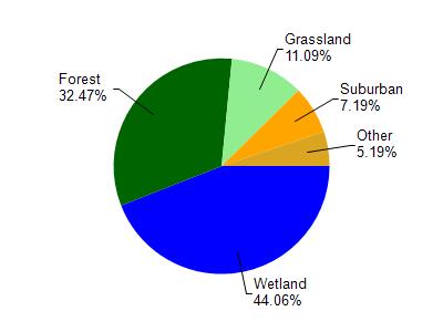
Red River is located in the St. Louis and Lower Nemadji River watershed which is 159.67 mi². Land use in the watershed is primarily wetland (44.10%), forest (32.50%) and a mix of grassland (11.10%) and other uses (12.40%). This watershed has 432.66 stream miles, 8,490.75 lake acres and 26,945.85 wetland acres.
Nonpoint Source Characteristics
This watershed is ranked Not Ranked for runoff impacts on streams, Not Available for runoff impacts on lakes and Low for runoff impacts on groundwater and therefore has an overall rank of Low. This value can be used in ranking the watershed or individual waterbodies for grant funding under state and county programs.However, all waters are affected by diffuse pollutant sources regardless of initial water quality. Applications for specific runoff projects under state or county grant programs may be pursued. For more information, go to surface water program grants.