La Crosse, Monroe
Yes
No
No
Fish and Aquatic Life
Overview
Coon Creek, located in northwestern Vernon County, flows in a southwesterly direction for approximately 22 miles before reaching the Mississippi River near Stoddard. It has a slight gradient of 7.1 feet per mile and drains steep forested hillsides and agricultural lands. Coon Creek is a Class III trout stream from STH 35 upstream to CTH K at Chaseburg and Class II from CTH K upstream to the confluence of Bohemian Valley and Timber Coulee Creeks northeast of Coon Valley.
Bohemian Valley Creek, which is the upper nine miles of Coon Creek, begins in Monroe County and flows for 9 miles in a southwesterly direction, cutting through the southeastern corner of La Crosse County into Vernon County. It has a moderate gradient of 45 feet per mile and drains steep sloped agricultural land and forested hillsides as well as lowland pasture. Bohemian Valley Creek is a Class I trout stream for its entire length.
Date 2011
Author Cynthia Koperski
Historical Description
This tributary of the Mississippi River heads in Monroe County, flows through the southeast portion of La Crosse County, and in a general westerly direction through the northwestern portion of Vernon County to the Mississippi. That portion of the creek in Monroe and La Crosse Counties, and from the junction of Timber Coulee Creek upstream in Vernon County, is locally known as Bohemian Valley Creek. The portion of stream above the County Trunk Highway "K" road crossing is Class III brown trout water. White suckers, longnose dace, Johnny darters, blacknose dace and creek chubs are also present. The winter aerial groundwater survey found open water from about midway between Chaseburg and Coon Valley upstream. While the dominant bottom type is sand, there is considerable silt and small amounts of gravel, rubble, and boulder. Access is possible from many road crossings, the Coon Valley Park, and from the Mississippi River. The lower portion of the stream flows through the Upper Mississippi National Wildlife Refuge. There are about }38 acres of adjoining wetland. Muskrat are significant and beaver are present. Teal, mallards, and wood ducks nest along the stream, and considerable numbers of dabbler and diving ducks use the water during periods of migration.
Coon Creek. T14N, R7W, Section 33. Surface Acres = 76.7, Miles = 22.0, Gradient = 7.1 feet per mile.
From: Klick, Thomas A. and Threinen, C.W., 1973. Lake and Stream Classification Project. Surface Water Resources of Vernon County, Wisconsin Department of Natural Resources, Madison, WI.
Date 1973
Author Aquatic Biologist
General Condition
Coon Creek (WBIC 1643500) from CTH K in Chaseburg to the Vernon/La Crosse County line was assessed during the 2018 listing cycle; new biological (fish Index of Biotic Integrity (IBI) scores) sample data were clearly below the 2018 WisCALM listing thresholds for the Fish and Aquatic Life use. This water was meeting this designated use and was not considered impaired.
Date 2017
Author Ashley Beranek
General Condition
Access to Coon Creek is possible from numerous road crossings, the Coon Valley Park at STH 14/61, WDNR easements, WDNR owned land, and from the Mississippi River. The lower portion of the stream flows through the Upper Mississippi National Wildlife Refuge. The Village of Chaseburg has a walking trail and wheelchair accessible fishing to Coon Creek. The Village of Coon Valley Park provides a looped walking path along both sides of Coon Creek with two bridges and wheelchair accessible trout fishing. The deep, swift current, in-stream habitat structures, and easy access create an enjoyable fishing experience for many.
Date 2011
Author Cynthia Koperski
Impaired Waters
The Coon Creek, from its mouth to CTH K in Chaseburg (milse 0 to 13) was put on the impaired waters list for phosphorus in the 2012 cycle. This stream segment was assessed during the 2018 listing cycle; total phosphorus sample data clearly exceeded the 2018 WisCALM listing thresholds for the Fish and Aquatic Life use. Available biological data did not indicate impairment (i.e. no macroinvertebrate or fish Index of Biotic Integrity (IBI) scored in the "poor" condition category). This water was not meeting this designated use and was considered impaired. No listing change was needed to this already impaired water.
Date 2017
Author Ashley Beranek
Condition
Wisconsin has over 84,000 miles of streams, 15,000 lakes and milllions of acres of wetlands. Assessing the condition of this vast amount of water is challenging. The state's water monitoring program uses a media-based, cross-program approach to analyze water condition. An updated monitoring strategy (2015-2020) is now available. Compliance with Clean Water Act fishable, swimmable standards are located in the Executive Summary of Water Condition in 2018. See also the 'monitoring and projects' tab.
Reports
Recommendations
Monitor or Assess Watershed Condition
IR Assessments and WT Planning Conducted in 2010-11
Water Quality Planning
Watershed Planning was conducted in 2011 and the plan published online of that year.
Habitat Restoration - Instream
The WDNR should continue in-stream habitat restoration in all streams where necessary in Coon Creek Fishery Area streams.
Natural Areas Protection
The WDNR should extend the Coon Creek Fishery Area to include Coon Creek downstream of Chaseburg to the Mississippi River.
Management Goals
Wisconsin's Water Quality Standards provide qualitative and quantitative goals for waters that are protective of Fishable, Swimmable conditions [Learn more]. Waters that do not meet water quality standards are considered impaired and restoration actions are planned and carried out until the water is once again fishable and swimmable
Management goals can include creation or implementation of a Total Maximum Daily Load analysis, a Nine Key Element Plan, or other restoration work, education and outreach and more. If specific recommendations exist for this water, they will be displayed below online.
Monitoring
Monitoring the condition of a river, stream, or lake includes gathering physical, chemical, biological, and habitat data. Comprehensive studies often gather all these parameters in great detail, while lighter assessment events will involve sampling physical, chemical and biological data such as macroinvertebrates. Aquatic macroinvertebrates and fish communities integrate watershed or catchment condition, providing great insight into overall ecosystem health. Chemical and habitat parameters tell researchers more about human induced problems including contaminated runoff, point source dischargers, or habitat issues that foster or limit the potential of aquatic communities to thrive in a given area. Wisconsin's Water Monitoring Strategy was recenty updated.
Grants and Management Projects
Monitoring Projects
| WBIC | Official Waterbody Name | Station ID | Station Name | Earliest Fieldwork Date | Latest Fieldwork Date | View Station | View Data |
|---|
| 1643500 | Coon Creek | 10013957 | Coon Creek(Bohemian Valley)Station 2-1977-Ne 1/4 Sw 1/4 S17-Starts 1300' Downstream Of Cth Y Bridge | | | Map | Data |
| 1643500 | Coon Creek | 10013955 | Coon Creek(Bohemian Valley)Station 1-1977-Nw 1/4 Ne 1/4 S19-Starts At Water Control Structure. | | | Map | Data |
| 1643500 | Coon Creek | 10013922 | Coon Creek(Bohemian Valley) Station 9-Nw 1/4 Ne 1/4 S19-900' Downstream Of Pl 566 Dam Outlet Pipe | | | Map | Data |
|
Monitoring Studies
The most recent habitat survey, conducted in 2009, documented a stream bottom consisting mainly of sand and clay with lesser amounts of silt, gravel, detritus and rubble. Riparian land use was comprised of mostly woodland with some home development and meadow areas. Aquatic insects were also collected in 2009 and the Macroinvertebrate Index of Biological Integrity (MIBI) score was determined to be poor (1.69). Seven fi sh collections have occurred in this stream since 2007 with game fi sh such as brown trout, brook trout, tiger trout (brook and brown trout hybrid), northern pike, green sunfi sh, largemouth bass, and pumpkinseed being found. The coldwater Fish Index of Biological Integrity (FIBI) was calculated for the fi sh collections, resulting in four fair and three good scores, indicating water quality adequate to support a cold water fi shery. Chipmunk Coulee Creek would benefi t from the acquisition of streambank easements and in-stream habitat restoration. Access is possible from four road crossings and the Upper Mississippi River National Wildlife Refuge.
Date 2011
Author Christopher Pracheil
Watershed Characteristics
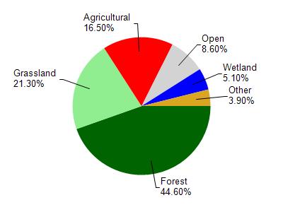
Coon Creek is located in the Coon Creek watershed which is 238.20 mi². Land use in the watershed is primarily forest (44.60%), grassland (21.30%) and a mix of agricultural (16.50%) and other uses (17.60%). This watershed has 574.90 stream miles, 4,342.05 lake acres and 6,052.31 wetland acres.
Nonpoint Source Characteristics
This watershed is ranked High for runoff impacts on streams, Not Ranked for runoff impacts on lakes and Medium for runoff impacts on groundwater and therefore has an overall rank of Medium. This value can be used in ranking the watershed or individual waterbodies for grant funding under state and county programs.This water is ranked Medium Stream for individual Rivers based on runoff problems and the likelihood of success from project implementation.