Barron
No
No
Yes
Fish and Aquatic Life
Overview
Mud (Ojaski) Lake, in the Lake Chetek Watershed, is a 331.92 acre lake that falls in Barron County. This lake is managed for fishing and swimming and is currently considered impaired.
Date 2011
Author Aquatic Biologist
Historical Description
A soft water drainage lake in the Chetek Lake Chain. Its level is maintained by the water control structure on Lake Chetek. The lake's fish population consists of northern pike, walleyes,largemouth bass, bluegills, black crappies, pumpkinseeds and bullheads. Other species present include perch, smallmouth bass, rock bass and white suckers. Pokegama Creek, which flows into Mud Lake from the north provides a spawning area for northerns and walleyes. Excessive algal growth is a problem to this lake's use and management. Located in the farming area, the lake is surrounded by upland hardwoods, white pine and cultivated farmland. The lower half of the lake has a considerable amount of private development on it, with three resorts, three boat liveries and 50 cottages and homes. About three acre of marsh wetlands on the northeast shore provide habitat for muskrats, nesting mallards, teal and wood ducks. The lake is accessible by two blacktopped boat landings. Other
public frontage on the lake consists of four undeveloped roads in plats. Source: 1964, Surface Water Resources of Barron County Mud Lake - Town of Chetek T33N, RIOW, Sections 6, 7 Surface Acres = 567.1, S.D.F. = 2.45, Maximum Depth = 15 feet
Date 1964
Author Surface Water Inventory Of Wisconsin
Condition
Wisconsin has over 84,000 miles of streams, 15,000 lakes and milllions of acres of wetlands. Assessing the condition of this vast amount of water is challenging. The state's water monitoring program uses a media-based, cross-program approach to analyze water condition. An updated monitoring strategy (2015-2020) is now available. Compliance with Clean Water Act fishable, swimmable standards are located in the Executive Summary of Water Condition in 2018. See also the 'monitoring and projects' tab.
Reports
Management Goals
Wisconsin's Water Quality Standards provide qualitative and quantitative goals for waters that are protective of Fishable, Swimmable conditions [Learn more]. Waters that do not meet water quality standards are considered impaired and restoration actions are planned and carried out until the water is once again fishable and swimmable
Management goals can include creation or implementation of a Total Maximum Daily Load analysis, a Nine Key Element Plan, or other restoration work, education and outreach and more. If specific recommendations exist for this water, they will be displayed below online.
Monitoring
Monitoring the condition of a river, stream, or lake includes gathering physical, chemical, biological, and habitat data. Comprehensive studies often gather all these parameters in great detail, while lighter assessment events will involve sampling physical, chemical and biological data such as macroinvertebrates. Aquatic macroinvertebrates and fish communities integrate watershed or catchment condition, providing great insight into overall ecosystem health. Chemical and habitat parameters tell researchers more about human induced problems including contaminated runoff, point source dischargers, or habitat issues that foster or limit the potential of aquatic communities to thrive in a given area. Wisconsin's Water Monitoring Strategy was recenty updated.
Grants and Management Projects
Monitoring Projects
| WBIC | Official Waterbody Name | Station ID | Station Name | Earliest Fieldwork Date | Latest Fieldwork Date | View Station | View Data |
|---|
| 2094600 | Mud Lake | 10018519 | Mud Lake -- Access at End Of 24 3/4 St | 8/3/2011 | 8/3/2011 | Map | Data |
| 2094600 | Mud Lake | 10018520 | Mud Lake -- Access at S Side Of Lake Off 10 1/8 | 8/8/2007 | 10/11/2024 | Map | Data |
| 2094600 | Mud Lake | 033150 | Mud Lake - Deep Hole - Nr Center Of S Basin | 3/10/1987 | 9/25/2025 | Map | Data |
| 2094600 | Mud Lake | 10030253 | Mud Lake at 10th Avenue Landing | | | Map | Data |
| 2094600 | Mud Lake | 10000765 | Mud Lake | 9/5/2000 | 8/19/2017 | Map | Data |
|
Watershed Characteristics
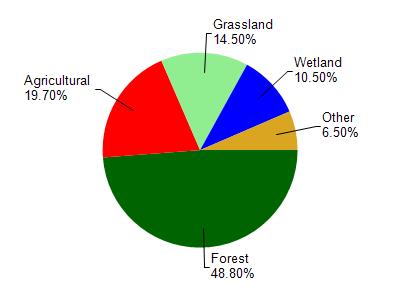
Mud Lake is located in the Lake Chetek watershed which is 212.00 mi². Land use in the watershed is primarily forest (48.80%), agricultural (19.70%) and a mix of grassland (14.50%) and other uses (17.00%). This watershed has 270.25 stream miles, 2,008.86 lake acres and 10,678.22 wetland acres.
Nonpoint Source Characteristics
This watershed is ranked Medium for runoff impacts on streams, High for runoff impacts on lakes and High for runoff impacts on groundwater and therefore has an overall rank of High. This value can be used in ranking the watershed or individual waterbodies for grant funding under state and county programs.However, all waters are affected by diffuse pollutant sources regardless of initial water quality. Applications for specific runoff projects under state or county grant programs may be pursued. For more information, go to surface water program grants.