Chippewa, Clark, Eau Claire
No
No
Yes
Fish and Aquatic Life
Overview
The Wolf River is 24 mile long warm water tributary to the North Fork of the Eau Claire River. The headwater reaches upstream from Chapman Lake are intermittent and fully support a warm water forage fishery. The stream is classified as a warm water sport fishery from the Chapman Lake dam downstream to the confluence with the North Fork Eau Claire River.
The Wolf River from the Chapman Lake dam downstream to Worden Road is not supporting its designated use due to dissolved oxygen standards violations. Therefore, this section of river is identified as impaired on the Federal 303 d list.
Date 2010
Author Paul Laliberte
Overview
Very little recent fishery and water quality data exists for the Wolf River. Macroinvertebrate sampling at the mouth in 1980 indicated good diversity. A sample site at Stanley, upstream of Chapman Pond, indicated less diversity, possibly due to the decreased water velocity. Monitoring of the Wolf River near Stanley documented dissolved oxygen problems under summer
conditions. Stream aeration has been limited during years when beaver significantly impound the river. This, in conjunction with low flow, contributes to the oxygen problem. Additionally, the Stanley discharge in this reach may be contributing to the problem. Data since the plant was renovated has not been evaluated.
Date 1996
Author Karen Voss
Historical Description
Wolf River T28N, R4W, S30, Surface Acres = 8.7, Miles = 6 .O, Gradient = 8.6 feet per mile.
A clear, medium hard water stream that flows southwest into the north fork
of the Eau Claire River in Eau Claire County. The stream meanders through
portions of Clark, Taylor, Chippewa, and Eau Claire Counties. It enters
Clark County first from Taylor County and then again from Chippewa County.
Its fishery consists primarily of panfish and forage species, but there may be bass and carp present as these two species have been reported in Chippewa County. About 67 percent of the land adjacent to the stream has been cleared as has 94 percent of the land included in the watershed area. There is no public land adjoining the stream. Access is possible from six road crossings.
From: Klick, Thomas A. and C.W. Threinen, 1965. Surface Water Resources of Clark County:
Lake and Stream Classification Project. Wisconsin Conservation Department, Madison, WI.
Date 1965
Author Surface Water Inventory Of Wisconsin
General Condition
Continuous monitoring indicates dissolved oxygen concentrations fluctuate substantially as a result of photosynthesis and respiration of filamentous algae. Oxygen levels can fall below the water quality standard during respiration of algae especially at times of hot temperatures and low flow periods. The growth of filamentous algae is a result of excessive nutrients, sluggish streamflow and the open canopy in this reach of stream. Downstream from Worden Road the stream corridor is mostly shaded and filamentous algae growth is minimal or absent. As a result, oxygen levels remain above the water quality standard.
Continuous dissolved oxygen monitoring completed upstream of Chapman Lake found concentrations below the water quality standard. The headwaters of the Wolf River are intermittent and flow through large wetland complexes. Low oxygen levels documented in the headwaters are a result of these natural environmental conditions. This section of river is not listed on the 303d list because these contributing factors are natural and uncontrollable.
Date 2010
Author Paul Laliberte
Impaired Waters
The 2018 assessments of the Wolf River (WBIC 2146000; Chapman Lake Dam to headwaters) showed impairment by phosphorus; new total phosphorus sample data exceeded the 2018 WisCALM listing criteria for the Fish and Aquatic Life use. However, available biological data did not indicate impairment (i.e. no macroinvertebrate Index of Biotic Integrity (IBI) scored in the "poor" condition category). Based on the most updated information, this water was proposed for the impaired waters list.
Date 2017
Author Ashley Beranek
Impaired Waters
The 2018 assessments of the Wolf River (WBIC 2146000; Mouth to Worden Road) showed impairment by phosphorus; new total phosphorus sample data overwhelmingly exceeded the 2018 WisCALM listing criteria for the Fish and Aquatic Life use. However, available biological data did not indicate impairment (i.e. no macroinvertebrate or fish Index of Biotic Integrity (IBI) scored in the "poor" condition category). Based on the most updated information, this water was proposed for the impaired waters list.
Date 2017
Author Ashley Beranek
Impaired Waters
The 2018 assessments of the Wolf River (WBIC 2146000; Worden Road upstream to Chapman Lake Dam) showed impairment by phosphorus; new total phosphorus sample data overwhelmingly exceeded the 2018 WisCALM listing criteria for the Fish and Aquatic Life use. However, available biological data did not indicate impairment (i.e. no macroinvertebrate or fish Index of Biotic Integrity (IBI) scored in the "poor" condition category). Based on the most updated information, no change in the existing impaired waters listing was needed.
Date 2017
Author Ashley Beranek
Condition
Wisconsin has over 84,000 miles of streams, 15,000 lakes and milllions of acres of wetlands. Assessing the condition of this vast amount of water is challenging. The state's water monitoring program uses a media-based, cross-program approach to analyze water condition. An updated monitoring strategy (2015-2020) is now available. Compliance with Clean Water Act fishable, swimmable standards are located in the Executive Summary of Water Condition in 2018. See also the 'monitoring and projects' tab.
Reports
Recommendations
Citizen-Based Stream Monitoring
Collect chemical, physical, and/or biological water quality data to assess the current overall stream health. The data can inform management decisions and may be used to identify impaired waters for biennial lists.
Restore Wetlands
Restore Wetlands
Restore Wetlands
Where opportunities arise, wetland restoration should be promoted.
TMDL Development
A TMDL needs to be completed for the 303d listed impaired reach of the Wolf River.
Monitor or Propose 303(d) Listing
WDNR should conduct additional continuous oxygen monitoring during
summer low flow conditions on the Wolf River and evaluate and report data
collected since the Stanley treatment plant was renovated (Type B).
Management Goals
Wisconsin's Water Quality Standards provide qualitative and quantitative goals for waters that are protective of Fishable, Swimmable conditions [Learn more]. Waters that do not meet water quality standards are considered impaired and restoration actions are planned and carried out until the water is once again fishable and swimmable
Management goals can include creation or implementation of a Total Maximum Daily Load analysis, a Nine Key Element Plan, or other restoration work, education and outreach and more. If specific recommendations exist for this water, they will be displayed below online.
Monitoring
Monitoring the condition of a river, stream, or lake includes gathering physical, chemical, biological, and habitat data. Comprehensive studies often gather all these parameters in great detail, while lighter assessment events will involve sampling physical, chemical and biological data such as macroinvertebrates. Aquatic macroinvertebrates and fish communities integrate watershed or catchment condition, providing great insight into overall ecosystem health. Chemical and habitat parameters tell researchers more about human induced problems including contaminated runoff, point source dischargers, or habitat issues that foster or limit the potential of aquatic communities to thrive in a given area. Wisconsin's Water Monitoring Strategy was recenty updated.
Grants and Management Projects
Monitoring Projects
| WBIC | Official Waterbody Name | Station ID | Station Name | Earliest Fieldwork Date | Latest Fieldwork Date | View Station | View Data |
|---|
| 2146000 | Wolf River | 10032356 | Wolf River at Hwy H near Stanley | | | Map | Data |
| 2146000 | Wolf River | 10043514 | Wolf River at Worden Road | 1/1/2015 | 10/13/2015 | Map | Data |
| 2146000 | Wolf River | 183065 | Wolf River - Nw1/4 Of Ne1/4 Of Sec.14 | 5/6/1980 | 7/3/2023 | Map | Data |
| 2146000 | Wolf River | 10010252 | Wolf River - Wolf River 3 River Rd. | 6/14/2006 | 8/6/2025 | Map | Data |
|
Watershed Characteristics
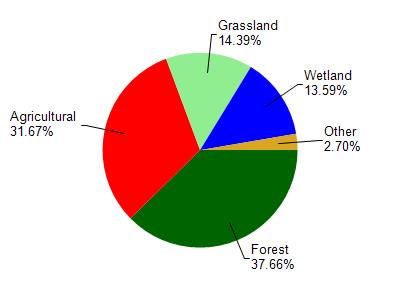
Wolf River is located in the North Fork Eau Claire River watershed which is 205.88 mi². Land use in the watershed is primarily forest (37.70%), agricultural (31.70%) and a mix of grassland (14.40%) and other uses (16.30%). This watershed has 411.76 stream miles, 302.30 lake acres and 18,394.61 wetland acres.
Nonpoint Source Characteristics
This watershed is ranked Low for runoff impacts on streams, Not Ranked for runoff impacts on lakes and High for runoff impacts on groundwater and therefore has an overall rank of High. This value can be used in ranking the watershed or individual waterbodies for grant funding under state and county programs.However, all waters are affected by diffuse pollutant sources regardless of initial water quality. Applications for specific runoff projects under state or county grant programs may be pursued. For more information, go to surface water program grants.