Washburn
No
No
No
Fish and Aquatic Life
Overview
Big Sand Lake, in the Lower Namekagon River Watershed, is a 210.29 acre lake that falls in Washburn County. This lake is managed for fishing and swimming and is currently not considered impaired.
Date 2011
Author Aquatic Biologist
Historical Description
Source: 1978, Surface Water Resources of Washburn County Sand Lake, T42N, R13W, Section 5, 8, Surface Acres-198.0, Maximum Depth-9 feet, M.P.A.-18 ppm, Secchi Disk-6 feet A soft water, seepage lake in the northwest corner of the county. It is landlocked and subject tO Occasional natural fluctuations in water levels. As a result of low water levels in some years, partial winter fish kills have occurred; the known years of which have been 1945 and 1965. The Present fishery is composed mainly of perch, bluegills, largemouth bass, and golden shiners. Species present in much lower abundance are northern pike, pumpkinseeds, and common shiners. Walleyes were introduced into the lake in 1974 and the success of this stocking is not yet known. Sand Lake is Pear shaped and during low water levels the south end becomes isolated from the main basin. Its depth at those times is about five feet. The maximum depth of the lake varies from about 7-12 feet. The lower basin separates between levels of about 10-11 feet. Nearly the entire shoreline of the lake is sand. Jack pine and scrub oak covers the lakeshore uplands, except off the small northwest bay where there is a leatherleaf bog and marsh of 44 acres in size. A 15-acre marsh is located off the east shore but is at this time separated from the main basin by a sand bar. Aquatic vegetation is sparse. Although the maximum depth of the lake at present is only nine feet, the average depth is over six feet. Furbearer use here is small, but some mallards and teal nest here. Private lakeshore development includes a resort and six cottages. The only public frontage is the Town of Minong access site on the southeast shore which has only limited space for parking.
Date 1978
Author Surface Water Inventory Of Wisconsin
Condition
Wisconsin has over 84,000 miles of streams, 15,000 lakes and milllions of acres of wetlands. Assessing the condition of this vast amount of water is challenging. The state's water monitoring program uses a media-based, cross-program approach to analyze water condition. An updated monitoring strategy (2015-2020) is now available. Compliance with Clean Water Act fishable, swimmable standards are located in the Executive Summary of Water Condition in 2018. See also the 'monitoring and projects' tab.
Reports
Management Goals
Wisconsin's Water Quality Standards provide qualitative and quantitative goals for waters that are protective of Fishable, Swimmable conditions [Learn more]. Waters that do not meet water quality standards are considered impaired and restoration actions are planned and carried out until the water is once again fishable and swimmable
Management goals can include creation or implementation of a Total Maximum Daily Load analysis, a Nine Key Element Plan, or other restoration work, education and outreach and more. If specific recommendations exist for this water, they will be displayed below online.
Monitoring
Monitoring the condition of a river, stream, or lake includes gathering physical, chemical, biological, and habitat data. Comprehensive studies often gather all these parameters in great detail, while lighter assessment events will involve sampling physical, chemical and biological data such as macroinvertebrates. Aquatic macroinvertebrates and fish communities integrate watershed or catchment condition, providing great insight into overall ecosystem health. Chemical and habitat parameters tell researchers more about human induced problems including contaminated runoff, point source dischargers, or habitat issues that foster or limit the potential of aquatic communities to thrive in a given area. Wisconsin's Water Monitoring Strategy was recenty updated.
Grants and Management Projects
| Project Name (Click for Details) | Year Started |
|---|
| TOWN OF MINONG: Town of Minong Clean Boats Clean Waters 2013 | 2013 |
| TOWN OF MINONG: Minong Town Lakes AIS Prevention & Control Project | 2011 |
| TOWN OF MINONG: Town of Minong Lake Fair-2011 | 2011 |
| TOWN OF MINONG: Town of Minong 2021 CBCW (Big Sand, Gilmore, Horseshoe, Kimball, Minong Flowage, Nancy) | 2021 |
| TOWN OF MINONG: Town of Minong 2015 Clean Boats Clean Waters Project | 2015 |
| TOWN OF MINONG: Town of Minong 2019 CBCW (Gilmore, Horseshoe, Nancy, Kimball, Sand, Flowage) | 2019 |
| TOWN OF MINONG: Town of Minong Lake Fair | 2009 |
| Fish Propagation Actions | 2001 |
| TOWN OF MINONG: Town of Minong Clean Boats Clean Waters Project 2014 (9 Lakes) | 2014 |
| TOWN OF MINONG: Town of Minong 2020 CBCW (Gilmore, Horseshoe, Nancy, Kimball, Sand, Flowage) | 2020 |
|
Monitoring Projects
| WBIC | Official Waterbody Name | Station ID | Station Name | Earliest Fieldwork Date | Latest Fieldwork Date | View Station | View Data |
|---|
| 2495200 | Sand Lake | 10018558 | Sand Lake -- Access - S End Lake - Sunset Dr | 10/13/2007 | 9/1/2025 | Map | Data |
| 2495200 | Sand Lake | 10006711 | Sand Lake (Washburn County) | 9/5/2000 | 10/3/2016 | Map | Data |
|
Watershed Characteristics
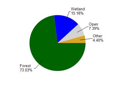
Sand Lake is located in the Lower Namekagon River watershed which is 239.34 mi². Land use in the watershed is primarily forest (73.10%), wetland (15.20%) and a mix of open (7.40%) and other uses (4.40%). This watershed has 172.53 stream miles, 12,590.30 lake acres and 21,781.64 wetland acres.
Nonpoint Source Characteristics
This watershed is ranked Not Ranked for runoff impacts on streams, Not Ranked for runoff impacts on lakes and Low for runoff impacts on groundwater and therefore has an overall rank of Low. This value can be used in ranking the watershed or individual waterbodies for grant funding under state and county programs.However, all waters are affected by diffuse pollutant sources regardless of initial water quality. Applications for specific runoff projects under state or county grant programs may be pursued. For more information, go to surface water program grants.