Douglas
No
No
Yes
Fish and Aquatic Life
Overview
This stream is a small and at least partly intermittent drainage feeder to Allouez Bay of the St. Louis River and has variable and seasonal flows. It was classified as a limited forage fishery. It previously received treated effluent from the Douglas County Hospital. This discharge no longer occurs and through the revision process of the NR104 listing of variance waters will be removed from the list of waters not expected to achieve standards for fishable, swimmable waters. Until otherwise formally classified, this stream should be assumed to meet fish and aquatic life uses. Bear Creek receives a discharge fro the Chicago and Northwestern Transport Co. Itasca Yard, via a drainage ditch. The mouth of Bear Creek is an important spawning area for northern pike and many other warm water species (Pratt 1996).
Descripton partially from: Turville-Heitz, Meg. 1999. Lake Superior Basin Water Quality Management Plan. Wisconsin Department of Natural Resources, Madison, WI.
Date 1999
Author Cordell Manz
General Condition
Bear Creek is a small tributary to Allouez Bay of Lake Superior (or St. Louis River). Located on the southeast side of Superior, it has variable and seasonal flow levels, with its upper reaches being potentially intermittent at times. It had previously been classified as a limited forage fishery (LFF); however, the mouth of Bear Creek is an important spawning area for northern pike and many other warm water species (Pratt 1996), so a more appropriate classification of Bear Creek from its mouth upstream to U.S. Hwy 2/53 (river mile 1.3) would be as a warmwater sport fishery (WWSF). From U.S. Hwy 2/53 upstream, its current and attainable use would be most appropriately classified as a warmwater forage fish (WWFF) community. An unnamed tributary (WBIC 2834800) to Bear Creek that enters from the west side downstream of County Hwy Z would most appropriately be classified a LFF.
Preliminary results from 303d assessment in the Bear Creek watershed in 2009 suggest it could be impaired for degraded habitat as well as high turbidity. HBI ratings from invertebrate sampling in 2009 resulted in fair to fairly poor HBI scores (n = 3; range = 6.1 to 6.8). Limited water chemistry (sampling also resulted in high phosphorous levels that exceeded 0.10 mg/l (n = 5; range = 0.13 to 0.16 mg/l; mean = 0.14 mg/l). Future monitoring should be a priority. Bear Creek does receive a discharge from the Chicago and Northwestern Transport Co. Itasca Yard via a drainage ditch (Lake Superior Basin Water Quality Management Plan, WDNR, 1999).
Date 2010
Author Cordell Manz
Impaired Waters
The 2018 assessments of Bear Creek showed impairment by phosphorus; new total phosphorus sample data exceeded the 2018 WisCALM listing criteria for the Fish and Aquatic Life use. However, available biological data did not indicate impairment (i.e. no macroinvertebrate or fish Index of Biotic Integrity (IBI) scored in the "poor" condition category). Based on the most updated information, this water was proposed for the impaired waters list.
Date 2017
Author Ashley Beranek
Condition
Wisconsin has over 84,000 miles of streams, 15,000 lakes and milllions of acres of wetlands. Assessing the condition of this vast amount of water is challenging. The state's water monitoring program uses a media-based, cross-program approach to analyze water condition. An updated monitoring strategy (2015-2020) is now available. Compliance with Clean Water Act fishable, swimmable standards are located in the Executive Summary of Water Condition in 2018. See also the 'monitoring and projects' tab.
Reports
Recommendations
Restore Wetlands
Restore Wetlands
Restore Wetlands
Restore Wetlands
Monitor Targeted Area
Further monitoring is recommended to conclusively determine the status of Bear Creek with regard to whether it is meeting appropriate fish and aquatic life uses, and whether Bear Creek should be included on the 303(d) list. Monitoring is currently planned for 2010-11 with sampling efforts to include monitoring for potential habitat and turbidity (sedimentation/TSS) impairments, and also phosphorus levels.
Management Goals
Wisconsin's Water Quality Standards provide qualitative and quantitative goals for waters that are protective of Fishable, Swimmable conditions [Learn more]. Waters that do not meet water quality standards are considered impaired and restoration actions are planned and carried out until the water is once again fishable and swimmable
Management goals can include creation or implementation of a Total Maximum Daily Load analysis, a Nine Key Element Plan, or other restoration work, education and outreach and more. If specific recommendations exist for this water, they will be displayed below online.
Monitoring
Monitoring the condition of a river, stream, or lake includes gathering physical, chemical, biological, and habitat data. Comprehensive studies often gather all these parameters in great detail, while lighter assessment events will involve sampling physical, chemical and biological data such as macroinvertebrates. Aquatic macroinvertebrates and fish communities integrate watershed or catchment condition, providing great insight into overall ecosystem health. Chemical and habitat parameters tell researchers more about human induced problems including contaminated runoff, point source dischargers, or habitat issues that foster or limit the potential of aquatic communities to thrive in a given area. Wisconsin's Water Monitoring Strategy was recenty updated.
Grants and Management Projects
Monitoring Projects
| WBIC | Official Waterbody Name | Station ID | Station Name | Earliest Fieldwork Date | Latest Fieldwork Date | View Station | View Data |
|---|
| 2834600 | Bear Creek | 10029778 | Bear Creek at CTH Z | 5/11/2009 | 1/1/2015 | Map | Data |
| 2834600 | Bear Creek | 10029779 | Bear Creek NE of Hwy 2/53 | 9/22/2007 | 7/6/2018 | Map | Data |
| 2834600 | Bear Creek | 10038884 | Bear Creek US of CTH Z | 9/20/2007 | 10/10/2018 | Map | Data |
| 2834600 | Bear Creek | 10034047 | Allouez Bay Macro & Water Quality 2 - Bear Creek Mouth | | | Map | Data |
| 2834600 | Bear Creek | 10029156 | Mouth of Bear Creek - Allouez Bay | 9/5/2008 | 9/5/2008 | Map | Data |
| 2834600 | Bear Creek | 10048234 | Bear Creek upstream Hwy 2/53 | 5/3/2017 | 8/6/2025 | Map | Data |
| 2834600 | Bear Creek | 10015470 | Bear Creek- Upstream City Limits Rd- Station #1 | 9/29/2007 | 1/1/2015 | Map | Data |
| 2834600 | Bear Creek | 10048912 | Allouez Bay Bear Creek Wetland (Station 10048912) | 8/7/2017 | 8/28/2017 | Map | Data |
|
Watershed Characteristics
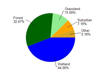
Bear Creek is located in the St. Louis and Lower Nemadji River watershed which is 159.67 mi². Land use in the watershed is primarily wetland (44.10%), forest (32.50%) and a mix of grassland (11.10%) and other uses (12.40%). This watershed has 432.66 stream miles, 8,490.75 lake acres and 26,945.85 wetland acres.
Nonpoint Source Characteristics
This watershed is ranked Not Ranked for runoff impacts on streams, Not Available for runoff impacts on lakes and Low for runoff impacts on groundwater and therefore has an overall rank of Low. This value can be used in ranking the watershed or individual waterbodies for grant funding under state and county programs.However, all waters are affected by diffuse pollutant sources regardless of initial water quality. Applications for specific runoff projects under state or county grant programs may be pursued. For more information, go to surface water program grants.