")
8.55 Miles
0 - 8.55
Macroinvertebrate, Coldwater
2021
Good
Douglas
No
No
No
Fish and Aquatic Life
Overview
The Pokegama River originates just across the Wisconsin/Minnesota border near Jay Cooke State Park in Minnesota and flows in an eastern direction before turning north near Wisconsin State Hwy 35. The Pokegama River is nearly twentysix miles in length, while the Little Pokegama River is only about eight-miles long and flows just north and west of the Pokegama River and is also tributary to the St. Louis River, with its confluence located at the upstream end of Spirit Lake. The headwater areas of the Pokegama and Little Pokegama River are associated with the Pokegama-Carnegie wetlands, which have been identified by the Wisconsin Department of Natural Resources (WDNR) Bureau of Endangered Resources as a Lake Superior Basin Priority Site. This high quality wetland is an extensive area of poorly drained, red clay flats comprised of shrub swamp, sedge meadow, emergent marsh, small ponds, and is punctuated with tiny upland “islets” consisting of white spruce, white and red pine, balsam poplar, and trembling aspen (Lake Superior Basin Water Quality Management Plan, WDNR, 1999).
The Little Pokegama River had a baseline monitoring survey conducted at State Hwy 105 in 2006 which suggest the current use of the Little Pokegama could be as WWFF. Given habitat and water quality present, the best attainable use designation for the Little Pokegama may be as a WWFF also; presently, its current and attainable use is listed as “unknown”
Date 2009
Author Nancy Larson
Condition
Wisconsin has over 84,000 miles of streams, 15,000 lakes and milllions of acres of wetlands. Assessing the condition of this vast amount of water is challenging. The state's water monitoring program uses a media-based, cross-program approach to analyze water condition. An updated monitoring strategy (2015-2020) is now available. Compliance with Clean Water Act fishable, swimmable standards are located in the Executive Summary of Water Condition in 2018. See also the 'monitoring and projects' tab.
Reports
Recommendations
Monitor Fish Community
AU 17469, poor fIBI, Station 10015473
Monitor for Use Designation
Condition monitoring and evaluation of the Pokegama River, Little Pokegama River, and tributary streams for most
appropriate current, attainable, and designated use categories throughout both stream watersheds is recommended. [09/10]
Management Goals
Wisconsin's Water Quality Standards provide qualitative and quantitative goals for waters that are protective of Fishable, Swimmable conditions [Learn more]. Waters that do not meet water quality standards are considered impaired and restoration actions are planned and carried out until the water is once again fishable and swimmable
Management goals can include creation or implementation of a Total Maximum Daily Load analysis, a Nine Key Element Plan, or other restoration work, education and outreach and more. If specific recommendations exist for this water, they will be displayed below online.
Monitoring
Monitoring the condition of a river, stream, or lake includes gathering physical, chemical, biological, and habitat data. Comprehensive studies often gather all these parameters in great detail, while lighter assessment events will involve sampling physical, chemical and biological data such as macroinvertebrates. Aquatic macroinvertebrates and fish communities integrate watershed or catchment condition, providing great insight into overall ecosystem health. Chemical and habitat parameters tell researchers more about human induced problems including contaminated runoff, point source dischargers, or habitat issues that foster or limit the potential of aquatic communities to thrive in a given area. Wisconsin's Water Monitoring Strategy was recenty updated.
Grants and Management Projects
Monitoring Projects
| WBIC | Official Waterbody Name | Station ID | Station Name | Earliest Fieldwork Date | Latest Fieldwork Date | View Station | View Data |
|---|
| 2845200 | Little Pokegama River | 10015473 | Little Pokegama River- Upstream Hwy 105- Station #1 | 5/17/2012 | 7/14/2021 | Map | Data |
| 2845200 | Little Pokegama River | 163207 | Little Pokegama River - 3 Mi So Hwy 105 | 4/29/1980 | 4/29/1980 | Map | Data |
|
Watershed Characteristics
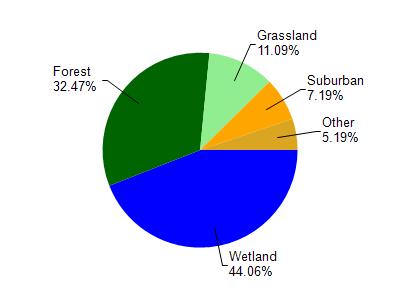
Little Pokegama River is located in the St. Louis and Lower Nemadji River watershed which is 159.67 mi². Land use in the watershed is primarily wetland (44.10%), forest (32.50%) and a mix of grassland (11.10%) and other uses (12.40%). This watershed has 432.66 stream miles, 8,490.75 lake acres and 26,945.85 wetland acres.
Nonpoint Source Characteristics
This watershed is ranked Not Ranked for runoff impacts on streams, Not Available for runoff impacts on lakes and Low for runoff impacts on groundwater and therefore has an overall rank of Low. This value can be used in ranking the watershed or individual waterbodies for grant funding under state and county programs.However, all waters are affected by diffuse pollutant sources regardless of initial water quality. Applications for specific runoff projects under state or county grant programs may be pursued. For more information, go to surface water program grants.
Little Pokegema River is considered a Macroinvertebrate, Coldwater under the state's Natural Community Determinations.
Natural communities (stream and lake natural communities) represent model results and DNR staff valiation processes that confirm or update predicted conditions based on flow and temperature modeling from historic and current landscape features and related variables. Predicated flow and temperatures for waters are associated predicated fish assemblages (communities). Biologists evaluate the model results against current survey data to determine if the modeled results are corect and whether biological indicators show water quaity degradation. This analysis is a core component of the state's resource management framework. Wisconsin's Riverine Natural Communities.