Adams
No
No
No
Fish and Aquatic Life
Overview
Patrick Lake is a 50-acre mesotrophic/oligotrophic lake with good-to-very good water quality and good water clarity. Water clarity has decreased since 1983. Filamentous algae is common to abundant throughout Patrick Lake.
The Patrick Lake aquatic plant community colonized approximately three-quarters of the entire lake area to a maximum rooting depth of 13 feet. Within the important shallow water littoral zone, Patrick Lake, 100% of the sites were vegetated. The 0-1.5ft depth zone supported the most abundant aquatic plant growth. The aquatic plant community is characterized by high quality, good species diversity, an average sensitivity to disturbance and a condition closer than average to an undisturbed condition.
Patrick Lake is a 50-acre seepage lake in southeast Adams County, Wisconsin. Patrick Lake has a maximum depth of 21 feet and a mean depth of 10 feet.
Complaints about aquatic plant growth started in 1957. The first chemical treatments started in 1958, using arsenic, a very toxic substance that does not degrade, but remains in the sediments.
An assessment of the lake was conducted in 1978 by DNR staff due to complaints concerning plant growth. Najas spp, was the most abundant species. Myriophyllum spp., Potamogeton nodosus and P. richardsonii were common; Chara was present; Brasenia and Nymphaea occurred in one area.
At some point Eurasian watermilfoil was introduced into Patrick Lake; its introduction and spread may have been facilitated by broad spectrum treatments in the past that opened up areas for colonization of the exotic species. By 2004, Eurasian watermilfoil had colonized about 17-acres of the lake (Cason and Roost 2004) (Appendix IX). Herbicide treatments for controlling the Eurasian watermilfoil were conducted in spring 2005 (Table 1). The July 2005 survey did not find any Eurasian watermilfoil, but new colonies could resprout. A 0.5-acre area was found and treated in September 2005. Residents need to be watchful of new Eurasian watermilfoil colonies for several years.
Date 2006
Author Aquatic Biologist
Historical Description
Source: 1966, Surface Water Resources of Adams County Patrick Lake, T16N, R7E, Section 9 Surface Acres = 47.5, S.D.F.= 1.77, Maximum Depth = 10 feet.
A hard water seepage lake that has clear water, is alkaline, and has a moderate transparency. This lake has had periodicwinterkills but between times it is managed for northern pike, largemouth bass, and bluegills. An abundance of aquatic vegetation and a fluctuating, but generally declining water level are the major use problems. Public access, including an unimproved boat landing, is present. There are 18 dwellings and one youth camp located on the lake. Marl was reportedly removed from this lake many years ago. Waterfowl make use of the lake during spring and fall.
Date 1966
Author Surface Water Inventory Of Wisconsin
Condition
Wisconsin has over 84,000 miles of streams, 15,000 lakes and milllions of acres of wetlands. Assessing the condition of this vast amount of water is challenging. The state's water monitoring program uses a media-based, cross-program approach to analyze water condition. An updated monitoring strategy (2015-2020) is now available. Compliance with Clean Water Act fishable, swimmable standards are located in the Executive Summary of Water Condition in 2018. See also the 'monitoring and projects' tab.
Reports
Recommendations
Monitor Water Quality or Sediment
Insufficient TP data to make assessment. Further TP monitoring recommended.
Lake Classification
Adams County proposes to wrap up its county-wide lake classification effort. Major project elements to include: 1) completion of water sampling, 2) development of lakes classification report and individual lake summaries, 3) development of a powerpoint presentation, 4) four public meetings, 5) expansion of shoreline restoration packet.
Lake Classification
Adams County continue its lake classification efforts through collecting and assessing chemical and biological data on all lakes within the county that afford public access. Major project componants to include: 1) collection and assessment of chemical and biological data, 2) development of a "library" of information for public use, 3) development of management recommendations, 4) I&E for riparians and lake users.
Lake Classification
Adams County proposes to initiate a Lakes Classification effort to assist in comprehensive plan development for communities surrounding its lakes with public access. Phase 1 elements, to be funded with this grant, include: 1) delination of surface watersheds and flow patterns, 2) delineation of ground watersheds, 3) identification and mapping of land uses, 4) inventory and mapping of shoreline erosion and development problems, 5) identification and mapping of sensitive/critical areas and natural heritage habitats, 6) verification of wetland delineations, 7) delineations of lake watersheds, 8) development of lake maps
Management Goals
Wisconsin's Water Quality Standards provide qualitative and quantitative goals for waters that are protective of Fishable, Swimmable conditions [Learn more]. Waters that do not meet water quality standards are considered impaired and restoration actions are planned and carried out until the water is once again fishable and swimmable
Management goals can include creation or implementation of a Total Maximum Daily Load analysis, a Nine Key Element Plan, or other restoration work, education and outreach and more. If specific recommendations exist for this water, they will be displayed below online.
Monitoring
Monitoring the condition of a river, stream, or lake includes gathering physical, chemical, biological, and habitat data. Comprehensive studies often gather all these parameters in great detail, while lighter assessment events will involve sampling physical, chemical and biological data such as macroinvertebrates. Aquatic macroinvertebrates and fish communities integrate watershed or catchment condition, providing great insight into overall ecosystem health. Chemical and habitat parameters tell researchers more about human induced problems including contaminated runoff, point source dischargers, or habitat issues that foster or limit the potential of aquatic communities to thrive in a given area. Wisconsin's Water Monitoring Strategy was recenty updated.
Grants and Management Projects
Monitoring Projects
| WBIC | Official Waterbody Name | Station ID | Station Name | Earliest Fieldwork Date | Latest Fieldwork Date | View Station | View Data |
|---|
| 106600 | Patrick Lake | 10018043 | Patrick Lake -- Access | 6/22/2012 | 6/22/2012 | Map | Data |
| 106600 | Patrick Lake | 10040944 | Patrick Lake - Monitoring Well | 5/1/2013 | 9/5/2015 | Map | Data |
| 106600 | Patrick Lake | 10000522 | Patrick Lake | 8/15/1983 | 8/25/2020 | Map | Data |
| 106600 | Patrick Lake | 013051 | Patrick Lake - Maximum Depth | 6/4/1986 | 6/9/2026 | Map | Data |
| 106600 | Patrick Lake | 10017317 | Patrick Lake - Beach 386 Eagle Dr. Grand Marsh | | | Map | Data |
| 106600 | Patrick Lake | 10048478 | Patrick Lake - Staff Gage | | | Map | Data |
|
Watershed Characteristics
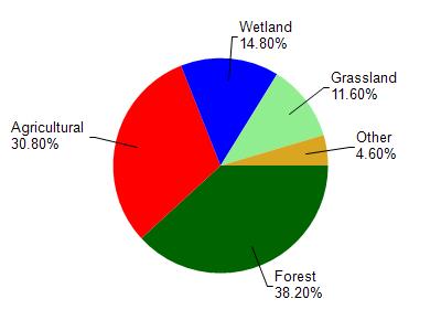
Patrick Lake is located in the Neenah Creek watershed which is 173.35 mi². Land use in the watershed is primarily forest (38.20%), agricultural (30.80%) and a mix of wetland (14.80%) and other uses (16.20%). This watershed has 198.75 stream miles, 2,104.14 lake acres and 14,499.98 wetland acres.
Nonpoint Source Characteristics
This watershed is ranked Not Available for runoff impacts on streams, Not Ranked for runoff impacts on lakes and High for runoff impacts on groundwater and therefore has an overall rank of High. This value can be used in ranking the watershed or individual waterbodies for grant funding under state and county programs.However, all waters are affected by diffuse pollutant sources regardless of initial water quality. Applications for specific runoff projects under state or county grant programs may be pursued. For more information, go to surface water program grants.