Sheboygan
No
No
Yes
Fish and Aquatic Life
Overview
OTTER CREEK, SHEBOYGAN COUNTY
T15N R22E Sec. 7 NWNW Stream Length = 4.2 WBIC = 56400
Otter Creek, which originates at the outlet of a small privately owned spring lake, is 4.2 miles long, drains about 11 square miles and has an average gradient of 12.4 feet per mile. It flows southeast for a quarter mile through a white cedar and tamarack swamp until entering an area dominated by agriculture. The main stem of Otter Creek receives additional flow from the Gerber Lake outlet about 0.75 miles from its headwaters, and also from Little Elkhart Lake through a human-made outlet at the headwaters.
Otter Creek is the site of three major interrelated studies involving polluted runoff. The U.S. Geological Survey and WDNR have established a Whole Stream Monitoring site on Otter Creek at Willow Road which provides continuous monitoring of flow, dissolved oxygen, and temperature, along with storm flow monitoring. The DNR Bureau of Research is also using Otter Creek to fine tune the index of biotic integrity (IBI) so it will be more useful when making management decisions regarding sources of polluted runoff. Southeast Region DNR has also used Otter Creek to evaluate the performance of nonpoint source best management practices on sources of polluted runoff. The study involved three years of intensive evaluation monitoring to establish baseline data from which the effectiveness of the Nonpoint Source Pollution Abatement program could be determined. In addition, data were collected throughout the five-year implementation phase of the controls and collected for three years after implementation to track effectiveness.
An overview of the water quality of Otter Creek is presented here. Numerous publications have resulted from these nonpoint source evaluation monitoring studies and the reader is encouraged to examine these reports for additional information (e.g. Wierl et al. 1996, Wang et al. 1996, Rappold et al. 1997, Corsi et al. 1997, and Stuntebeck and Bannerman 1998). Otter Creek has a limited sport fish community, and diverse, relatively abundant forage fish community including species tolerant and very tolerant of pollution and degraded habitat. Although intolerant forage species are present, they are represented by fewer species and are less abundant. Northern pike from the Sheboygan River have been reported to use the stream and adjacent wetlands for spawning. Hilsenhoff biotic index (HBI) values from macroinvertebrate samples indicate good to fair water quality with respect to organic forms of pollution. The creek is only partially meeting its biological use potential for supporting a warm water forage fish community. Factors preventing Otter Creek from meeting its full potential include loss of in-stream and riparian habitat, excessive algae growth, and high concentrations of bacteria. Sources responsible include erosion from uplands and banks, streambank pasturing, livestock access to the stream, channelization, barnyard runoff and failing septic systems. Excessive sedimentation may reduce fish production because of loss of cover, poor spawning substrate, and the presence of few fish food organisms.
Date 2001
Author Aquatic Biologist
Overview
OTTER CREEK, SHEBOYGAN COUNTY - T15N R22E Sec. 7, Stream Length = 4.2.
Otter Creek, which originates at the outlet of a small privately owned spring lake, is 4.2 miles long, drains about 11 square miles and has an average gradient of 12.4 feet per mile. It flows southeast for a quarter mile through a white cedar and tamarack swamp until entering an area dominated by agriculture. The main stem of Otter Creek receives additional flow from the Gerber Lake outlet about 0.75 miles from its headwaters, and also from Little Elkhart Lake through a human-made outlet at the headwaters.
Otter Creek is the site of three major interrelated studies involving polluted runoff. The U.S. Geological Survey and WDNR have established a Whole Stream Monitoring site on Otter Creek at Willow Road which provides continuous monitoring of flow, dissolved oxygen, and temperature, along with storm flow monitoring. The DNR Bureau of Research is also using Otter Creek to fine tune the index of biotic integrity (IBI) so it will be more useful when making management decisions regarding sources of polluted runoff. Southeast Region DNR has also used Otter Creek to evaluate the performance of nonpoint source best management practices on sources of polluted runoff. The study involved three years of intensive evaluation monitoring to establish baseline data from which the effectiveness of the Nonpoint Source Pollution Abatement program could be determined. In addition, data were collected throughout the five-year implementation phase of the controls and collected for three years after implementation to track effectiveness.
An overview of the water quality of Otter Creek is presented here. Numerous publications have resulted from these nonpoint source evaluation monitoring studies and the reader is encouraged to examine these reports for additional information (e.g. Wierl et al. 1996, Wang et al. 1996, Rappold et al. 1997, Corsi et al. 1997, and Stuntebeck and Bannerman 1998). Otter Creek has a limited sport fish community, and diverse, relatively abundant forage fish community including species tolerant and very tolerant of pollution and degraded habitat. Although intolerant forage species are present, they are represented by fewer species and are less abundant. Northern pike from the Sheboygan River have been reported to use the stream and adjacent wetlands for spawning. Hilsenhoff biotic index (HBI) values from macroinvertebrate samples indicate good to fair water quality with respect to organic forms of pollution. The creek is only partially meeting its biological use potential for supporting a warm water forage fish community. Factors preventing Otter Creek from meeting its full potential include loss of in-stream and riparian habitat, excessive algae growth, and high concentrations of bacteria. Sources responsible include erosion from uplands and banks, streambank pasturing, livestock access to the stream, channelization, barnyard runoff and failing septic systems. Excessive sedimentation may reduce fish production because of loss of cover, poor spawning substrate, and the presence of few fish food organisms.
Freshwater mussels are particularly sensitive to human induced changes in watersheds and are often used as one of many biological monitoring tools to assess the condition of the resource. WDNR conducted quantitative mussel surveys using the Random Point method in the Otter Creek subwatershed at sites where water chemistry, habitat, fish and macroinvertebrate data have been collected (Galarneau 1998). A population of the State Threatened Species slippershell mussel (Alasmidonta viridis) was found in the Otter Creek subwatershed. Specific collection sites are not reported for environmentally sensitive species (Endangered, Threatened, or Special Concern).
From: Galarneau, Steve and Masterson, John. 1999. Water Resources of the Sheboygan River Basin. Wisconsin Department of Natural Resources, Madison, WI.
Date 1999
Author Aquatic Biologist
General Condition
Hydrologic, water-quality, habitat, and fish data were collected at Otter Creek from 1990 to 2002 with the pre-BMP (best-management practice) period ending in September 1993 and the post-BMP period beginning in October 1999. BMPs installed in this basin included streambank protection and fencing, stream crossings, grade stabilization, buffer strips, various barnyard-runoff controls, nutrient management, and a low degree of upland BMPs. Reductions between pre- and post-BMP periods were detected in median concentrations of base-flow samples for total suspended solids and BOD5 but not for total phosphorus or dissolved ammonia nitrogen; fecal coliform concentrations in base-flow samples increased over the study period.
Date 2013
Author Steve Corsi
Condition
Wisconsin has over 84,000 miles of streams, 15,000 lakes and milllions of acres of wetlands. Assessing the condition of this vast amount of water is challenging. The state's water monitoring program uses a media-based, cross-program approach to analyze water condition. An updated monitoring strategy (2015-2020) is now available. Compliance with Clean Water Act fishable, swimmable standards are located in the Executive Summary of Water Condition in 2018. See also the 'monitoring and projects' tab.
Reports
Recommendations
Monitor to Evaluate Projects
determine if the water quality of Otter Creek has improved after the implementation of best management practices
Management Goals
Wisconsin's Water Quality Standards provide qualitative and quantitative goals for waters that are protective of Fishable, Swimmable conditions [Learn more]. Waters that do not meet water quality standards are considered impaired and restoration actions are planned and carried out until the water is once again fishable and swimmable
Management goals can include creation or implementation of a Total Maximum Daily Load analysis, a Nine Key Element Plan, or other restoration work, education and outreach and more. If specific recommendations exist for this water, they will be displayed below online.
Monitoring
Monitoring the condition of a river, stream, or lake includes gathering physical, chemical, biological, and habitat data. Comprehensive studies often gather all these parameters in great detail, while lighter assessment events will involve sampling physical, chemical and biological data such as macroinvertebrates. Aquatic macroinvertebrates and fish communities integrate watershed or catchment condition, providing great insight into overall ecosystem health. Chemical and habitat parameters tell researchers more about human induced problems including contaminated runoff, point source dischargers, or habitat issues that foster or limit the potential of aquatic communities to thrive in a given area. Wisconsin's Water Monitoring Strategy was recenty updated.
Grants and Management Projects
Monitoring Projects
| WBIC | Official Waterbody Name | Station ID | Station Name | Earliest Fieldwork Date | Latest Fieldwork Date | View Station | View Data |
|---|
| 56400 | Otter Creek | 603326 | Otter Creek - Willow Rd Oc008 | 8/21/1991 | 6/10/1999 | Map | Data |
| 56400 | Otter Creek | 10010634 | Otter Creek | | | Map | Data |
| 56400 | Otter Creek | 603491 | Otter Creek at Cth J | | | Map | Data |
| 56400 | Otter Creek | 603320 | Otter Creek - Green Tree Rd Oc002 | 4/19/1988 | 1/1/2015 | Map | Data |
| 56400 | Otter Creek | 603316 | Otter Creek at Willow Rd Near Plymouth WI | 4/19/1988 | 1/6/2016 | Map | Data |
| 56400 | Otter Creek | 10010378 | Otter Creek - Otter Creek1atSth 57 (~480m Upstream) | 11/4/2011 | 10/22/2015 | Map | Data |
| 56400 | Otter Creek | 603323 | Otter Creek - Cth J Oc005 | 8/21/1991 | 6/10/1999 | Map | Data |
| 56400 | Otter Creek | 10010636 | Otter Creek | | | Map | Data |
| 56400 | Otter Creek | 10033779 | Otter Creek - Upstream of Willow Road | 11/4/2011 | 10/22/2015 | Map | Data |
| 56400 | Otter Creek | 603328 | Otter Creek Site #2 at Cth J Near Plymouth WI | 8/29/1991 | 10/11/1994 | Map | Data |
| 56400 | Otter Creek | 603216 | Otter Creek at Willow Road | 8/17/1978 | 8/17/1978 | Map | Data |
| 56400 | Otter Creek | 603319 | Otter Creek - Cth E Oc001 | 10/29/1987 | 1/1/2015 | Map | Data |
| 56400 | Otter Creek | 10033733 | Otter Creek - S of Green Tree Road | 6/14/2011 | 10/22/2015 | Map | Data |
| 56400 | Otter Creek | 603332 | Otter Creek Tributary Site #6 at Cth E Near Plymouth WI | | | Map | Data |
| 56400 | Otter Creek | 603344 | Otter Creek at Laack Farm Near Plymouth WI | 10/29/1987 | 1/1/2015 | Map | Data |
| 56400 | Otter Creek | 603345 | Otter Creek Site #3a at Cth J Near Plymouth WI | 10/29/1987 | 1/1/2015 | Map | Data |
| 56400 | Otter Creek | 603321 | Otter Creek - Sth 57 Oc003 | 7/18/1950 | 1/1/2015 | Map | Data |
| 56400 | Otter Creek | 603331 | Otter Creek Site #5 at Green Tree Rd Near Plymouth WI | 7/27/1993 | 8/24/1993 | Map | Data |
| 56400 | Otter Creek | 10010637 | Otter Creek | | | Map | Data |
| 56400 | Otter Creek | 10010633 | Otter Creek - 5 | | | Map | Data |
| 56400 | Otter Creek | 603330 | Otter Creek Tributary Site #4 at Sth 57 Near Plymouth WI | 7/27/1993 | 8/29/2011 | Map | Data |
| 56400 | Otter Creek | 603327 | Otter Creek Tributary Site #1 at Cth J Near Plymouth WI | 7/27/1993 | 4/7/1994 | Map | Data |
| 56400 | Otter Creek | 603329 | Otter Creek Site #3 at Sth 57 Near Plymouth WI | | | Map | Data |
| 56400 | Otter Creek | 10010635 | Otter Creek - 3 | | | Map | Data |
|
Watershed Characteristics
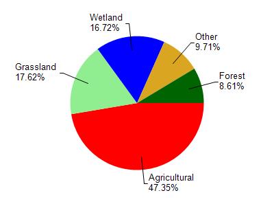
Otter Creek is located in the Sheboygan River watershed which is 260.12 mi². Land use in the watershed is primarily agricultural (47.30%), grassland (17.60%) and a mix of wetland (16.70%) and other uses (18.30%). This watershed has 340.24 stream miles, 4,345.33 lake acres and 27,968.05 wetland acres.
Nonpoint Source Characteristics
This watershed is ranked Not Available for runoff impacts on streams, Not Available for runoff impacts on lakes and High for runoff impacts on groundwater and therefore has an overall rank of High. This value can be used in ranking the watershed or individual waterbodies for grant funding under state and county programs.However, all waters are affected by diffuse pollutant sources regardless of initial water quality. Applications for specific runoff projects under state or county grant programs may be pursued. For more information, go to surface water program grants.