Dane
No
No
No
Fish and Aquatic Life
Overview
Rock River Water Quality Management Plan, Lower Rock River Appendix. WT-668-2002. South Central Region, WDNR.
The Stoughton Millpond is a shallow impoundment of the Yahara River. It has a surface area of 82 acres and a maximum depth of 5 feet. The majority of the millpond lies within the Stoughton city limits. The surrounding land is dominated by agriculture to the north and municipal and residential areas to the south. Non-point source pollution and urban stormwater runoff negatively impair the millpond. No major wetlands border the lake, but several small sedge and grass meadows provide limited habitat for waterfowl and muskrats. The lake bottom is mostly clay with sand, silt, and some detritus present as well. With the exception of cattail stands on the lake’s east side, macrophytes are scarce as a result of the large carp population. The water is turbid, alkaline, and shows signs of eutrophication. Nuisance algae growths are common.
The Stoughton Millpond supports a diverse warm water fishery, and fish species include northern pike, common carp, bluntnose minnow, buffalo (unsp.), white sucker, black, yellow and brown bullhead, brook silverside, green sunfish, pumpkinseed, bluegill, largemouth bass, white and black crappie, johnny darter, yellow perch, walleye, and freshwater drum. Access is available at Stoughton and from the Yahara River by way of Viking County Park just north of the lake.
The Stoughton Dam is located in the City of Stoughton, which owns and operates it. Built in 1843, the spillway was washed out following a large storm in 1915 that also caused the Dunkirk and Stebbinsville dams to fail and was re-built the following year. The Stoughton dam generated power until the summer of 1999. The City of Stoughton would need to apply for a federal license if they elect to generate electricity again.
The dam is 520 feet long and 14.3 feet high with a normal hydraulic height (difference between headwater and tailwater) of 9 feet and dam creates a long, narrow impoundment lined with many landowners. The maximum storage capacity is 108 acre-feet, which can handle a flood of 2-1/2 times the magnitude of the 100-year flood. The dam must pass 15 cubic feet of water per second, which is the seven-day low flow with a ten-year recurrence interval on the Yahara River. The maximum water level is 842 feet and the minimum is 841 feet. The dam appears to need of only minor repairs but has not been inspected recently.
Date 2002
Author Aquatic Biologist
Condition
Wisconsin has over 84,000 miles of streams, 15,000 lakes and milllions of acres of wetlands. Assessing the condition of this vast amount of water is challenging. The state's water monitoring program uses a media-based, cross-program approach to analyze water condition. An updated monitoring strategy (2015-2020) is now available. Compliance with Clean Water Act fishable, swimmable standards are located in the Executive Summary of Water Condition in 2018. See also the 'monitoring and projects' tab.
Recommendations
Lake Classification
Dane County Lake Classification-Phase 2: The Phase 1 classification grant classified all county lakes and streams. This grant will take the next step by developing a management program based on the classification.
Lake Classification
Dane County Department of Planning and Development will hire a project staff in order to develop a Lake Classification project, which is seen as the first step toward developing a consistent set of county-wide standards and procedures to protect Dane County Waters.
Rivers Management Grant
Stoughton is proposing to improve its river environment, promote recreational and business activities on and along the river, and improve the communities' understanding of the economic value of the Yahara River. The primary goals and objectives of the river planning project will be to define demographic characteristics of the public users of the City's waterfront areas and ecologically sensitive improvements to these areas that promote use and also provide economic advantages for the City and its waterfront businesses. Another goal is to create a coordinated approach to protecting the river using existing river organizations.
Sewer Service Area Planning
The City of Stoughton is requesting amendment to the Stoughton USA. The area is
located at the northwestern corner of the City, abutting Town of Dunn, Town of
Dunkirk, and Town of Rutland. The majority of the area is currently within the City.
Three town islands currently exist in the amendment area: a roughly 1.5-acre parcel
in the Town of Rutland and two parcels totaling around 14 acres in the Town of
Dunkirk. The amendment area is split in half by USH 51. Existing land use is
primarily agriculture, woodlands, other open lands, and single-family. Proposed land
use to the east of USH 51 includes large-scale multi-family and duplex residential,
open space/park, and stormwater management. Proposed uses immediately west of
USH 51 include commercial and stormwater management, while large and small-scale
multi-family residential, single-family residential, open space/park, and stormwater
management uses are proposed further west.
Management Goals
Wisconsin's Water Quality Standards provide qualitative and quantitative goals for waters that are protective of Fishable, Swimmable conditions [Learn more]. Waters that do not meet water quality standards are considered impaired and restoration actions are planned and carried out until the water is once again fishable and swimmable
Management goals can include creation or implementation of a Total Maximum Daily Load analysis, a Nine Key Element Plan, or other restoration work, education and outreach and more. If specific recommendations exist for this water, they will be displayed below online.
Monitoring
Monitoring the condition of a river, stream, or lake includes gathering physical, chemical, biological, and habitat data. Comprehensive studies often gather all these parameters in great detail, while lighter assessment events will involve sampling physical, chemical and biological data such as macroinvertebrates. Aquatic macroinvertebrates and fish communities integrate watershed or catchment condition, providing great insight into overall ecosystem health. Chemical and habitat parameters tell researchers more about human induced problems including contaminated runoff, point source dischargers, or habitat issues that foster or limit the potential of aquatic communities to thrive in a given area. Wisconsin's Water Monitoring Strategy was recenty updated.
Grants and Management Projects
Monitoring Projects
| WBIC | Official Waterbody Name | Station ID | Station Name | Earliest Fieldwork Date | Latest Fieldwork Date | View Station | View Data |
|---|
| 798300 | Yahara River | 133226 | Stoughton Water Dist | 1/20/1982 | 1/20/1982 | Map | Data |
| 802000 | Stoughton Millpond 429 | 10001235 | Stoughton Millpond | 7/27/1999 | 7/17/2010 | Map | Data |
| 802000 | Stoughton Millpond 429 | 133045 | Yahara River - Uniroyal Rubber Co Outfall | 2/15/1978 | 2/15/1978 | Map | Data |
|
Watershed Characteristics
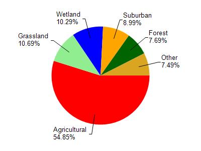
Stoughton Millpond 429 is located in the Yahara River and Lake Kegonsa watershed which is 126.33 mi². Land use in the watershed is primarily agricultural (54.90%), grassland (10.70%) and a mix of wetland (10.30%) and other uses (24.20%). This watershed has 145.73 stream miles, 3,600.04 lake acres and 6,832.19 wetland acres.
Nonpoint Source Characteristics
This watershed is ranked Medium for runoff impacts on streams, Low for runoff impacts on lakes and High for runoff impacts on groundwater and therefore has an overall rank of High. This value can be used in ranking the watershed or individual waterbodies for grant funding under state and county programs.However, all waters are affected by diffuse pollutant sources regardless of initial water quality. Applications for specific runoff projects under state or county grant programs may be pursued. For more information, go to surface water program grants.