Dane
No
No
Yes
Fish and Aquatic Life
Overview
Rock River Water Quality Management Plan, Lower Rock River Appendix. WT-668-2002. South Central Region, WDNR.
The Yahara River flows from Lake Waubesa into Lower Mud Lake. The lake has a surface area of 195 acres and a maximum depth of 15 feet. In addition to river flow, water sources include groundwater discharge by small springs and seepages from the surrounding marsh. Water quality problems exist as a result of heavy nutrient loads carried into the lake by the Yahara River, from direct runoff from adjacent agricultural fields, and from surrounding urban development. Increasing urbanization and development pressure in the Village of McFarland near the lake is responsible for much of the sediments and nutrients deposited into Lower Mud Lake. Occasional low flow conditions in the lake, likely from the diversion of effluent around the Yahara Lakes, exacerbates water quality problems (Fix 2000, personal communication).
The shallow Lower Mud Lake experiences excessive aquatic plant growth and is used extensively by migrating waterfowl. The open water area of Lower Mud Lake, is an extremely important resting area for migrating waterfowl during the spring. Ducks, geese, herons and swans will stop to rest and feed here. Since the water opens early on the river, the area is especially good for early migrating waterfowl. Fast boat traffic, however, degrades established wetland plants and stir bottom sediment, clouding the water, releasing stored nutrients in sediment, and reducing overall lake and wetland functional values.
Evaluations by South Central Region Lake Management and Nonpoint Source staff characterize this lake and its wetlands as threatened and in need of management and protection. In 1996, Dane County and the Village of McFarland received DNR grants to acquire land to protect the lake. This lake would benefit from protection of existing wetlands and enhancement of buffers.
Commonly found fish species include the longnose gar, bowfin, northern pike, common carp, golden shiner, bluntnose and fathead minnow, white sucker, black, brown, and yellow bullhead, channel catfish, brook silverside, white and rock bass, green sunfish, pumpkinseed, bluegill, largemouth bass, white and black crappie, yellow perch, walleye, and freshwater drum. The lake is predominantly a panfish and bass lake and walleye fishing is negligible. Lack of adequate public access to the lake is a problem.
Date 2002
Author Aquatic Biologist
Overview
The Lower Mud Lake Wetlands that surround Lower Mud Lake act to buffer the wetland from surrounding agricultural lands as well as provide a much needed groundwater recharge area and critical fishery and waterfowl habitat. These wetlands are a part of the many large peat deposits along the Yahara River. The Dane County Regional Planning Commission has ranked this wetland as a Priority I, one of the most important in the county for management and protection.
The wetland on the east side of Lower Mud Lake is a sedge meadow on a deep layer of peat and encompasses about 200 acres. The Department of Natural Resources owns 137 of the 200 acres on the east side. The east wetlands provide breeding and feeding habitat areas for the woodcock and snipe. This wetland extends into the Village of McFarland where it is designated as a park and conservancy area. In two places, arms of this wetland extend eastward to connect with the Door Creek wetlands along Lake Kegonsa. Shrubs, trees and reed canary grass are currently invading this area.
A second wetland area is on the west side of Lower Mud Lake. It is about 400 acres in size and fed directly by springs and partially from overland runoff. This area is a deep peat deposit and has more standing water than the east side wetland. Keenan�s Creek flows into the wetland, and there are many springs and seepages discharging groundwater. USH 51 bisects the west wetland. DNR owns approximately 180 acres of land on the west side of Mud Lake. Together the east and west wetlands serve as buffers around Lower Mud Lake and contribute to its value as an isolated wildlife area.
The Tower Road wetland, the third wetland component of the area, is about 100 acres in size and borders Lake Waubesa. This area is similar in character and size to the west side wetland along Mud Lake. It is primarily an emergent wet meadow with some areas of scrub vegetation on wet soils.
The only significant development along Lower Mud Lake is the development of five residential sites on Rivercrest Road, outside of McFarland. Fast boat traffic in Lower Mud Lake impairs wetland plant growth and releases nutrients from the lake sediments reducing the wetland�s functions.
As a major wetland area along the Yahara River, Lower Mud Lake is a significant environmental feature in this watershed. In 1994, Dane County Board of Supervisors adopted the Lower Mud Lake Resource Protection Project Plan prepared by the Dane County Parks Commission and the Dane County Regional Planning Commission. The objectives of the plan are to 1) create a 1,700 acre preserve to protect and restore natural resources such as wetland, floodplain, springs and other related features, 2) provide for and protect natural habitat for fish, waterfowl and wildlife, and 3) preserve archeological and historic resource sites.
These wetlands provide critical fish habitat and spawning grounds for fish in Lower Mud Lake and the Yahara River. Northern Pike move upstream from Lake Kegonsa to spawn in these wetlands. Walleyes are also present in this area during spawning season. Largemouth bass and northern pike are the dominant predator species, while bluegills and black bullheads are the most numerous panfish.
Date 2002
Author Aquatic Biologist
Historical Description
Source: 1985, Surface Water Resources of Dane County,WI: WI-DNR Lower Mud Lake - T6N, R10E, Sec. 10
This shallow lake is located on the Yahara River and is completely encircled by shallow marsh and fresh meadow. Water quality problems are a result of direct runoff from adjacent agricultural lands and the large nutrient load carried by the Yahara River. Shallowness, excessive aquatic vegetation, poor water quality, and lack of good public access limit the recreational value of this lake. Major fish species include panfish and bullheads, though most species common to the Yahara River system are present. A wilderness type access is available through public hunting grounds on the eastern shore and boats may reach the lake by way of the Yahara River. Waterfowl use of this shallow lake is extensive and hunting is good. Fish species: longnose gar, bowfin, northern pike, common carp, golden shiner, bluntnose and fathead minnow, white sucker, black, brown, and yellow bullhead, channel catfish, brook silverside, white and rock bass, green sunfish, pumpkinseed, bluegill, largemouth bass, white and black crappie, yellow perch, walleye, and freshwater drum.
Surface acres = 195, SDF = 1.23, Maximum depth - 15 ft
Date 1985
Author Surface Water Inventory Of Wisconsin
Recommendations
Lake Classification
Dane County Lake Classification-Phase 2: The Phase 1 classification grant classified all county lakes and streams. This grant will take the next step by developing a management program based on the classification.
Lake Classification
Dane County Department of Planning and Development will hire a project staff in order to develop a Lake Classification project, which is seen as the first step toward developing a consistent set of county-wide standards and procedures to protect Dane County Waters.
Land Acquisition
Dane County shall participate in the Lake Protection Grant Program by purchasing 95 acres of land for public outdoor recreation.
Management Goals
Wisconsin's Water Quality Standards provide qualitative and quantitative goals for waters that are protective of Fishable, Swimmable conditions [Learn more]. Waters that do not meet water quality standards are considered impaired and restoration actions are planned and carried out until the water is once again fishable and swimmable
Management goals can include creation or implementation of a Total Maximum Daily Load analysis, a Nine Key Element Plan, or other restoration work, education and outreach and more. If specific recommendations exist for this water, they will be displayed below online.
Monitoring
Monitoring the condition of a river, stream, or lake includes gathering physical, chemical, biological, and habitat data. Comprehensive studies often gather all these parameters in great detail, while lighter assessment events will involve sampling physical, chemical and biological data such as macroinvertebrates. Aquatic macroinvertebrates and fish communities integrate watershed or catchment condition, providing great insight into overall ecosystem health. Chemical and habitat parameters tell researchers more about human induced problems including contaminated runoff, point source dischargers, or habitat issues that foster or limit the potential of aquatic communities to thrive in a given area. Wisconsin's Water Monitoring Strategy was recenty updated.
Grants and Management Projects
Monitoring Projects
| WBIC | Official Waterbody Name | Station ID | Station Name | Earliest Fieldwork Date | Latest Fieldwork Date | View Station | View Data |
|---|
| 803400 | Mud Lake | 10037697 | Lower Mud Lake nearshore | 6/25/2012 | 6/25/2012 | Map | Data |
| 803400 | Mud Lake | 10001236 | Lower Mud Lake | 7/27/1999 | 9/27/2021 | Map | Data |
| 803400 | Mud Lake | 10037631 | Lower Mud Lake | 6/25/2012 | 6/25/2012 | Map | Data |
| 803400 | Mud Lake | 10058917 | Yahara River (NRSA Site) | 6/4/2024 | 6/4/2024 | Map | Data |
|
Watershed Characteristics
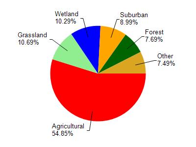
Mud Lake is located in the Yahara River and Lake Kegonsa watershed which is 126.33 mi². Land use in the watershed is primarily agricultural (54.90%), grassland (10.70%) and a mix of wetland (10.30%) and other uses (24.20%). This watershed has 145.73 stream miles, 3,600.04 lake acres and 6,832.19 wetland acres.
Nonpoint Source Characteristics
This watershed is ranked Medium for runoff impacts on streams, Low for runoff impacts on lakes and High for runoff impacts on groundwater and therefore has an overall rank of High. This value can be used in ranking the watershed or individual waterbodies for grant funding under state and county programs.However, all waters are affected by diffuse pollutant sources regardless of initial water quality. Applications for specific runoff projects under state or county grant programs may be pursued. For more information, go to surface water program grants.