Vernon
No
No
No
Fish and Aquatic Life
Overview
Sidie Hollow Lake is one of the few lakes in this watershed. Sidie Hollow Lake is 35 acres, with a maximum depth of 22 feet. This lake is located just south of Viroqua near the headwaters of the South Fork of the Bad Axe River and surrounded by Vernon County land known as Sidie Hollow Park. This lake was assessed for Fish and Aquatic Life uses in 2009 and considered "fair" based on satellite derived trophic state index data.
The lake is considered "eutrophic". Historical reports indicate that Sidie Hollow Lake is an impoundment constructed under the PL-566 conservation program. In the 1970's the water was clear, hard, alkaline, and considered to have moderate transparency. Today the lake is documented as "murky", although it drains to the South Fork of the Bad Axe River, a class III trout water. A 2003 fish survey of Sidie Hollow Lake documented largemouth bass, bluegill, brown trout, brook trout, yellow perch, black crappie and white sucker. Netting also documented both painted and snapping turtles.
Aquatic plant surveys were conducted on Sidie Hollow Lake in 1994 and again in 2005. From these surveys it was noted that the aquatic plant growth is distributed throughout Sidie Hollow Lake, over 66% of the lake, to a maximum rooting depth of 15 feet. The plant community is characterized by a fair diversity of plant species, and above average quality plant community for Wisconsin lakes, and a very high quality for the Driftless Region lakes. Filamentous algae increased in the lake since 1994 and the dominant plant species was coontail (Ceratophyllum demersum) in both 1994 and 2005.
An early spring snowmelt event took place on March 8-9, 2005 in south western Wisconsin. Manure spreading of farm fields was prevalent during this unusually early warm spell. Runoff of snowmelt with recently applied manure caused a major fish kill of Jersey Valley Lake, an impoundment in a neighboring watershed. This event prompted monitoring of Sidie Hollow Lake. The lake did have an area of depressed dissolved oxygen (3.1 mg/l) at the deepest point, but no fish kill.
Date 2010
Author Cynthia Koperski
Historical Description
Sidie Hollow Lake, T12N, R5W, Section 10 Surface Acres = 38.0, S.D.F. = 2.24, Maximum Depth = 22 feet.
This is another impoundment constructed under the PL-566 conservation program. The water is clear, hard, alkaline, ahd has moderate transparency. The impoundment is managed for brown trout, largemouth bass, and bluegill. The county maintains a park at the lake, and parking and a boat launch are available. Mallards and teal nest here, and migrating puddle and diving ducks use the water.
From: Klick, Thomas A. and Threinen, C.W. Lake and Stream Classification Project. Surface Water Resources of Vernon County. Wisconsin Department of Natural Resources, Madison, WI.
Date 1973
Author Surface Water Inventory Of Wisconsin
Recommendations
Shoreland Ordinance
Vernon County proposes to amend or create a shoreland zoning ordinance that complies with the requirements of NR 115, Wisconsin Administrative Code (as revised effective February 1, 2010) and retain existing regulations that exceed the water resource protections of NR 115 or are specific or unique to local needs.
Lakes Planning Grant
Coe Hollow Creek, Sidie Hollow Lake Grants
Engage Volunteers in Monitoring/Restoration
Coe Hollow Creek, Sidie Hollow
Management Goals
Wisconsin's Water Quality Standards provide qualitative and quantitative goals for waters that are protective of Fishable, Swimmable conditions [Learn more]. Waters that do not meet water quality standards are considered impaired and restoration actions are planned and carried out until the water is once again fishable and swimmable
Management goals can include creation or implementation of a Total Maximum Daily Load analysis, a Nine Key Element Plan, or other restoration work, education and outreach and more. If specific recommendations exist for this water, they will be displayed below online.
Monitoring
Monitoring the condition of a river, stream, or lake includes gathering physical, chemical, biological, and habitat data. Comprehensive studies often gather all these parameters in great detail, while lighter assessment events will involve sampling physical, chemical and biological data such as macroinvertebrates. Aquatic macroinvertebrates and fish communities integrate watershed or catchment condition, providing great insight into overall ecosystem health. Chemical and habitat parameters tell researchers more about human induced problems including contaminated runoff, point source dischargers, or habitat issues that foster or limit the potential of aquatic communities to thrive in a given area. Wisconsin's Water Monitoring Strategy was recenty updated.
Grants and Management Projects
Monitoring Projects
| WBIC | Official Waterbody Name | Station ID | Station Name | Earliest Fieldwork Date | Latest Fieldwork Date | View Station | View Data |
|---|
| 1641400 | Sidie Hollow Lake | 10037703 | Sidie Hollow Lake nearshore | 9/19/2012 | 9/19/2012 | Map | Data |
| 1641400 | Sidie Hollow Lake | 10037641 | Sidie Hollow Lake | 9/19/2012 | 6/13/2017 | Map | Data |
| 1641400 | Sidie Hollow Lake | 633131 | Sidie Hollow Lake - East End Site 6 | 8/13/1992 | 7/15/1993 | Map | Data |
| 1641400 | Sidie Hollow Lake | 10005954 | Sidie Hollow Lake | 8/18/1994 | 4/3/2019 | Map | Data |
| 1641400 | Sidie Hollow Lake | 633129 | Sidie Hollow Lake - Deep Hole | 3/4/1973 | 7/1/2022 | Map | Data |
| 1641400 | Sidie Hollow Lake | 10017561 | Sidie Hollow Lake -- Access | 8/11/2011 | 8/11/2011 | Map | Data |
|
Watershed Characteristics
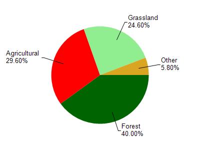
Sidie Hollow Lake is located in the Bad Axe River watershed which is 195.49 mi². Land use in the watershed is primarily forest (40%), agricultural (29.60%) and a mix of grassland (24.60%) and other uses (5.80%). This watershed has 468.27 stream miles, 489.81 lake acres and 2,552.28 wetland acres.
Nonpoint Source Characteristics
This watershed is ranked High for runoff impacts on streams, Not Ranked for runoff impacts on lakes and Low for runoff impacts on groundwater and therefore has an overall rank of Low. This value can be used in ranking the watershed or individual waterbodies for grant funding under state and county programs.However, all waters are affected by diffuse pollutant sources regardless of initial water quality. Applications for specific runoff projects under state or county grant programs may be pursued. For more information, go to surface water program grants.