")
2.75 Miles
0.92 - 3.67
Cool-Cold Headwater, Coldwater
2021
Good
Vernon
Yes
No
No
Fish and Aquatic Life
Overview
Coe Hollow Creek, located in central Vernon County, flows for approximately one mile in a southwesterly direction before reaching Sidie Hollow Lake just west of Viroqua. It has a moderately high gradient of 85 feet per mile and drains steep forested hills and some agricultural land. Coe Hollow Creek is a Class I trout stream for its entire length of 1.2 miles.
The most recent survey, conducted in 1999, documented cool clear water with a stream bottom comprised mainly of gravel and rubble with lesser amounts of silt and sand. Most of the riparian area was woodland, with some manicured lawn in the county park. In-stream habitat consisted of LUNKER structures, undercut banks and woody debris. Naturally reproducing populations of both brook and brown were documented as well as a wide variety of aquatic invertebrates. Only one forage fish species was observed. The WDNR stocking records show this stream has never been stocked. Access is possible from one road crossing, Sidie Hollow Lake and Sidie Hollow County Park.
Date 2002
Author Aquatic Biologist
Condition
Wisconsin has over 84,000 miles of streams, 15,000 lakes and milllions of acres of wetlands. Assessing the condition of this vast amount of water is challenging. The state's water monitoring program uses a media-based, cross-program approach to analyze water condition. An updated monitoring strategy (2015-2020) is now available. Compliance with Clean Water Act fishable, swimmable standards are located in the Executive Summary of Water Condition in 2018. See also the 'monitoring and projects' tab.
Reports
Recommendations
Shoreland Ordinance
Vernon County proposes to amend or create a shoreland zoning ordinance that complies with the requirements of NR 115, Wisconsin Administrative Code (as revised effective February 1, 2010) and retain existing regulations that exceed the water resource protections of NR 115 or are specific or unique to local needs.
Lakes Planning Grant
Coe Hollow Creek, Sidie Hollow Lake Grants
Engage Volunteers in Monitoring/Restoration
Coe Hollow Creek, Sidie Hollow
Management Goals
Wisconsin's Water Quality Standards provide qualitative and quantitative goals for waters that are protective of Fishable, Swimmable conditions [Learn more]. Waters that do not meet water quality standards are considered impaired and restoration actions are planned and carried out until the water is once again fishable and swimmable
Management goals can include creation or implementation of a Total Maximum Daily Load analysis, a Nine Key Element Plan, or other restoration work, education and outreach and more. If specific recommendations exist for this water, they will be displayed below online.
Monitoring
Monitoring the condition of a river, stream, or lake includes gathering physical, chemical, biological, and habitat data. Comprehensive studies often gather all these parameters in great detail, while lighter assessment events will involve sampling physical, chemical and biological data such as macroinvertebrates. Aquatic macroinvertebrates and fish communities integrate watershed or catchment condition, providing great insight into overall ecosystem health. Chemical and habitat parameters tell researchers more about human induced problems including contaminated runoff, point source dischargers, or habitat issues that foster or limit the potential of aquatic communities to thrive in a given area. Wisconsin's Water Monitoring Strategy was recenty updated.
Grants and Management Projects
Monitoring Projects
| WBIC | Official Waterbody Name | Station ID | Station Name | Earliest Fieldwork Date | Latest Fieldwork Date | View Station | View Data |
|---|
| 1641200 | Coe Hollow Creek | 10044153 | Coe Hollow Creek - Hwy XX | 7/13/2015 | 10/20/2021 | Map | Data |
| 1641200 | Coe Hollow Creek | 10008992 | Coe Hollow - Mouth Stream | | | Map | Data |
| 1641200 | Coe Hollow Creek | 633128 | North Inlet - North Inlet | 3/4/1973 | 10/7/1974 | Map | Data |
| 1641200 | Coe Hollow Creek | 10013533 | Coe Hollow Station 1-300 Feet Upstream From Mouth (Cth Xx) | 1/1/2015 | 1/1/2015 | Map | Data |
| 1641200 | Coe Hollow Creek | 10008993 | Coe Hollow Station 2 - 600 Feet Down Bridge Xx | | | Map | Data |
| 1641200 | Coe Hollow Creek | 10007761 | Coe Hollow Creek east of Hwy XX | 2/8/2006 | 5/27/2019 | Map | Data |
|
Watershed Characteristics
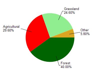
Coe Hollow Creek is located in the Bad Axe River watershed which is 195.49 mi². Land use in the watershed is primarily forest (40%), agricultural (29.60%) and a mix of grassland (24.60%) and other uses (5.80%). This watershed has 468.27 stream miles, 489.81 lake acres and 2,552.28 wetland acres.
Nonpoint Source Characteristics
This watershed is ranked High for runoff impacts on streams, Not Ranked for runoff impacts on lakes and Low for runoff impacts on groundwater and therefore has an overall rank of Low. This value can be used in ranking the watershed or individual waterbodies for grant funding under state and county programs.However, all waters are affected by diffuse pollutant sources regardless of initial water quality. Applications for specific runoff projects under state or county grant programs may be pursued. For more information, go to surface water program grants.
Coe Hollow Creek is considered a Cool-Cold Headwater, Coldwater under the state's Natural Community Determinations.
Natural communities (stream and lake natural communities) represent model results and DNR staff valiation processes that confirm or update predicted conditions based on flow and temperature modeling from historic and current landscape features and related variables. Predicated flow and temperatures for waters are associated predicated fish assemblages (communities). Biologists evaluate the model results against current survey data to determine if the modeled results are corect and whether biological indicators show water quaity degradation. This analysis is a core component of the state's resource management framework. Wisconsin's Riverine Natural Communities.
Cool (Cold-Transition) Headwaters are small, usually perennial streams with cold to cool summer temperatures. Coldwater fishes are common to uncommon (<10 per 100 m), transitional fishes are abundant to common, and warm water fishes are uncommon to absent. Headwater species are abundant to common, mainstem species are common to absent, and river species are absent.
More Interactive Maps
Maps of Watershed