Iron
No
Yes
No
Fish and Aquatic Life
Overview
The Gile Flowage on the West Fork Montreal River is a headwater storage reservoir essential to the operation of the two hydropower projects downstream on the Montreal River. Norther States Power draws and refills the Gile Flowage to provide seasonally uniform streamflow for maximum generation at its Superior Falls and Saxon Falls hydro projects. The flowage is gradually lowered in winter in anticipation of collecting and storing spring runoff. That stored water is then gradually released to maintain flows during summer. Between 1974 and 1993 the maximum winter drawdown depth at the flowage ranged between 5.7 and 15.6 feet, averaging 9.9. It is possible such winter drawdown can affect the fish community in the impoundment by decreasing the winter survival of walleye fingerlings. WDNR fisheries staff have at least a decade of walleye density data for fingerling and yearlings, along with concurrent winter water levels. While fingerling densities showed the natural variation expected, yearling densities were low in all years. Fisheries managers suspect the drawdown may affect survival over their first winter by reducing the available shoreline habitat in the impoundment. An eight-foot drawdown reduces the surface area of the impoundment by about 46 percent and the volume by 58 percent.
WDNR asked the Federal Energy Regulatory Commission (FERC) to analyze the effects of winter drawdowns as part of the cumulative impacts analysis for the Superior Falls Hydro licensing decision. FERC denied the request, citing that it had no authority at the Gile Flowage. FERC subsequently initiated an investigation of its jurisdiction at the Gile Flowage, but has yet to make a decision on its authority. WDNR suggested a moderation of the drawdown over a three-year test period to see if there is any change in walleye fingerling survival. If no evidence came from the study showing that modified drawdown altered walleye survivability, the traditional operating procedures could resume. Northern States Power declined to participate in the study, citing economic concerns, regulatory uncertainties and increased liabilities as a result of flooding, and has suggested the fingerling survival might be related to other factors such as entrainment in the works of the dam.
From: Turville-Heitz, Meg. 1999. Lake Superior Basin Water Quality Management Plan. Wisconsin Department of Natural Resources, Madison, WI.
Date 1999
Author Aquatic Biologist
Recommendations
Management Goals
Wisconsin's Water Quality Standards provide qualitative and quantitative goals for waters that are protective of Fishable, Swimmable conditions [Learn more]. Waters that do not meet water quality standards are considered impaired and restoration actions are planned and carried out until the water is once again fishable and swimmable
Management goals can include creation or implementation of a Total Maximum Daily Load analysis, a Nine Key Element Plan, or other restoration work, education and outreach and more. If specific recommendations exist for this water, they will be displayed below online.
Monitoring
Monitoring the condition of a river, stream, or lake includes gathering physical, chemical, biological, and habitat data. Comprehensive studies often gather all these parameters in great detail, while lighter assessment events will involve sampling physical, chemical and biological data such as macroinvertebrates. Aquatic macroinvertebrates and fish communities integrate watershed or catchment condition, providing great insight into overall ecosystem health. Chemical and habitat parameters tell researchers more about human induced problems including contaminated runoff, point source dischargers, or habitat issues that foster or limit the potential of aquatic communities to thrive in a given area. Wisconsin's Water Monitoring Strategy was recenty updated.
Grants and Management Projects
Monitoring Projects
| WBIC | Official Waterbody Name | Station ID | Station Name | Earliest Fieldwork Date | Latest Fieldwork Date | View Station | View Data |
|---|
| 2942300 | Gile Flowage | 10019467 | Gile Flowage - Access off Park Road | 9/18/2004 | 7/9/2026 | Map | Data |
| 2942300 | Gile Flowage | 263041 | Gile Flowage - 3/4 Mile Above Dam | 6/21/1994 | 8/9/2000 | Map | Data |
| 2942300 | Gile Flowage | 264023 | Gile Flowage - Gile Flowage | 8/1/2023 | 8/1/2023 | Map | Data |
| 2942300 | Gile Flowage | 10020042 | Gile Flowage - Access off Spring Camp Road | 6/22/2005 | 6/23/2022 | Map | Data |
| 2942300 | Gile Flowage | 10019751 | Gile Flowage -- 4-H Landing | 7/27/2008 | 8/30/2009 | Map | Data |
| 2942300 | Gile Flowage | 263124 | Gile Flowage - Deep Hole | 10/23/1993 | 7/14/2026 | Map | Data |
| 4000009 | Fifield Creek | 10036282 | Fifield Creek - Area of Open Water | | | Map | Data |
| 5002532 | Unnamed | 10049234 | Unnamed (5002532) trib to Gile Flowage 8m US Spring Camp Rd | 10/23/2017 | 10/23/2017 | Map | Data |
| 2942300 | Gile Flowage | 263038 | Gile Flowage - Near Dam | 5/10/1994 | 6/24/1994 | Map | Data |
| 2942300 | Gile Flowage | 263123 | Montreal River | | | Map | Data |
| 2942300 | Gile Flowage | 263039 | Gile Flowage - Far Dam | 5/10/1994 | 5/10/1994 | Map | Data |
|
Watershed Characteristics
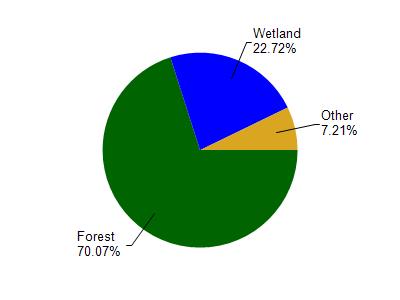
Gile Flowage is located in the Montreal River watershed which is 226.26 mi². Land use in the watershed is primarily forest (70%), wetland (22.70%) and a mix of open (3.10%) and other uses (4.10%). This watershed has 382.88 stream miles, 1,369.22 lake acres and 30,742.44 wetland acres.
Nonpoint Source Characteristics
This watershed is ranked Not Ranked for runoff impacts on streams, Not Available for runoff impacts on lakes and Low for runoff impacts on groundwater and therefore has an overall rank of Low. This value can be used in ranking the watershed or individual waterbodies for grant funding under state and county programs.However, all waters are affected by diffuse pollutant sources regardless of initial water quality. Applications for specific runoff projects under state or county grant programs may be pursued. For more information, go to surface water program grants.