Vernon
Yes
No
No
Fish and Aquatic Life
Overview
Springville Branch, located in west central Vernon County, flows for approximately eight miles in a westerly direction before reaching the North Fork of the Bad Axe River. It has a moderate gradient of 40 feet per mile and drains steep forests, lowland pasture, agricultural land and a portion of the City of Viroqua. The natural origin of Springville Branch is in the small village of Springville where springs well up in the stream bed creating a quicksand like stream bottom. However, since the City of Viroqua discharges stormwater and treated wastewater to a natural channel that eventually reaches the Springville Branch at Springville, the length of the perennial flowing stream has increased. The downstream end of Springville Branch flows through Duck Egg, a Vernon County park, where a wet flood control structure is owned and maintained by Vernon County.
Springville Branch contains cool, clear water which turns turbid during periods of rain and associated run-off. Fish kills have sporadically occurred during high flow events throughout the years. The ultimate source of these fish kills has not been positively identified. Springville Branch is a Class II trout stream from its mouth upstream to Springville (approximately 7.6 miles), and a limited aquatic life stream upstream of Springville to Viroqua. Limited aquatic life streams cannot provide the life cycle requirements for fish species, and have limited ability to support other fully aquatic life forms.
The latest fish and habitat surveys, completed in 1998 and 1999 documented a stream bottom composed mainly of gravel and rubble with lesser amounts of silt and sand. The presence of beaver dams caused silt accumulation and altered flow of the stream. The streambanks contained little to no erosion. A wide variety of aquatic vegetation and aquatic insects, as well as pickerel frogs and wood turtles were documented during these surveys. Fish collected include brook and brown trout, smallmouth bass, green sunfish and a variety of forage fish species. Maintenance or improvement of Springville Branch includes control of beaver dams, reduction of non-point source runoff, and proper operation of the Viroqua Wastewater Treatment Plant. WDNR stocked Springville Branch from 1960 to 1998 with brown trout and occasionally with rainbow trout and smallmouth bass. Four road crossings and Duck Egg County Park provide access to the stream.
Date 2002
Author Aquatic Biologist
Historical Description
Bad Axe River, Springville Branch, T13N, R5W, Section 19. Surface Acres = 13.8, Miles = 7.6, Gradient-=40.0 feet per mile.
This clear, hard water stream flows in a general westerly direction and is a tributary of the North Fork Bad Axe River. The entire stream is Class III brown trout water, and that portion from Springville downstream is also considered smallrrouth bass water. Carp and forage fish species are also present. The winter aerial groundwater survey found open water in the lower half of the stream and scattered open areas elsewhere. Gravel is somewhat more prevalent than sand and rubble. Other bottom types include some silt and small amounts of boulder and detritus. Four road crossings provide access. Beaver are present. Teal and wood ducks nest along the stream, and migrant puddle ducks use the water. Pollution in the form of domestic sewage has been known to enter the stream from the Viroqua municipal sewage treatment plant, and washwater from the Cooperative Creamery at Viroqua has also been observed entering the stream above the sewage treatment plant. These two pollution sources appear to comprise the total initial flow of the Springville Branch.
From: Klick, Thomas A. and Threinen, C.W., 1973. Lake and Stream Classification Project. Surface Water Resources of Vernon County, Department of Natural Resources, Madison, WI.
Date 1973
Author Surface Water Inventory Of Wisconsin
Condition
Wisconsin has over 84,000 miles of streams, 15,000 lakes and milllions of acres of wetlands. Assessing the condition of this vast amount of water is challenging. The state's water monitoring program uses a media-based, cross-program approach to analyze water condition. An updated monitoring strategy (2015-2020) is now available. Compliance with Clean Water Act fishable, swimmable standards are located in the Executive Summary of Water Condition in 2018. See also the 'monitoring and projects' tab.
Reports
Recommendations
Control Streambank Erosion
The Springville Br Bad Axe River fishery would benefit from the reduction of stream bank erosion
Management Goals
Wisconsin's Water Quality Standards provide qualitative and quantitative goals for waters that are protective of Fishable, Swimmable conditions [Learn more]. Waters that do not meet water quality standards are considered impaired and restoration actions are planned and carried out until the water is once again fishable and swimmable
Management goals can include creation or implementation of a Total Maximum Daily Load analysis, a Nine Key Element Plan, or other restoration work, education and outreach and more. If specific recommendations exist for this water, they will be displayed below online.
Monitoring
Monitoring the condition of a river, stream, or lake includes gathering physical, chemical, biological, and habitat data. Comprehensive studies often gather all these parameters in great detail, while lighter assessment events will involve sampling physical, chemical and biological data such as macroinvertebrates. Aquatic macroinvertebrates and fish communities integrate watershed or catchment condition, providing great insight into overall ecosystem health. Chemical and habitat parameters tell researchers more about human induced problems including contaminated runoff, point source dischargers, or habitat issues that foster or limit the potential of aquatic communities to thrive in a given area. Wisconsin's Water Monitoring Strategy was recenty updated.
Grants and Management Projects
Monitoring Projects
| WBIC | Official Waterbody Name | Station ID | Station Name | Earliest Fieldwork Date | Latest Fieldwork Date | View Station | View Data |
|---|
| 1642200 | Springville Br Bad Axe River | 10029205 | Springville Branch - near Olson Lane | 11/18/2004 | 11/18/2004 | Map | Data |
| 1642200 | Springville Br Bad Axe River | 10008980 | Springville Branch Station #2 Vikemyr Rd. | 3/30/1994 | 1/1/2015 | Map | Data |
| 1642200 | Springville Br Bad Axe River | 10011666 | Springville Br Bad Axe River - Springville Branch Bad Axe River Remap 0336 | | | Map | Data |
| 1642200 | Springville Br Bad Axe River | 10013786 | Springville Branch Bad Axe Station 1 - Downstream 900 Ft. Of Irish Rd. Bridge Crossing | 10/17/1978 | 10/17/1978 | Map | Data |
| 1642200 | Springville Br Bad Axe River | 10015316 | Springville Br Bad Axe River Station 2 - Approx 1460m Upstream From Irish Ridge Rd. | 1/1/2015 | 1/1/2015 | Map | Data |
| 1642200 | Springville Br Bad Axe River | 10008982 | Springville Branch Station #3 76' U/S From Bridge On Cth B | 10/17/1978 | 8/12/2009 | Map | Data |
| 1642200 | Springville Br Bad Axe River | 10015573 | Springville Branch St. 2 - Stepping Stone Crossing | | | Map | Data |
| 1642200 | Springville Br Bad Axe River | 10031099 | Spring to Springville Br. upstream CTH B | 3/31/2010 | 3/31/2010 | Map | Data |
| 1642200 | Springville Br Bad Axe River | 633030 | Springville Creek - Above Springville | 2/23/1982 | 10/20/2021 | Map | Data |
| 1642200 | Springville Br Bad Axe River | 633032 | Springville Creek Trib at Sth 14 | 1/7/1982 | 7/31/1983 | Map | Data |
| 1642200 | Springville Br Bad Axe River | 10029592 | Springville Branch St. 3 - 2008 | 1/1/2015 | 1/1/2015 | Map | Data |
| 1642200 | Springville Br Bad Axe River | 10015924 | Springville Branch - Sampled 30 Feet Riffle Starting 70 Feet Below The Farm Road Culvert 1.25 Mi Abovehwy B Crossing Ms2 | 5/2/1978 | 11/14/1991 | Map | Data |
| 1642200 | Springville Br Bad Axe River | 633194 | Bad Axe River Springville Branch - Springville Branch Bad Axe River 0336-X | | | Map | Data |
| 1642200 | Springville Br Bad Axe River | 10014654 | Springville Branch Bad Axe River At Lee Driveway | 10/17/1978 | 8/14/2002 | Map | Data |
| 1642200 | Springville Br Bad Axe River | 10015966 | Springville Branch - 30 Feet Above Hwy B Bridge 80 Feet Aboveconfluence With Dry Trib From North Ms3 | 11/14/1991 | 11/14/1991 | Map | Data |
| 1642200 | Springville Br Bad Axe River | 10015925 | Springville Branch - Sampled 30 Feet Riffle Starting 70 Feet Below The Farm Road Culvert 1.25 Mi Abovehwy B Crossing Ms2 | 11/14/1991 | 11/14/1991 | Map | Data |
| 1642200 | Springville Br Bad Axe River | 10043241 | Springville Br of Bad Axe River 1400' below PL structure | 1/1/2015 | 1/1/2015 | Map | Data |
| 1642200 | Springville Br Bad Axe River | 633029 | Springville Creek - Bl Viroqua Stp | 4/5/1983 | 4/5/1983 | Map | Data |
| 1642200 | Springville Br Bad Axe River | 10033428 | Springville Branch of the Bad Axe River - spring at old cistern site | | | Map | Data |
| 1642200 | Springville Br Bad Axe River | 10015965 | Springville Branch - 30 Feet Above Hwy B Bridge 80 Feet Aboveconfluence With Dry Trib From North Ms3 | 11/14/1991 | 11/14/1991 | Map | Data |
| 1642200 | Springville Br Bad Axe River | 10016276 | Springville Branch - First Riffle Above Pool/Bend Ofhabitat And Fish Station #1 | 10/6/1999 | 10/6/1999 | Map | Data |
| 1642200 | Springville Br Bad Axe River | 10037668 | Springville Branch Bad Axe River at first driveway crossing US along Miller Road | 7/25/2013 | 1/1/2015 | Map | Data |
| 1642200 | Springville Br Bad Axe River | 10008977 | Springville Branch Station #1 826' D/S From Fence | 8/19/2008 | 8/12/2009 | Map | Data |
| 1642200 | Springville Br Bad Axe River | 10013787 | Springville Branch Bad Axe Station 2 - Iron Grate Outlet Of Water Contol Structure | | | Map | Data |
| 1642200 | Springville Br Bad Axe River | 10015315 | Springville Branch Bad Axe River - 1st Crossing Approx. 190m Up From Irish Ridge Rd. | | | Map | Data |
| 1642200 | Springville Br Bad Axe River | 10015317 | Springville Branch Bad Axe River Station 3 - Bridge On Vikemyr Rd. | 8/19/2008 | 9/16/2008 | Map | Data |
| 1642200 | Springville Br Bad Axe River | 10015572 | Springville Branch St. 1 - Road Crossing Above Walking Bridge | 5/14/1979 | 1/1/2015 | Map | Data |
| 1642200 | Springville Br Bad Axe River | 633042 | Springville Br Creek - Tn Rd Sec 19 | | | Map | Data |
| 1642200 | Springville Br Bad Axe River | 633013 | Springville Br Bad Axe River - Vernon County Home Stp Viroqua | 8/25/1976 | 10/18/1978 | Map | Data |
| 1642200 | Springville Br Bad Axe River | 633193 | Bad Axe River Springville Branch - 0336-B at Irish Ridge Rd | 4/17/1987 | 3/30/1994 | Map | Data |
| 1642200 | Springville Br Bad Axe River | 633031 | Springville Branch Bad Axe River - Springville Cr Bl Springville | 5/2/1978 | 9/16/1999 | Map | Data |
|
Watershed Characteristics
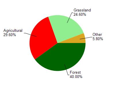
Springville Br Bad Axe River is located in the Bad Axe River watershed which is 195.49 mi². Land use in the watershed is primarily forest (40%), agricultural (29.60%) and a mix of grassland (24.60%) and other uses (5.80%). This watershed has 468.27 stream miles, 489.81 lake acres and 2,552.28 wetland acres.
Nonpoint Source Characteristics
This watershed is ranked High for runoff impacts on streams, Not Ranked for runoff impacts on lakes and Low for runoff impacts on groundwater and therefore has an overall rank of Low. This value can be used in ranking the watershed or individual waterbodies for grant funding under state and county programs.However, all waters are affected by diffuse pollutant sources regardless of initial water quality. Applications for specific runoff projects under state or county grant programs may be pursued. For more information, go to surface water program grants.