Waupaca
No
No
No
Fish and Aquatic Life
Overview
Pigeon Lake, in the Pigeon River Watershed, is a 173.01 acre lake that falls in Waupaca County. This lake is managed for fishing and swimming and is currently not considered impaired.
Date 2011
Author Aquatic Biologist
Historical Description
Source: 1971, Surface Water Resources of Waupaca County Pigeon (Clintonville) Lake, T25N, R14E, Sections 22, 23 Surface Acres = 217.7, S.D.F. = 3.14, Maximum Depth = 12 feet.
Pigeon Lake is a hard water impoundment of the Pigeon River located in the City of Clintonville. This water is light brown in color and highly productive. Water levels are maintained by a seven-foot dam. In addition to the Pigeon River two smaller streams enter the pond. Muck is the predominant littoral bottom material. Northern pike, largemouth bass, bluegill, black crappie, rock bass, pumpkinseed, bullhead, and white sucker are present. Occasionally the pond suffers from a partial winterkill but this does not cause any major management problems. There are no records on waterfowl or aquatic furbearer use available. Hunting is allowed outside of the city limits. Access is provided by three improved public boat landings, one public access without a landing, and by navigable water via the Pigeon River. Pickerel Point Memorial Park provides picnic facilities and two of the improved boat landings. This park is owned by the local school district.
Date 1971
Author Surface Water Inventory Of Wisconsin
Condition
Wisconsin has over 84,000 miles of streams, 15,000 lakes and milllions of acres of wetlands. Assessing the condition of this vast amount of water is challenging. The state's water monitoring program uses a media-based, cross-program approach to analyze water condition. An updated monitoring strategy (2015-2020) is now available. Compliance with Clean Water Act fishable, swimmable standards are located in the Executive Summary of Water Condition in 2018. See also the 'monitoring and projects' tab.
Reports
Recommendations
Lake Management Plan Development
The Pigeon Lake Protection & Rehabilitation District proposes three demonstration projects to restore approximately 800 feet of shoreline within the City of Clintonville (Pickerel Park), restore approximately 100 feet of streambank along the Pigeon River, and purchase conservation easements in perpetuity along approximately two miles of agricultural land adjacent to Brandy Creek.
Management Goals
Wisconsin's Water Quality Standards provide qualitative and quantitative goals for waters that are protective of Fishable, Swimmable conditions [Learn more]. Waters that do not meet water quality standards are considered impaired and restoration actions are planned and carried out until the water is once again fishable and swimmable
Management goals can include creation or implementation of a Total Maximum Daily Load analysis, a Nine Key Element Plan, or other restoration work, education and outreach and more. If specific recommendations exist for this water, they will be displayed below online.
Monitoring
Monitoring the condition of a river, stream, or lake includes gathering physical, chemical, biological, and habitat data. Comprehensive studies often gather all these parameters in great detail, while lighter assessment events will involve sampling physical, chemical and biological data such as macroinvertebrates. Aquatic macroinvertebrates and fish communities integrate watershed or catchment condition, providing great insight into overall ecosystem health. Chemical and habitat parameters tell researchers more about human induced problems including contaminated runoff, point source dischargers, or habitat issues that foster or limit the potential of aquatic communities to thrive in a given area. Wisconsin's Water Monitoring Strategy was recenty updated.
Grants and Management Projects
Monitoring Projects
| WBIC | Official Waterbody Name | Station ID | Station Name | Earliest Fieldwork Date | Latest Fieldwork Date | View Station | View Data |
|---|
| 293300 | Pigeon Lake | 693176 | Pigeon Lake - Site B | 7/3/1990 | 6/30/2026 | Map | Data |
| 293300 | Pigeon Lake | 10007374 | Pigeon Lake | 6/1/1993 | 9/30/2017 | Map | Data |
| 293300 | Pigeon Lake | 10043366 | Pfeiffer (Grady) Lake Outlet to Pigeon Lake at Lakeshore Road | 5/19/2015 | 10/30/2015 | Map | Data |
| 293300 | Pigeon Lake | 693049 | Pigeon Lake - Deep Spot | | | Map | Data |
| 293300 | Pigeon Lake | 693175 | Pigeon Lake - Site A | 7/3/1990 | 9/26/2001 | Map | Data |
| 293300 | Pigeon Lake | 10019681 | Pigeon River -- Access | | | Map | Data |
| 293300 | Pigeon Lake | 10019080 | Pigeon Lake -- Access | 7/7/2013 | 8/17/2013 | Map | Data |
|
Watershed Characteristics
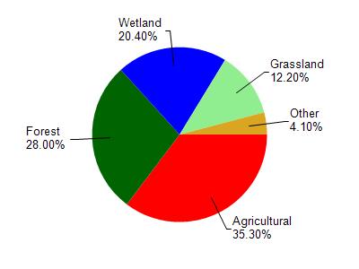
Pigeon Lake is located in the Pigeon River watershed which is 116.32 mi². Land use in the watershed is primarily agricultural (35.30%), forest (28%) and a mix of wetland (20.40%) and other uses (16.30%). This watershed has 146.47 stream miles, 197.04 lake acres and 15,030.25 wetland acres.
Nonpoint Source Characteristics
This watershed is ranked Medium for runoff impacts on streams, High for runoff impacts on lakes and Low for runoff impacts on groundwater and therefore has an overall rank of Low. This value can be used in ranking the watershed or individual waterbodies for grant funding under state and county programs.This water is ranked High Lake for individual Impoundments based on runoff problems and the likelihood of success from project implementation.