Vernon
Yes
No
No
Fish and Aquatic Life
Overview
From Sebranek Lane to the headwaters (class 3).
Date 2002
Author Aquatic Biologist
Overview
The West Branch of the Baraboo River, located in northeastern Vernon County and western
Juneau County, flows in a northeasterly direction for 16 miles before reaching the Baraboo
River at Union Center. One dam at the Village of Hillsboro impounds the West Branch of the
Baraboo River at its midpoint. Some people and references in documents erroneously identify
the portion of river downstream of Hillsboro Lake as South Branch of the Baraboo River
when in fact it is the West Branch of the Baraboo River. The South Branch of the Baraboo
River, also known as South Branch Creek, is a tributary to the West Branch at Hillsboro Lake.
The West Branch of the Baraboo River has a gradient of 69 feet per mile upstream of
Hillsboro Lake and drains hilly agricultural and forested land. The West Branch of the
Baraboo River upstream of Hillsboro Lake is in the Hillsboro Lake Priority Watershed.
The West Branch of the Baraboo River is a Class III trout stream for 4.6 miles upstream of
Sebranek Road just west of Hillsboro. The remainder of the river contains forage fish species
and possibly some game fish species.
The most recent biological survey, conducted in 1988, documented a marginal trout fishery
upstream of Sebranek Road just west of Hillsboro. The stretch of river from this bridge downstream
to Hillsboro Lake was inhabited by white suckers and largemouth bass. The West
Branch of the Baraboo River upstream of Hillsboro Lake suffers from flooding, sedimentation
of pools and riffles, manure runoff, and lack of instream habitat for adult trout. The water
quality standard for dissolved oxygen has been violated under low-flow conditions
downstream of Hillsboro Lake in 1983, consequently a 1.75 mile section of this river below
the lake is classified as an impaired water (303d list). Several factors may contribute to the
lack of dissolved oxygen including: discharges from the Hillsboro wastewater treatment plant
and from Foremost Farms USA, low stream velocity, an upstream impoundment with algae
problems, and stream channelization. To increase dissolved oxygen levels in the river, the
Village of Hillsboro may want to review and possibly change dam operation procedures
during summer months when algae blooms occur. Since this stretch of river has a very low
gradient which is not conducive to aeration, an alteration of the river to induce more aeration
may also prove beneficial. If dissolved oxygen levels in the West Branch of the Baraboo
River consistently stay above the state standard, removal from the impaired waters list would
result. WDNR records indicate that the West Branch of the Baraboo River has been stocked
with brown trout consistently since 1960. Access to the West Branch of the Baraboo River is
from seven road crossings.
Ripp, Coreen, Koperski, Cindy and Folstad, Jason. 2002. The State of the Lower Wisconsin River Basin.
PUBL WT-559-2002. Wisconsin Department of Natural Resources, Madison, WI.
Date 2002
Author Cynthia Koperski
Historical Description
This stream is a Class III trout stream above Hillsboro Lake. Water quality is generally
good in the upper reaches, with water temperatures and dissolved oxygen levels suitable
for trout. Nonpoint sources of pollution are affecting habitat and water quality. The main
problems are with in-stream siltation filling spawning areas and deep pools, nutrient
loading to the stream, and elevated water temperatures in the lower reach (Biebl,1991).
The water quality standard for dissolved oxygen has been violated under lowflow
conditions (less than 7 cubic feet per second) downstrem of Hillsboro. Several
Factors may contribute to this problem, including the discharges from the Hillsboro
wastewater treatment plan and AMPI-Warner Creek Cheese, low stream velocity, an
upstream impoundmnt, stream channelization, and beaver ponds (Sorge, 1991-92).
Date 1994
Author Surface Water Inventory Of Wisconsin
Historical Description
Highway 80 to the headwaters (class 3).
Date 1980
Author Surface Water Inventory Of Wisconsin
Historical Description
Baraboo River, West Branch, T14N, R1E, Section 35. Surface Acres = 7.7, Miles = 5.8, Gradient: 69.2 feet per mile.
This clear, hard water stream flows in a general southeasterly direction and joins the South Branch in Field-Veterans Memorial Lake at Hi11sboro. The entire stream above the lake is Class III brown trout water. White suckers, creek chubs, and common shiners also inhabit the stream. Silt is the dominant bottom type, with sand, gravel, rubble, detritus. boulder. and clay also present. Access is possible from the impoundment at Hillsboro and from six road crossings. Approximately eight acres of wetland adjoin the stream. Wood ducks nest along the stream, and a small number of migrant puddle ducks use the water.
From: Klick, Thomas A. and Threinen, C.W. 1973. Lake and Stream Classification Project. Surface Water Resources of Vernon County, Department of Natural Resources, Madison, WI.
Date 1973
Author Surface Water Inventory Of Wisconsin
General Condition
West Branch Baraboo River (miles 9.3-15.79) was assessed during the 2018 listing cycle; new biological (macroinvertebrate and fish Index of Biotic Integrity (IBI) scores) and temperature sample data were clearly below the 2018 WisCALM listing thresholds for the Fish and Aquatic Life use. This water was meeting this designated use and was not considered impaired.
Date 2017
Author Ashley Beranek
Impaired Waters
The West Branch of the Baraboo River (Mouth to trib 1/2 mile west of Juneau-Vernon county line) was listed for phosphorus, sediment, and oxygen in 1998. Every two years between 2014 and 2018 phosphorus evaluation showed continued impairment. In 2020 bug community health indicated a possible impact on health. Further monitoring of bug community health is recommended. This water is part of the Wisconsin River TMDL.
Date 2019
Author Ashley Beranek
Condition
Wisconsin has over 84,000 miles of streams, 15,000 lakes and milllions of acres of wetlands. Assessing the condition of this vast amount of water is challenging. The state's water monitoring program uses a media-based, cross-program approach to analyze water condition. An updated monitoring strategy (2015-2020) is now available. Compliance with Clean Water Act fishable, swimmable standards are located in the Executive Summary of Water Condition in 2018. See also the 'monitoring and projects' tab.
Reports
Recommendations
County Land and Water Management Plan
The Vernon County Land Conservation Department proposes to reduce sedimentation to Hillsboro Lake by 1404 tons over a five year period through implementation of Best Management Practices approved, but unlikely to be funded at any time soon, by the state's Nonpoint Source Program. High Residue Management, Conservation Cropping Plans, Grassed Waterway, Critical Area Stabalization, Grade Stabalization Structures, Streambank Riprapping, Streambank Fencing, Stream Crossings and Streambank Shaping and Seeding.
Natural Community Review or Change
The West Branch of Baraboo River fish natural community designations of cool-cold were verified, and the fish and aquatic life should be changed to good or supporting.
Monitor Targeted Area
The West Branch of Baraboo River phosphorus monitoring site located at STH-33, should not be used as a stream site for calculation of phosphorus values, due to the site being located within Hillsboro Lake. Instead use the phosphorus values from the Sebranek Road site.
Delist Impaired Water
The West Branch should be removed from the impaired waters list for Low DO, phosphorus, sediment, total suspended solids and BOD. Biological information rated from fair to excellent and does not support listing the stream for biological impairment.
Delist Impaired Water
The West Branch of Baraboo River at Sebranek Road had a median value for phosphorus of 0.077 mg/l, but did not exceed the lower confidence limit for the 12 samples, thus is not considered as impaired for phosphorus. This water should not be listed as impaired.
Monitor Water Quality or Sediment
DNR should monitor Hillsboro Lake to determine lake health and condition.
Nine Key Element Plan
Hillsboro Priority PWS Plan - Nine Key Element Plan - The Hillsboro Priority Watershed Project plan assesses the nonpoint sources of pollution in the Hillsboro Watershed and guides the implementation of nonpoint source control measures.
Monitor Water Quality or Sediment
This assessment unit is 7 miles long and MIBI score reflects conditions at upper end of AU below mill pond outflow. Would prefer that bug and fish data be collected throughout this assessment unit before making a biological recommendation.
Protect Riparian or Shorelands
The West Branch of Baraboo River has some stream segments that, while not excessively grazed, have steep or vertical banks. DNR and Partners should implement stream bank erosion controls on bends to reduce erosion and stream siltation.
Restore Hydrology, Morphology
The West Branch of Baraboo River fish lunker structures in the segment upstream of STH-33 have either collapsed or silted in. DNR should work with Trout Unlimited to restore structures and improve cover for fish.
Partnership Project
DNR should work with the Hillsboro School District to encourage environmental programs and citizen monitoring of streams and Hillsboro Lake through the Citizen Lake Management Network and the Water Action Volunteer Programs.
Easement/Buffer
DNR should work on outreach efforts with landowners in the watershed, and research opportunities for harvestable buffers to provide economic incentives for maintaining buffers along streams.
Best Management Practices, Implement
DNR should investigate management actions that may help increase base flow and dissolved oxygen to the West Branch of the Baraboo River, downstream of the lake.
Management Goals
Wisconsin's Water Quality Standards provide qualitative and quantitative goals for waters that are protective of Fishable, Swimmable conditions [Learn more]. Waters that do not meet water quality standards are considered impaired and restoration actions are planned and carried out until the water is once again fishable and swimmable
Management goals can include creation or implementation of a Total Maximum Daily Load analysis, a Nine Key Element Plan, or other restoration work, education and outreach and more. If specific recommendations exist for this water, they will be displayed below online.
Monitoring
Monitoring the condition of a river, stream, or lake includes gathering physical, chemical, biological, and habitat data. Comprehensive studies often gather all these parameters in great detail, while lighter assessment events will involve sampling physical, chemical and biological data such as macroinvertebrates. Aquatic macroinvertebrates and fish communities integrate watershed or catchment condition, providing great insight into overall ecosystem health. Chemical and habitat parameters tell researchers more about human induced problems including contaminated runoff, point source dischargers, or habitat issues that foster or limit the potential of aquatic communities to thrive in a given area. Wisconsin's Water Monitoring Strategy was recenty updated.
Grants and Management Projects
Monitoring Projects
| WBIC | Official Waterbody Name | Station ID | Station Name | Earliest Fieldwork Date | Latest Fieldwork Date | View Station | View Data |
|---|
| 1288400 | West Branch Baraboo River | 633183 | West Branch Baraboo River at Sth 33 Near Hillsboro WI | 3/17/1994 | 10/18/2001 | Map | Data |
| 1288400 | West Branch Baraboo River | 10017181 | West Branch Baraboo at Sebranek Road | 1/31/2007 | 8/24/2015 | Map | Data |
| 1288400 | West Branch Baraboo River | 10032062 | W. Branch of Baraboo River 300 meters south of Grimm Rd. near Amberg Rd. | 11/12/2009 | 1/1/2015 | Map | Data |
| 1288400 | West Branch Baraboo River | 10011292 | West Branch Baraboo River Station #4 100m Downstream From Upper Culvert Richardson Property | 1/1/2015 | 1/1/2015 | Map | Data |
| 1288400 | West Branch Baraboo River | 10011291 | West Branch Baraboo River - West Branch Baraboo River Station #3 100m Upstream Bridge On Grimm Rd. | 1/1/2015 | 9/22/2015 | Map | Data |
| 1288400 | West Branch Baraboo River | 10011289 | West Branch Baraboo River - West Branch Baraboo River Station #1 Bridge On Sebranek Ln | | | Map | Data |
| 1291200 | Unnamed | 10032062 | W. Branch of Baraboo River 300 meters south of Grimm Rd. near Amberg Rd. | 11/12/2009 | 1/1/2015 | Map | Data |
| 1288400 | West Branch Baraboo River | 10039097 | West Branch Baraboo River 50 yds above HWY 33 bridge crossing | 1/1/2015 | 9/22/2015 | Map | Data |
| 1288400 | West Branch Baraboo River | 10011290 | West Branch Baraboo River - West Branch Baraboo River Station #2 Fenceline 20m Upstream Of Hwy 33 | 10/16/2001 | 10/16/2001 | Map | Data |
|
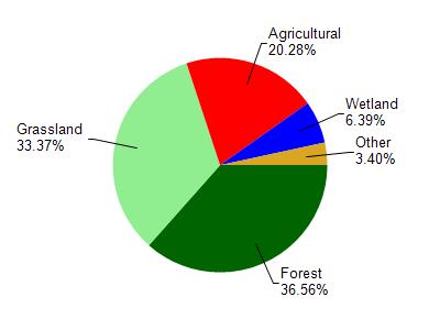
Watershed Characteristics
West Branch Baraboo River is located in the Seymour Creek and Upper Baraboo River watershed which is 171.73 mi². Land use in the watershed is primarily forest (36.60%), grassland (33.40%) and a mix of agricultural (20.30%) and other uses (9.80%). This watershed has 414.62 stream miles, 124.03 lake acres and 4,637.96 wetland acres.
Nonpoint Source Characteristics
This watershed is ranked Medium for runoff impacts on streams, Not Ranked for runoff impacts on lakes and High for runoff impacts on groundwater and therefore has an overall rank of High. This value can be used in ranking the watershed or individual waterbodies for grant funding under state and county programs.However, all waters are affected by diffuse pollutant sources regardless of initial water quality. Applications for specific runoff projects under state or county grant programs may be pursued. For more information, go to surface water program grants.