Portage
Yes
Yes
No
Fish and Aquatic Life
Overview
Tomorrow/Waupaca River Headwaters), in the Waupaca River Watershed, is a 30.90 mile river that falls in Portage County. This river is an outstanding/exceptional resource water under NR102 as well as a Class I Trout Water under the Fisheries Program. This river is managed for fishing and swimming and is currently considered impaired.
Date 2016
Author Ashley Beranek
Impaired Waters
Tomorrow/Waupaca River Headwaters from its headwaters to Nelsonville Pond (miles 18.45 to 32.3) was put on the impaired waters list for elevated temperature in the 2016 cycle. Evaluations of temperature and biology in 2018 and 2020 confirmed elevated temperature, but biology was in good condition.
Tomorrow/Waupaca River Headwaters from Nelsonville Pond to west of Hwy 66 (miles 32.3 to 34.1) was evaluated for temperature in 2018 and found to be in good condition. This segment is on the Healthy Waters List.
Date 2018
Author Ashley Beranek
Condition
Wisconsin has over 84,000 miles of streams, 15,000 lakes and milllions of acres of wetlands. Assessing the condition of this vast amount of water is challenging. The state's water monitoring program uses a media-based, cross-program approach to analyze water condition. An updated monitoring strategy (2015-2020) is now available. Compliance with Clean Water Act fishable, swimmable standards are located in the Executive Summary of Water Condition in 2018. See also the 'monitoring and projects' tab.
Reports
Recommendations
Monitor Water Quality or Sediment
The data from this proposed Local Needs project will be used in conjunction with the data from the related Directed Lakes project and will allow us to develop a comprehensive analysis of the recent Amherst Millpond transformation and ultimately enhance community awareness and participation in the watershed.
Monitor Water Quality or Sediment
This proposed Directed Lakes project will allow us to monitor the recent changes on the Amherst Millpond. We would like to conduct water sampling, PI aquatic plant survey, and an aquatic invasive species survey. In addition, we are also proposing a Local Needs project for the Amherst Millpond.
Data analysis, report production
Portage County Land and Water Conservation Department is sponsoring a project to expand capacity, enhance partnerships and develop a State of the Tomorrow River Report. Project final deliverables include: The State of the Tomorrow River Report is the primary deliverable in hard copy and electronic form. All data collected for the report, agendas and minutes from meetings with municipality boards and plan commissions and interested groups, newsletters, publications in newspapers, along with educational materials provided to the public and private schools will be shared with WDNR Water Resources staff. Specific project activities include: 1. Coordinate contributions to the State of the Tomorrow River Report by stewardship groups and technical partners in March 2017. 2. Create draft of the State of the Tomorrow River Report by October 2017. A report draft review gathering will be scheduled with all contributors for October 2017 and conducted following completion of the draft. The report will summarize current conditions, provide comparisons to earlier information, projections for future conditions and potential risks, and recommendations for protection and restoration. 3. Update, print and distribute State of the Tomorrow River Final Report by December 31st, 2017. Three hard copies will be sent to WDNR Water Resources staff along with the link to the electronic .pdf. 4. Provide list of stewardship groups, agencies, schools and municipalities receiving the report and copies of publications of the report in local newspapers to the WDNR Water Resources staff. 5. Provide dates, agendas, and minutes from meetings with municipality boards and plan commissions related to the State of the Tomorrow River Report to WDNR Water Resources staff. 6. Provide a description of how the report will be distributed to watershed property owners to WDNR Water Resources staff.
Monitor Water Quality or Sediment
Monitoring of phosphorus and nitrate concentrations in the streams of the Lower Little Wolf River should continue.
Nine Key Element Plan
Tomorrow/Waupaca River PWS Plan - Nine Key Element Plan - The Tomorrow/Waupaca River Priority Watershed Project plan assesses the nonpoint sources of pollution in the Tomorrow/Waupaca River Watershed and guides the implementation of nonpoint source control measures. These control measures are needed to meet specific water resource objectives for the Tomorrow/Waupaca Rivers and their tributaries. The purpose of this project is to reduce the amount of pollutants originating from nonpoint sources that reach surface water and groundwater within the Tomorrow/Waupaca River Priority Watershed Project area.
Management Goals
Wisconsin's Water Quality Standards provide qualitative and quantitative goals for waters that are protective of Fishable, Swimmable conditions [Learn more]. Waters that do not meet water quality standards are considered impaired and restoration actions are planned and carried out until the water is once again fishable and swimmable
Management goals can include creation or implementation of a Total Maximum Daily Load analysis, a Nine Key Element Plan, or other restoration work, education and outreach and more. If specific recommendations exist for this water, they will be displayed below online.
Monitoring
Monitoring the condition of a river, stream, or lake includes gathering physical, chemical, biological, and habitat data. Comprehensive studies often gather all these parameters in great detail, while lighter assessment events will involve sampling physical, chemical and biological data such as macroinvertebrates. Aquatic macroinvertebrates and fish communities integrate watershed or catchment condition, providing great insight into overall ecosystem health. Chemical and habitat parameters tell researchers more about human induced problems including contaminated runoff, point source dischargers, or habitat issues that foster or limit the potential of aquatic communities to thrive in a given area. Wisconsin's Water Monitoring Strategy was recenty updated.
Grants and Management Projects
Monitoring Projects
| WBIC | Official Waterbody Name | Station ID | Station Name | Earliest Fieldwork Date | Latest Fieldwork Date | View Station | View Data |
|---|
| 270400 | Tomorrow River | 10054601 | Tomorrow River at Twin Lakes Road | 8/6/2020 | 9/8/2023 | Map | Data |
| 270400 | Tomorrow River | 10047114 | Tomorrow River US HWY 66 | 5/3/2008 | 9/8/2023 | Map | Data |
|
Watershed Characteristics
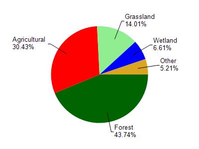
Tomorrow River is located in the Waupaca River watershed which is 290.77 mi². Land use in the watershed is primarily forest (43.70%), agricultural (30.40%) and a mix of grassland (14%) and other uses (11.80%). This watershed has 231.34 stream miles, 2,456.10 lake acres and 14,124.68 wetland acres.
Nonpoint Source Characteristics
This watershed is ranked Medium for runoff impacts on streams, Not Ranked for runoff impacts on lakes and High for runoff impacts on groundwater and therefore has an overall rank of High. This value can be used in ranking the watershed or individual waterbodies for grant funding under state and county programs.However, all waters are affected by diffuse pollutant sources regardless of initial water quality. Applications for specific runoff projects under state or county grant programs may be pursued. For more information, go to surface water program grants.