Green
No
No
No
Fish and Aquatic Life
Overview
Legler School Branch is a nine-mile spring fed stream in the Little Sugar River watershed that flows easterly into the
Little Sugar River near New Glarus, WI. The Legler School Branch sub-watershed is 4 square miles and is used
primarily for agriculture. The entire stream is listed on the 303(d) list due to degraded habitat, with sediment as the
primary nonpoint source pollutant. The 1985 Surface Waters of Green County reported that bank cover was generally
good and erosion was only a problem during periods of heavy runoff.
In 2001, it was noted that there were signs of
severe bank erosion downstream from Legler Valley Road and cows had access to the stream. A structured habitat
survey completed upstream from the 2nd Street bridge crossing in 2004 shows the stream’s bottom consists of greater
than 60 percent fine sediments (68 percent silt and clay) in pools, riffles, and runs. According to WDNR habitat rating
guidelines this is considered poor habitat. In addition, a WDNR aquatic biologist made visual observations of the
stream, noting that it was wide and shallow with highly eroded banks. Department staffs believe that sediment
deposition has caused the stream to widen and become shallower to the point that it is considered poor habitat.
Legler School Branch currently supports a limited forage fishery with the potential to support a warm water forage fishery or
perhaps a cold water fishery. The fishery has been shown to be severely limited with one 2001 survey finding only
one fathead minnow in an upstream location. Interestingly, a fish survey completed at a downstream location in 2004
found four brown trout ranging from 8.7-11.7 inches in length, one largemouth bass, and a large number of cold water
indicator species such as mottled sculpin and brook stickleback. The CWIBI score for this segment of the stream was
50, which indicates “fair” coldwater biotic integrity. The abundance of cool-water species and the consequently high
IBI score at this location could be due to the cool and wet nature of the summer when the survey was performed.
Further fish, habitat, and temperature monitoring would be required to accurately determine the thermal regime of this
stream.
Date 2005
Author Aquatic Biologist
Overview
This stream is on the state’s list of impaired (303d) waters because of habitat degradation due to nonpoint source pollution. The 1985 Surface Waters of Green County reports the bank cover is generally good and erosion is only a problem during periods of heavy runoff. The stream’s bottom mainly consists of rubble or hardpan, with silt deposited in flatter areas. Despite this, there are signs of severe bank erosion downstream from Legler Valley Road and cows have access to the stream (Amrhein, 2001). The fishery is severely limited with one survey finding only one fathead minnow (Bush, 2001).
Date 2002
Author Aquatic Biologist
Historical Description
This stream is on the state’s list of impaired (303d) waters because of habitat degradation due to nonpoint source pollution. The 1985 Surface Waters of Green County reports the bank cover is generally good and erosion is only a problem during periods of heavy runoff. The stream’s bottom mainly consists of rubble or hardpan, with silt deposited in flatter areas. Despite this, there are signs of severe bank erosion downstream from Legler Valley Road and cows have access to the stream (Amrhein, pers. obs). The fishery is severely limited with one survey finding only one fathead minnow (reference).
Date 1985
Author Surface Water Inventory Of Wisconsin
Historical Description
Originating from a spring in Section 18, this small warm water stream flows eastward through a long narrow valley and joins the Little Sugar River below New Glarus. The entire valley floor is devoted to agriculture with the stream meandering through open pasture in the upper half and cropland in the lower half.
Only the lowest one-half mile is ditched. Bank cover is generally good, with grass and sedges in the pastured areas and a narrow bank of trees and shrubs in the cropland. The steeper valley slopes are wooded. The stream's moderate gradient maintains a bottom of rubble or hardpan and silt is deposited in the flatter areas. Erosion is a problem only during periods of heavy runoff. The fishery is severely restricted with a survey finding only one fathead minnow. Wildlife values are also poor, limited to a few muskrats. Access is available from three public road crossings. Fish Species: Fathead minnow.
Surface Acres = 3.6. Length = 5.0 Miles, Gradient = 40 ft./mi.. Base Discharge = 4.2 cu. ft./sec. Bush, D.M., R. Cornelius, D. Engle, and C.L. Brynildson. 1980. Lake and Stream Classification Project. Surface Water Resources of Green County, 2nd Edition. Wisconsin Department of Natural Resources, Madison, Wisconsin.
Date 1980
Author Surface Water Inventory Of Wisconsin
Recommendations
Monitor or Propose 303(d) Listing
Legler School and Pioneer Valley Creeks
Monitor Targeted Watershed Area (TWA)
This project will evaluate the effectiveness of practices on both of these streams which are on the 303(d) list because of habitat degradation caused by sedimentation. HUC12 070900040402.
Management Goals
Wisconsin's Water Quality Standards provide qualitative and quantitative goals for waters that are protective of Fishable, Swimmable conditions [Learn more]. Waters that do not meet water quality standards are considered impaired and restoration actions are planned and carried out until the water is once again fishable and swimmable
Management goals can include creation or implementation of a Total Maximum Daily Load analysis, a Nine Key Element Plan, or other restoration work, education and outreach and more. If specific recommendations exist for this water, they will be displayed below online.
Monitoring
Monitoring the condition of a river, stream, or lake includes gathering physical, chemical, biological, and habitat data. Comprehensive studies often gather all these parameters in great detail, while lighter assessment events will involve sampling physical, chemical and biological data such as macroinvertebrates. Aquatic macroinvertebrates and fish communities integrate watershed or catchment condition, providing great insight into overall ecosystem health. Chemical and habitat parameters tell researchers more about human induced problems including contaminated runoff, point source dischargers, or habitat issues that foster or limit the potential of aquatic communities to thrive in a given area. Wisconsin's Water Monitoring Strategy was recenty updated.
Grants and Management Projects
Monitoring Projects
| WBIC | Official Waterbody Name | Station ID | Station Name | Earliest Fieldwork Date | Latest Fieldwork Date | View Station | View Data |
|---|
| 882900 | Legler School Br | 10048777 | Legler School Br - Along Legler Rd (Dahlke Prpty) | 7/17/2017 | 7/17/2017 | Map | Data |
| 882900 | Legler School Br | 10012076 | Legler School Br - Upstream Of Second St. Bridge | 10/14/2004 | 4/21/2021 | Map | Data |
| 882900 | Legler School Br | 10048778 | Legler School Br - W6387 Legler Rd | 7/17/2017 | 10/4/2017 | Map | Data |
| 882900 | Legler School Br | 10037399 | Legler School Branch at STH 69 | 5/23/2012 | 10/4/2017 | Map | Data |
| 882900 | Legler School Br | 10034083 | Legler School Branch along Legler Valley Road | 10/10/2011 | 10/4/2017 | Map | Data |
| 882900 | Legler School Br | 10037415 | Legler School Branch approx. 1/4 mile upstream of 2nd St. in New Glarus | 5/23/2012 | 6/9/2017 | Map | Data |
|
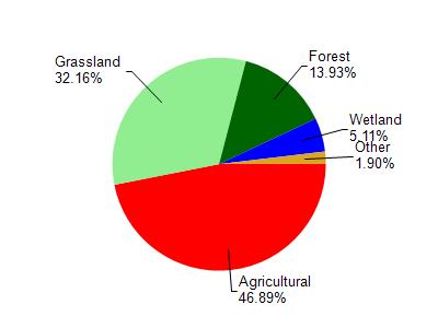
Watershed Characteristics
Legler School Br is located in the Little Sugar River watershed which is 133.02 mi². Land use in the watershed is primarily agricultural (46.80%), grassland (32.10%) and a mix of forest (13.90%) and other uses (7.00%). This watershed has 351.74 stream miles, 50.40 lake acres and 3,252.10 wetland acres.
Nonpoint Source Characteristics
This watershed is ranked Not Ranked for runoff impacts on streams, Not Ranked for runoff impacts on lakes and High for runoff impacts on groundwater and therefore has an overall rank of High. This value can be used in ranking the watershed or individual waterbodies for grant funding under state and county programs.This water is ranked High Stream for individual Rivers based on runoff problems and the likelihood of success from project implementation.