Manitowoc
No
No
Yes
Fish and Aquatic Life
Overview
HORSESHOE LAKE
T17N, R22E, Section 20; Manitowoc County
Surface Acres = 22, S.D.F. = 2.08, Maximum Depth = 54 feet
Horseshoe Lake is a small, hard water drainage lake with spring sources in terminal moraine. The lake surface area is approximately 22 acres with a maximum depth of 54 feet, an average depth of 25 feet and a lake volume of 550 acre feet. The lake is located in an 847-acre direct drainage basin. The dominant land uses within the Horseshoe Lake subwatershed are agriculture and forest (Olson and Helsel 1997). The fish community in Horseshoe lake is primarily largemouth bass and panfish. Access is available via a public park (WDNR 1968).
Horseshoe Lake is classified as a mesotrophic lake with relatively low nutrient and chlorophyll a concentrations and good water clarity. The 1996 spring total phosphorus was 40 ug/L with surface summer phosphorus concentrations ranging from 11 ug/L to 16 ug/L. TSI values typically range between 35 and 50 (Figure 27).
Water Resource Objectives and Management Recommendations
The water resource objectives and management recommendations for Horseshoe Lake reduce phosphorus loading overall 62% from existing conditions (114 lbs/yr) to best managed conditions (43 lbs/yr) (Olson and Helsel 1997). Specific best management practices should target lake protection and nutrient sources from agricultural land.
Date 2001
Author Aquatic Biologist
Historical Description
Source: 1968, Surface Water Resources of Manitowoc County Horseshoe Lake, T17N, R22E, Section 20 Surface acres - 19.0, S.D.F. = 2.08, Maximum depth = 54 feet.
A small, hard water drainage lake with spring sources in terminal moraine 3 miles west of Spring Valley. The lake has clear water and a muck bottom. A navigable connection from West Lake enters the lake at the northwest corner. An intermittent stream at the south end partially drains the lake during periods of high water. Algae blooms have caused occasional problems in the past. It is managed for largemouth bass and panfish; rainbow trout have been stocked. No motors are permitted on the lake. There are 13 dwellings on the shoreline. A public park of 5.6 acres with over 1,000 feet of frontage provides access to the lake. Mallards and blue-wing teal nest here during favorable years, and a small number of migrating waterfowl visit in the fall. Hunting is permitted. There is no adjoining wetland.
Date 1968
Author Surface Water Inventory Of Wisconsin
General Condition
Horseshoe Lake (WBIC 64200) was assessed during the 2018 listing cycle; new chlorophyll sample data were clearly below 2018 WisCALM listing thresholds for the Recreation use and the Fish and Aquatic Life use. This water was meeting these designated uses and was not considered impaired.
Date 2017
Author Ashley Beranek
Condition
Wisconsin has over 84,000 miles of streams, 15,000 lakes and milllions of acres of wetlands. Assessing the condition of this vast amount of water is challenging. The state's water monitoring program uses a media-based, cross-program approach to analyze water condition. An updated monitoring strategy (2015-2020) is now available. Compliance with Clean Water Act fishable, swimmable standards are located in the Executive Summary of Water Condition in 2018. See also the 'monitoring and projects' tab.
Reports
Recommendations
Monitor Water Quality or Sediment
The lake is fairly good condition compared to other Manitowoc County lakes. It is two-story because it is stocked with trout but probably not many trout survive year to year. At about 4 meters the hypolimnion goes anoxic. So the lake may be impaired but a TP criteria of 15 would be impossible for any lake in Manitowoc County to meet. I would prefer to see it listed if it exceeds the criteria of 20 instead of 15.
Management Goals
Wisconsin's Water Quality Standards provide qualitative and quantitative goals for waters that are protective of Fishable, Swimmable conditions [Learn more]. Waters that do not meet water quality standards are considered impaired and restoration actions are planned and carried out until the water is once again fishable and swimmable
Management goals can include creation or implementation of a Total Maximum Daily Load analysis, a Nine Key Element Plan, or other restoration work, education and outreach and more. If specific recommendations exist for this water, they will be displayed below online.
Monitoring
Monitoring the condition of a river, stream, or lake includes gathering physical, chemical, biological, and habitat data. Comprehensive studies often gather all these parameters in great detail, while lighter assessment events will involve sampling physical, chemical and biological data such as macroinvertebrates. Aquatic macroinvertebrates and fish communities integrate watershed or catchment condition, providing great insight into overall ecosystem health. Chemical and habitat parameters tell researchers more about human induced problems including contaminated runoff, point source dischargers, or habitat issues that foster or limit the potential of aquatic communities to thrive in a given area. Wisconsin's Water Monitoring Strategy was recenty updated.
Grants and Management Projects
Monitoring Projects
| WBIC | Official Waterbody Name | Station ID | Station Name | Earliest Fieldwork Date | Latest Fieldwork Date | View Station | View Data |
|---|
| 64200 | Horseshoe Lake | 10003542 | Horseshoe Lake | 7/28/1971 | 9/4/2024 | Map | Data |
| 64200 | Horseshoe Lake | 10019450 | Horseshoe Lake -- Access at End Of Northwood Ln | 8/12/2007 | 7/11/2025 | Map | Data |
| 64200 | Horseshoe Lake | 363065 | Horseshoe Lake - Deep Hole (Historical) | | | Map | Data |
| 64200 | Horseshoe Lake | 363125 | Horseshoe Lake - Deep Hole | 6/4/1995 | 8/6/2025 | Map | Data |
|
Watershed Characteristics
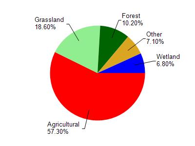
Horseshoe Lake is located in the Pigeon River watershed which is 78.87 mi². Land use in the watershed is primarily agricultural (57.30%), grassland (18.60%) and a mix of forest (10.20%) and other uses (13.90%). This watershed has 110.34 stream miles, 769.54 lake acres and 3,149.60 wetland acres.
Nonpoint Source Characteristics
This watershed is ranked High for runoff impacts on streams, Not Ranked for runoff impacts on lakes and High for runoff impacts on groundwater and therefore has an overall rank of High. This value can be used in ranking the watershed or individual waterbodies for grant funding under state and county programs.However, all waters are affected by diffuse pollutant sources regardless of initial water quality. Applications for specific runoff projects under state or county grant programs may be pursued. For more information, go to surface water program grants.