Details
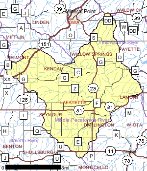
The Middle Pecatonica Watershed lies in the central portion of Lafayette County with a small portion extending into southern Iowa County. The landscape is dominated by agriculture with scattered woodlots and grasslands making up most of the remaining portion.
Two municipalities, Belmont and Darlington, discharge to surface waters in the watershed. The population of the watershed has actually decreased over the past 30 years.
The major known water quality problems in the watershed are from nonpoint source pollution. Erosion from cropland, runoff from barnyards, and streambank pasturing result in degradation of habitat, increased sedimentation, turbidity, and nutrient load. The Middle Pecatonica River Watershed is ranked as a high priority for groundwater protection.
The watershed contains one major impoundment, Joy Lake, located near the headwaters of the Cottage Inn Branch. A 1000 foot earthen dam, completed in 1970, forms this 60 acre lake just east of State Highway 151. Because there is no public access, the DNR does not monitor nor manage the lake.
Date 2002

Ecological Landscapes
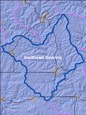
The Southwest Savanna Ecological Landscape is located in the far southwestern part of the state. It is characterized by deeply dissected topography, unglaciated for the last 2.4 million years, with broad open hilltops and river valleys, and steep wooded slopes. The climate is favorable for agriculture but the steep slopes limit it to the hilltops and valley bottoms. Soils are underlain with calcareous bedrock. Soils on hilltops are silty loams, sometimes of shallow depth over exposed bedrock and stony red clay subsoil. Some valley soils are alluvial sands, loams, and peats. Some hilltops are almost treeless due to the thin soil while others have a deep silt loam cap.
Historic vegetation consisted of tall prairie grasses and forbs with oak savannas and some wooded slopes of oak. Almost three-quarters of the current vegetation is agricultural crops with lesser amounts of grasslands, barrens, and urban areas. The major forest types are oak-hickory and maple-basswood. High-quality prairie remnants occur on rocky hilltops and slopes that are not farmed. Some prairie pastures and oak savannas still exist. The grassland areas harbor many rare grassland birds, invertebrates, and other grassland species. Relict stands of pine occur on bedrock outcroppings along some stream systems.
Date 2010
River and Stream QualityAll Waters in WatershedA portion of the watershed near the juncture of the North and South Forks of the Ames Branch is in an atrazine prohibition area. These areas indicate that elevated levels of atrazine, an herbicide used on corn, has been found in some tested private water wells. Soils are permeable which has allowed atrazine to reach groundwater in some locations.
Date 2002
Watershed Trout StreamsWatershed Outstanding & Exceptional ResourcesLakes and Impoundments
Impaired Waters
List of Impaired Waters Monitoring & ProjectsProjects including grants, restoration work and studies shown below have occurred in this watershed. Click the links below to read through the text. While these are not an exhaustive list of activities, they provide insight into the management activities happening in this watershed.
Watershed RecommendationsMonitor biology on WBIC: 925500
Date
Status
Conduct biological (mIBI or fIBI) monitoring on Unnamed, WBIC: 925500, AU:3991153
5/21/2016
Proposed
Otter Creek (1237100) TMDL
Date
Status
Otter Creek is impaired due to degraded habitat because of excessive sediment loading from surrounding agricultural lands to the Creek. Otter Creek is currently not meeting the applicable narrative water quality standard (WQS) that prohibits objectionable deposits on the shore or in the bed of a water in amounts that interfere with public rights in the water. To address the degraded habitat impairments, Wisconsin Department of Natural Resources (WDNR) determined that sediment, specifically TSS, is the pollutant that must be addressed to attain designated uses and meet WQS.
9/22/2012
In Progress
ARRA 11 Lafayette Co. TMDL Planning Grant
Date
Status
Contract for county staff to conduct on-site assessments in the Silver Spring, Cherry Branch, and Apple Branch sub-watersheds to develop TMDLs for these impaired waters.
12/7/2009
In Progress
Dougherty Creek TMDL
Date
Status
Monitor impaired portion of creek for D.O., nutrients, and BOD to determine level of impairment. Fisheries IBI conducted to determine contemporary status of stream. Sondes, conduct monthly nutrient analysis (12) and event sampling (10). Conduct watershed assessment to determine sources. Conduct macroinverterbrate analysis at 3 sites. July 06-June 07 Upper 4 miles of Dougherty Creek
7/1/2006
In Progress
Pecatonica River
Date
Status
Pecatonica River Large River Survey
7/1/2015
Proposed
 Watershed History Note
The Village of Belmont, from the French phrase "Belle Monte" meaning beautiful hill, is located in the Middle Pecatonica River Watershed. It was founded during 1835 by land speculator John Atchison.
The Wisconsin Territory was created by a bill signed on April 20, 1863 by President Andrew Jackson, who then appointed Henry Doge as governor. The territory included all of the present day states of Wisconsin, Iowa, Minnesota, and parts of North and South Dakota. About 22,000 people lived in the territory. The lead-mining region of southwestern Wisconsin was the most densely populated area.
Belmont was the first capitol of the Wisconsin Territory, and the territorial legislature met here for 46 days in 1836. Legislators met in the council house and passed 42 laws, which would become the basis of law and order when Wisconsin became a state 12 years later. A second building, the Supreme Court building was never used for its intended purpose. In addition, there was a lodging house built for the legislators, and a residence for the governor. James Doty, one of the legislators, lobbied hard for a city where he owned land, Madison, to be declared the capitol. The legislature ended their first and last session in Belmont in December 1836 and Madison became the permanent capitol.
The present First Capitol site consists of the two remaining buildings which were used during the 1836 Territorial Legislature; the Council House, where the legislators met, and the Supreme Court House. The site is now a part of the Wisconsin Historical Society.
Date 2011