![Buena Vista Creek [Ditch #2 ], Fourmile and Fivemile Creek Watershed (CW10)](wsSWIMSDocument.ashx?documentSeqNo=162694578 "Buena Vista Creek [Ditch #2 ], Fourmile and Fivemile Creek Watershed (CW10)")
9.61 Miles
9.48 - 19.09
Cool-Cold Mainstem, Coldwater
2023
Good
Portage
Yes
No
No
Fish and Aquatic Life
Overview
Buena Vista Creek is classified as a Class I and II trout stream. The upstream portion of the stream has been ditched and is now referred to as Ditch No. 2. The upper reach is characterized by moderate brook trout densities with natural reproduction and is limited by sedimentation, lack of adult fish cover, and shallow stream depth. The lower meandering portions of Buena Vista Creek are stocked with brown trout and have low densities of brook trout. Sedimentation, high water temperatures, and high phosphorus concentrations impact this stretch. Stream bank erosion is a source of sediment in the lower portion of Buena Vista Creek generating from just above CTH F down to Lake Wazeecha (Kruger). Unfortunately, it is not feasible or practical to control streambank erosion and sediment bed load movement in this section of Buena Vista Creek. This is due to limited access and the expense for riprapping, and structures to control bed load movement will not work in the low wide flood plain (Kruger). Further investigations are recommended for a complete understanding of the local land use effects and remedies.
The Upper Buena Vista Creek Watershed is a source of nutrients, particularly nitrates, because of the large percentage of irrigated farmland. Sediments tend to settle out in the upper ditches of the watershed and are not considered major nonpoint sources of pollution to Buena Vista Creek (Kruger, 1986). Nitrate values approaching 4 ppm have been detected in Buena Vista Creek. Pesticides have also been detected.
Biotic index sampling results indicate excellent, good, fair and poor water quality depending on location and the time sampled.
Date 2002
Author Aquatic Biologist
Condition
Wisconsin has over 84,000 miles of streams, 15,000 lakes and milllions of acres of wetlands. Assessing the condition of this vast amount of water is challenging. The state's water monitoring program uses a media-based, cross-program approach to analyze water condition. An updated monitoring strategy (2015-2020) is now available. Compliance with Clean Water Act fishable, swimmable standards are located in the Executive Summary of Water Condition in 2018. See also the 'monitoring and projects' tab.
Reports
Recommendations
Shoreland Ordinance
Wood County proposes to amend or create a shoreland zoning ordinance that complies with the requirements of NR 115, Wisconsin Administrative Code (as revised effective February 1, 2010) and retain existing regulations that exceed the water resource protections of NR 115 or are specific or unique to local needs.
Water Quality Planning
The Fourmile and Fivemile Creek Watershed is 213.96 square miles located in Wood and Portage Counties. Seventy-eight streams (654.12 miles) and twenty-four lakes and flowages (3538.98) are located in the watershed. Much of the watershed lies within the townships of Plover, Buena Vista, and Grant in Portage County. The Portage County Soil Erosion Control Plan (1986) ranked these towns as high priority for erosion control work because of both wind and water erosion.
Management Goals
Wisconsin's Water Quality Standards provide qualitative and quantitative goals for waters that are protective of Fishable, Swimmable conditions [Learn more]. Waters that do not meet water quality standards are considered impaired and restoration actions are planned and carried out until the water is once again fishable and swimmable
Management goals can include creation or implementation of a Total Maximum Daily Load analysis, a Nine Key Element Plan, or other restoration work, education and outreach and more. If specific recommendations exist for this water, they will be displayed below online.
Monitoring
Monitoring the condition of a river, stream, or lake includes gathering physical, chemical, biological, and habitat data. Comprehensive studies often gather all these parameters in great detail, while lighter assessment events will involve sampling physical, chemical and biological data such as macroinvertebrates. Aquatic macroinvertebrates and fish communities integrate watershed or catchment condition, providing great insight into overall ecosystem health. Chemical and habitat parameters tell researchers more about human induced problems including contaminated runoff, point source dischargers, or habitat issues that foster or limit the potential of aquatic communities to thrive in a given area. Wisconsin's Water Monitoring Strategy was recenty updated.
Grants and Management Projects
Monitoring Projects
| WBIC | Official Waterbody Name | Station ID | Station Name | Earliest Fieldwork Date | Latest Fieldwork Date | View Station | View Data |
|---|
| 1391300 | Buena Vista Creek | 10022681 | Buena Vista Creek(Ditch #2) Above Townline Rd. | 1/1/2015 | 8/31/2023 | Map | Data |
| 1391300 | Buena Vista Creek | 10022683 | Buena Vista Creek Above 95th St. | 5/17/2011 | 8/31/2023 | Map | Data |
| 1391300 | Buena Vista Creek | 10053912 | Buena Vista 110th | 7/13/2020 | 7/13/2020 | Map | Data |
| 1391300 | Buena Vista Creek | 10043507 | Buena Vista Creek at 130th Ave | | | Map | Data |
| 1391300 | Buena Vista Creek | 503076 | Buena Vista Creek at 100th St | | | Map | Data |
| 1391300 | Buena Vista Creek | 10022682 | Buena Vista Creek Below Co. Tr. F | 1/1/2015 | 1/1/2015 | Map | Data |
| 1391300 | Buena Vista Creek | 10020818 | Buena Vista Creek-At Buena Vista Dr & Cth F | 9/1/2022 | 8/31/2023 | Map | Data |
| 1391300 | Buena Vista Creek | 10041786 | Buena Vista Creek at 110th ST | 1/1/2015 | 8/31/2023 | Map | Data |
| 1391300 | Buena Vista Creek | 10022680 | Buena Vista Creek (Ditch #2) - Taft Road | 5/5/2014 | 8/31/2023 | Map | Data |
| 1391300 | Buena Vista Creek | 10016701 | Buena Vista Creek - 100th St. (15 M Above Bridge) | 5/1/1979 | 7/13/2020 | Map | Data |
|
Watershed Characteristics
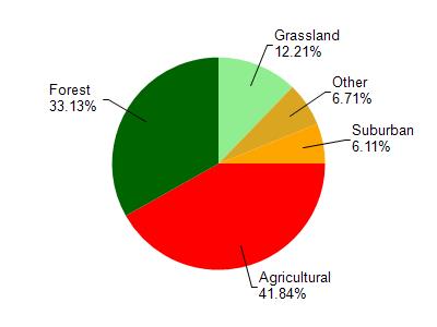
Buena Vista Creek is located in the Fourmile and Fivemile Creek watershed which is 213.96 mi². Land use in the watershed is primarily agricultural (41.80%), forest (33.10%) and a mix of grassland (12.20%) and other uses (12.80%). This watershed has stream miles, lake acres and 13,528.97 wetland acres.
Nonpoint Source Characteristics
This watershed is ranked Medium for runoff impacts on streams, Medium for runoff impacts on lakes and High for runoff impacts on groundwater and therefore has an overall rank of High. This value can be used in ranking the watershed or individual waterbodies for grant funding under state and county programs.However, all waters are affected by diffuse pollutant sources regardless of initial water quality. Applications for specific runoff projects under state or county grant programs may be pursued. For more information, go to surface water program grants.
Buena Vista Creek [Ditch #2 ] is considered a Cool-Cold Mainstem, Coldwater under the state's Natural Community Determinations.
Natural communities (stream and lake natural communities) represent model results and DNR staff valiation processes that confirm or update predicted conditions based on flow and temperature modeling from historic and current landscape features and related variables. Predicated flow and temperatures for waters are associated predicated fish assemblages (communities). Biologists evaluate the model results against current survey data to determine if the modeled results are corect and whether biological indicators show water quaity degradation. This analysis is a core component of the state's resource management framework. Wisconsin's Riverine Natural Communities.
Cool (Cold-Transition) Mainstem streams are moderate-to-large but still wadeable perennial streams with cold to cool summer temperatures. Coldwater fishes are common to uncommon, transitional fishes are abundant to common, and warm water fishes are uncommon to absent. Headwater species are common to absent,
mainstem species are abundant to common, and river species are common to absent.