Monroe
No
No
Yes
Fish and Aquatic Life
Overview
Morris Creek, also known as Moore Creek, is located in south central Monroe County. This stream flows in a southeasterly direction for 7.5 miles before reaching the Kickapoo River north of Ontario. Morris Creek has a gradient of 26 feet per mile and drains the Village of Norwalk and agricultural lands with wooded hillsides. Morris Creek receives treated wastewater from the village of Norwalk and Valley Pride Pack, an animal rendering plant. Morris Creek is not a classified trout stream.
The most recent survey, conducted in 1997, documented brook trout and numerous forage fish species. The stream bottom was comprised of equal amounts of gravel, rubble, sand and silt. In-stream cover included woody decris, boulders and some undercut banks. Temperature monitoring should be able to determine if Morris Creek is appropriate for introducing wild strains of trout to establish a self sustaining population. WDNR records indicate that Morris Creek has been stocked with brook trout regularly since 1994. Access to Morris Creek is from six road crossings, Monroe County land, and the Elroy-Sparta State Trail.
From: Ripp, Coreen, Koperski, Cindy and Folstad, Jason. 2002. The State of the Lower Wisconsin River Basin.
PUBL WT-559-2002. Wisconsin Department of Natural Resources, Madison, WI.
Date 2002
Author Cynthia Koperski
Historical Description
Livestock pasturing on the streambanks is degrading in-stream habitat. A water quality
assessment in 1990 in the vicinity of Pine Valley Meats indicated that the aquatic
invertebrate populations had been severely affected. The water quality assessment was
conducted to evaluate the impacts of runoff from farm fields and the landspreading of
wastes from Pine Valley Meats. A 1990 Fisheries Management survey found the following
endangered resources in the Moore Creek Watershed: wood turtle (threatened status)
and redside dace (special concern status).
Date 1994
Author Surface Water Inventory Of Wisconsin
Impaired Waters
Moore (Morris) Creek was evaluated in 2012 for phosphorus and biology. Phosphorus levels were too high and this was reflected in poor biology. Reevaluation in 2020 showed continued high levels of phosphorus, but all seven sites sampled for biology showed fish and bug communities in good health. The 'degraded biological community' impairment was removed form this water in 2020.
Date 2019
Author Ashley Beranek
Condition
Wisconsin has over 84,000 miles of streams, 15,000 lakes and milllions of acres of wetlands. Assessing the condition of this vast amount of water is challenging. The state's water monitoring program uses a media-based, cross-program approach to analyze water condition. An updated monitoring strategy (2015-2020) is now available. Compliance with Clean Water Act fishable, swimmable standards are located in the Executive Summary of Water Condition in 2018. See also the 'monitoring and projects' tab.
Reports
Management Goals
Wisconsin's Water Quality Standards provide qualitative and quantitative goals for waters that are protective of Fishable, Swimmable conditions [Learn more]. Waters that do not meet water quality standards are considered impaired and restoration actions are planned and carried out until the water is once again fishable and swimmable
Management goals can include creation or implementation of a Total Maximum Daily Load analysis, a Nine Key Element Plan, or other restoration work, education and outreach and more. If specific recommendations exist for this water, they will be displayed below online.
Monitoring
Monitoring the condition of a river, stream, or lake includes gathering physical, chemical, biological, and habitat data. Comprehensive studies often gather all these parameters in great detail, while lighter assessment events will involve sampling physical, chemical and biological data such as macroinvertebrates. Aquatic macroinvertebrates and fish communities integrate watershed or catchment condition, providing great insight into overall ecosystem health. Chemical and habitat parameters tell researchers more about human induced problems including contaminated runoff, point source dischargers, or habitat issues that foster or limit the potential of aquatic communities to thrive in a given area. Wisconsin's Water Monitoring Strategy was recenty updated.
Grants and Management Projects
Monitoring Projects
| WBIC | Official Waterbody Name | Station ID | Station Name | Earliest Fieldwork Date | Latest Fieldwork Date | View Station | View Data |
|---|
| 1200000 | Moore Creek | 10016645 | Moore Creek - 30 Yds US of intersecton of CTH T and Eagle Ave | 9/16/1993 | 9/16/1993 | Map | Data |
| 1200000 | Moore Creek | 423065 | Morris Creek - Cth T Se Sec 3 T15nr2w | 8/29/1984 | 10/4/1984 | Map | Data |
| 1200000 | Moore Creek | 10015623 | Morris (Moore) Creek Station 8 - SW 1/4 of S15 trail is near stream | 8/23/2017 | 10/18/2017 | Map | Data |
| 1200000 | Moore Creek | 10015628 | Morris (Moore) Creek Station 3 - across from end of Kennel Ave | | | Map | Data |
| 1200000 | Moore Creek | 10016180 | Moore Creek - 10 Yards Upstream Of Hwy 71 | 9/16/1993 | 11/1/2017 | Map | Data |
| 1200000 | Moore Creek | 423004 | Morris Creek - Norwalk Farmers Coop Creamery | 7/22/1981 | 10/4/1984 | Map | Data |
| 1200000 | Moore Creek | 10015632 | Morris (Moore) Creek Station 3 - 1000ft Downstream Of Cth T In Ne 1/4 Of S10 | | | Map | Data |
| 1200000 | Moore Creek | 10032694 | Morris (Moores) Creek below un. trib (NE 1/4 SW 1/4 SEC. 34 T16N-R2W) | | | Map | Data |
| 1200000 | Moore Creek | 10015633 | Morris (Moore) Creek Station 4 - 1000ft DS of Cth T crossing in S34 T16n R2w | | | Map | Data |
| 1200700 | Unnamed | 10020921 | Creek 34-15 Or Cr. 3-2 Mead Ave. Crossing | | | Map | Data |
| 1200000 | Moore Creek | 423219 | Moore Creek at Cth T Near Norwalk WI | 5/22/2002 | 11/1/2017 | Map | Data |
| 1200000 | Moore Creek | 10016642 | Moore (Morris) Creek - 25 Yds US of Cth T bridge near Mead Rd. | 10/7/1997 | 11/1/2017 | Map | Data |
| 1200000 | Moore Creek | 10032309 | Moore Creek - Confluence with Unnamed 28-8 (WBIC 1201100) | 1/1/2015 | 1/1/2015 | Map | Data |
| 1200000 | Moore Creek | 10015626 | Morris (Moore) Creek Station 5 - Hwy 71 Bridge In S34 | | | Map | Data |
| 1200000 | Moore Creek | 423005 | Morris Creek - Norwalk Stp | 10/27/1977 | 5/23/2001 | Map | Data |
| 1200000 | Moore Creek | 10015620 | Morris (Moore) Creek Station 2 - 2000ft Downstream Of Cth T In S10 | | | Map | Data |
| 1200000 | Moore Creek | 10016647 | Moore - 38 30m US from Hwy T | 10/20/2002 | 10/20/2002 | Map | Data |
| 1200000 | Moore Creek | 10015621 | Morris (Moore) Creek Station 3 - 2000ft Downstream Of Cth T Bridge Crossing In T16n R2w S34 | | | Map | Data |
| 1200000 | Moore Creek | 10015619 | Morris (Moore) Creek Station 1 - Cth T Bridge In S23 | 6/12/2012 | 11/1/2017 | Map | Data |
| 1200000 | Moore Creek | 10022488 | Morris Creek - 140m Downstream Of Cth U Or Water St. | 1/1/2015 | 1/1/2015 | Map | Data |
| 1200000 | Moore Creek | 423222 | Moore Creek Tributary at Norwalk WI | 6/21/2001 | 10/17/2001 | Map | Data |
| 1200000 | Moore Creek | 10015625 | Morris (Moore) Creek Station 2 - Farm Rd. Crossing In Se 1/4 Of S14 | | | Map | Data |
| 1200000 | Moore Creek | 10033589 | Morris Creek at bike trail in Norwalk | | | Map | Data |
| 1200000 | Moore Creek | 10015622 | Morris (Moore) Creek Station 4 - Village Of Norwalk | 8/23/2017 | 10/18/2017 | Map | Data |
| 1200000 | Moore Creek | 10022490 | Morris Creek - Confluence With Wbic 1201700 | 1/1/2015 | 10/18/2017 | Map | Data |
| 1200000 | Moore Creek | 10015629 | Morris (Moore) Creek Station 4 - in NW 1/4 of S15 | | | Map | Data |
| 1201700 | Unnamed | 10048904 | Unnamed Trib WBIC 1201700- 20m US of Confluence with Moore Creek | 10/18/2017 | 10/18/2017 | Map | Data |
| 1200000 | Moore Creek | 10049171 | Moore Creek - near South St in Norwalk | 9/12/2017 | 9/12/2017 | Map | Data |
| 1200000 | Moore Creek | 10016650 | Moore Creek - CTH T bridge near Mead (Eagle) Rd | 4/30/1997 | 4/30/1997 | Map | Data |
|
Watershed Characteristics
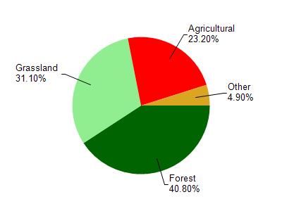
Moore Creek is located in the Upper Kickapoo River watershed which is 117.33 mi². Land use in the watershed is primarily forest (40.80%), grassland (31.10%) and a mix of agricultural (23.20%) and other uses (4.90%). This watershed has 267.92 stream miles, 29.35 lake acres and 698.36 wetland acres.
Nonpoint Source Characteristics
This watershed is ranked High for runoff impacts on streams, Not Ranked for runoff impacts on lakes and High for runoff impacts on groundwater and therefore has an overall rank of High. This value can be used in ranking the watershed or individual waterbodies for grant funding under state and county programs.However, all waters are affected by diffuse pollutant sources regardless of initial water quality. Applications for specific runoff projects under state or county grant programs may be pursued. For more information, go to surface water program grants.