Iowa
Yes
Yes
No
Fish and Aquatic Life
Overview
Trout Creek has five miles of Class I trout waters and three miles of Class II trout waters.
The eight miles of trout water are also classified as an outstanding resource water (ORW) and
the stream supports the natural reproduction of brown trout. A rare aquatic species has been
found in the creek in past surveys. The stream, although considered one of the best trout
streams in southern Wisconsin, is threatened by an impoundment in its headwaters that
threatens the downstream management of cold water fisheries. The impoundment was built
as a flood control structure and affects in-stream habitat and the trout fishery by causing
sediment to fill in pools and warming the water. The stream also has some problems with
nonpoint source pollution and is considered a high priority for nonpoint source pollution and
would benefit from a nonpoint source pollution reduction project. Baseline monitoring was
conducted on the stream in the summer of 2000. Much of the stream is in public ownership as
the Trout Creek State Fishery Area. The fishery area is approximately 900 acres and offers
opportunities for fishing, hiking, and birdwatching. (See Birch Lake)
From: Ripp, Coreen, Koperski, Cindy and Folstad, Jason. 2002. The State of the Lower Wisconsin River Basin.
PUBL WT-559-2002. Wisconsin Department of Natural Resources, Madison, WI.
Date 2002
Author Cynthia Koperski
Historical Description
Trout Creek has five miles of Class I trout waters and three miles of Class II trout waters
(WDNR, 1980). The eight miles of trout water are also classified as outstanding
resource waters under Wisconsin Administrative Code NR 102 (WDNR, 1991) much of
the stream is in public ownership as the Trout Creek State Fishery area (WDNR, 1991).
A Soil Conservation Service dry dam, built as a flood control structure, affects in-stream
habitat and the trout fishery by causing sediment to fill in pools and warming the water
(Brynildson, 1984 and Van Dyke, 1992)
Date 1994
Author Surface Water Inventory Of Wisconsin
Historical Description
Trout Creek - Mouth location T7N R4E Section 13 -11, Surface area = 6.7 acres, Length = 7.9 miles, Gradient = 55.7 feet per mile. Total alkalinity = 248.0 mg/l, Volume of flow = 7.7 cfs.
Trout Creek is spring fed, flows northwesterly and is the largest tributary of Mill Creek. It is rated as one of the best trout streams in the southern part of the state and the best one in Iowa County. Trout Creek is included
in the Twin Parks Watershed Plan prepared for Mill Creek and its tributaries.
Three flood control structures were proposed and constructed during recent years. Two of these are located on the mainstream; one, located near the headwaters, has a permanent pool in Birch Lake (a managed trout lake) and the other is strictly a detention-slow release structure located about two miles above the mouth. The third structure is located on Duesler Creek and forms a permanent pool. The detention structure on the mainstream has impaired trout reproduction to some extent but not enough to hurt the fishery. Flood damage has been reduced which helped to establish a more permanent fishery in the lower half of the stream. All of its tributaries are small and include Irish Hollow, Duesler and Arneson Creeks. The combined discharges of these streams amount to about 17 percent of the base flow. The sport fishery consists of brook, brown, and rainbow trout which all reproduce naturally. Fingerling brown and rainbow trout are stocked annually in the lower section to supplement the natural reproducing brown trout population located upstream. Forage fish species present include white suckers, creek chubs, stoneroller minnows, longnose dace, fathead minnows, spotfin shiners and brook sticklebacks.
Aquatic game assets include puddle ducks on Birch Lake, and muskrats which are common throughout its length. Public land acquisition by the Bureau of Fish Management include the torphy-Hutter parcels above the dam structure nearest the mouth. So far, 43.5 acres of land and 4,900 linear feet of shoreline on the stream and 134.0 acres of land around Birch Lake are owned by the State of Wisconsin. The area around Birch Lake has been developed into a park. Besides access from state lands it can be reached from three road crossings.
From: Piening, Ronald and Threinen, C.W., 1968. Lake and Stream Classification Project. Surface Water Resources of Iowa County, Wisconsin Department of Natural Resources, Madison, WI.
Date 1968
Author Surface Water Inventory Of Wisconsin
General Condition
This water was assessed during the 2014 listing cycle; total phosphorus sample data clearly met 2014 WisCALM listing thresholds for the Fish and Aquatic Life use. No biological data (i.e. no macroinvertebrate or fish Index of Biotic Integrity (IBI) scores) were available to assess biological condition.
Date 2015
Author Aquatic Biologist
Condition
Wisconsin has over 84,000 miles of streams, 15,000 lakes and milllions of acres of wetlands. Assessing the condition of this vast amount of water is challenging. The state's water monitoring program uses a media-based, cross-program approach to analyze water condition. An updated monitoring strategy (2015-2020) is now available. Compliance with Clean Water Act fishable, swimmable standards are located in the Executive Summary of Water Condition in 2018. See also the 'monitoring and projects' tab.
Reports
Recommendations
Diagnostic/Feasibility Assessment
Birch Lake, located on Trout Creek is a Class 1 trout stream supporting brook trout. The water quality in Birch Lake is poor, and negatively impacting Trout Creek below the dam, as well as hindering fish migration up and downstream. Iowa County will hire an engineering firm to get a second opinion as to the feasibility and costs to remove the Birch Lake dam. Deliverables: A dam removal feasibility study, and cost estimates of removal will include dam removal, stability of sediment, stream restoration. The study will be shared with stakeholders and local units of government. Stakeholders include trout unlimited, town of Brigham, and the Village of Barneveld.
Management Goals
Wisconsin's Water Quality Standards provide qualitative and quantitative goals for waters that are protective of Fishable, Swimmable conditions [Learn more]. Waters that do not meet water quality standards are considered impaired and restoration actions are planned and carried out until the water is once again fishable and swimmable
Management goals can include creation or implementation of a Total Maximum Daily Load analysis, a Nine Key Element Plan, or other restoration work, education and outreach and more. If specific recommendations exist for this water, they will be displayed below online.
Monitoring
Monitoring the condition of a river, stream, or lake includes gathering physical, chemical, biological, and habitat data. Comprehensive studies often gather all these parameters in great detail, while lighter assessment events will involve sampling physical, chemical and biological data such as macroinvertebrates. Aquatic macroinvertebrates and fish communities integrate watershed or catchment condition, providing great insight into overall ecosystem health. Chemical and habitat parameters tell researchers more about human induced problems including contaminated runoff, point source dischargers, or habitat issues that foster or limit the potential of aquatic communities to thrive in a given area. Wisconsin's Water Monitoring Strategy was recenty updated.
Grants and Management Projects
Monitoring Projects
| WBIC | Official Waterbody Name | Station ID | Station Name | Earliest Fieldwork Date | Latest Fieldwork Date | View Station | View Data |
|---|
| 1243100 | Trout Creek | 10055584 | Trout Creek Springs | 6/1/2021 | 6/16/2022 | Map | Data |
| 1243100 | Trout Creek | 10008158 | Trout Creek Station 5 | 11/10/2000 | 11/10/2000 | Map | Data |
| 1243100 | Trout Creek | 10008000 | Trout Cr. Station 3 - Cth T | 11/29/2019 | 11/29/2019 | Map | Data |
| 1243100 | Trout Creek | 10022704 | Trout Cr. Station 5 T7n R5e Sec 30 Nwse | | | Map | Data |
| 1243100 | Trout Creek | 10022703 | Trout Cr. Station 4 T7n R5e Sec 30 Nwse | | | Map | Data |
| 1243100 | Trout Creek | 10010891 | Trout Creek - Trout Creek Li-2 | | | Map | Data |
| 1243100 | Trout Creek | 10022699 | Trout Cr at Mill Dam Rd | 1/1/2015 | 10/22/2024 | Map | Data |
| 1243100 | Trout Creek | 10008001 | Trout Cr. Station 4 | 11/10/2000 | 11/10/2000 | Map | Data |
| 1243100 | Trout Creek | 10008144 | Trout Creek Station 2 | | | Map | Data |
| 1243100 | Trout Creek | 253197 | Trout Cr US Arneson Cr confluence | 5/13/1994 | 10/29/2019 | Map | Data |
| 1243100 | Trout Creek | 10058131 | Trout Cr US Mill Cr confluence | | | Map | Data |
| 1243100 | Trout Creek | 10022701 | Trout Cr opposite A-Frame house .4 Mi South of DNR parking Lot Entrance Along CTH T | 1/1/2015 | 10/30/2019 | Map | Data |
| 1243100 | Trout Creek | 10039090 | Trout Creek US CTH T | 7/1/2003 | 11/29/2019 | Map | Data |
| 1243100 | Trout Creek | 10008157 | Trout Creek Station 4 | | | Map | Data |
| 1243100 | Trout Creek | 253182 | Trout Creek - Trout Creek | 6/12/2003 | 5/12/2024 | Map | Data |
| 1243100 | Trout Creek | 10007985 | Trout Creek Station 2 (E. Of Cth T) | 11/10/2000 | 11/10/2000 | Map | Data |
| 1243100 | Trout Creek | 10040807 | Trout Creek at Twin Parks Dam 8 near Barneveld WI (CTH T) | | | Map | Data |
| 1243100 | Trout Creek | 10008002 | Trout Cr. Station 5 | | | Map | Data |
| 1243100 | Trout Creek | 10008160 | Trout Creek Station 5b (Upstream Of Confluence W/Arneson Ck) | 4/28/1993 | 5/13/1994 | Map | Data |
| 1243100 | Trout Creek | 10008142 | Trout Creek Station 1a | 4/28/1993 | 4/28/1993 | Map | Data |
| 1243100 | Trout Creek | 10008156 | Trout Creek Station 3 (atCth T) | 11/10/2000 | 7/19/2012 | Map | Data |
| 1243100 | Trout Creek | 10031723 | Trout Creek upwellings | 1/1/2015 | 1/1/2015 | Map | Data |
| 1243100 | Trout Creek | 10015790 | Trout Creek - Opposite Red Shed - .4 Mi South Ofparking Lot Entrance Along Cth T | 4/30/1998 | 1/1/2015 | Map | Data |
| 1243100 | Trout Creek | 10007984 | Trout Creek Station 1 | | | Map | Data |
| 1243100 | Trout Creek | 10031722 | Trout Cr US of spring ~217M US of Arneson Cr confluence | 5/19/2021 | 5/19/2021 | Map | Data |
| 1243100 | Trout Creek | 10008140 | Trout Cr ~900M US Mill Cr confluence | 11/10/2000 | 11/10/2000 | Map | Data |
| 1243100 | Trout Creek | 10008159 | Trout Creek Station 5a (atConfluence W/Arneson Creek) | | | Map | Data |
| 1243100 | Trout Creek | 10022700 | Trout Cr 350m DS of CTH T (below Dry Dam) | 1/1/2015 | 3/28/2019 | Map | Data |
|
Watershed Characteristics
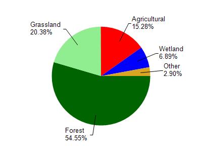
Trout Creek is located in the Mill and Blue Mounds Creek watershed which is 186.74 mi². Land use in the watershed is primarily forest (54.60%), grassland (20.40%) and a mix of agricultural (15.30%) and other uses (9.80%). This watershed has 382.87 stream miles, 106.91 lake acres and 6,596.99 wetland acres.
Nonpoint Source Characteristics
This watershed is ranked Medium for runoff impacts on streams, Low for runoff impacts on lakes and High for runoff impacts on groundwater and therefore has an overall rank of High. This value can be used in ranking the watershed or individual waterbodies for grant funding under state and county programs.This water is ranked High Stream for individual Rivers based on runoff problems and the likelihood of success from project implementation.