Columbia
Yes
No
No
Fish and Aquatic Life
Overview
Rowan Creek is classified as a trout stream for 12 miles of its length with some natural reproduction of brown trout. About four miles are Class I trout waters and designated as an
exceptional water resource (ERW), while eight are Class II. Approximately 8 miles of the
trout stream portion of the stream has been listed on the state's list of impaired waters.
Despite this, the stream has been known as one of the best trout streams in Columbia County.
Surveys conducted in 1998 found the stream to have fair to good fish community health and
good to excellent habitat quality. There are nonpoint source pollution problems in its upper
end due to cattle access, bank erosion, and cropland erosion. In addition, new housing
developments are springing up, which has resulted in problems with stormwater runoff. A
River Planning Grant, sponsored by Columbia County, has been granted to help examine
current and potential stormwater issues along Rowan Creek. The grant will help with future
stormwater planning and management to control this potential source of pollution.
As a result of the threat from nonpoint sources and the streams potential to support a healthy
and fishable population of trout, the stream has been ranked as a high priority for nonpoint
source pollution and would benefit as a nonpoint source pollution reduction project.
The Friends of Rowan Creek have also received a River Planning Grant. The grant will be
used to facilitate educational and outreach activities in the watershed. The grant will also help
the group to address problems and issues that affect the overall health of the watershed.
From: Ripp, Coreen, Koperski, Cindy and Folstad, Jason. 2002. The State of the Lower Wisconsin River Basin.
PUBL WT-559-2002. Wisconsin Department of Natural Resources, Madison, WI.
Date 2002
Author Cynthia Koperski
Historical Description
Rowan Creek is classified as a trout stream for 12 miles of its length (WDNR, 1991)
About four miles are Class I trout waters, while eight are Class II. The Class I waters are
also listed as exceptional resources waters under the state's antidegradation rules. This
is the best trout stream in Columbia County (Larson, 1992) . There are some minor
nonpoint source pollution problenls in its upper end due to cattle access, bank erosion,
and cropland erosion, but not enough to impair water quality, fisheries or recreational
use (Larson, 1992). The village of Poynette discharges treated effluent to the stream
and a canning plant discharges non-contact cooling water to the stream. A spill occurred
at the canning plant, but it apparently did not affect water quality (Heim, 1992).
Date 1994
Author Surface Water Inventory Of Wisconsin
Historical Description
Rowan Creek T11N, R9E, Section 30, Surface Acres = 12.84, Miles = 10.6, Gradient = 11.79 feet per mile.
A fair gradient spring-fed stream tributary to the Wisconsin River. Brown
trout constitute the fishery for about 5.5 miles, below which warm water fishes
from Lake Wisconsin inhabit the stream. The stream has perhaps more potential
than any in Columbia County for sustaining a cold water fishery. Several state,
county and town roads provide access. Over 800 acres of varied marshland adjoin
the stream.
Powers Creek (That portion of Rowan Creek from its junction with Hinkson Creek
to the Wisconsin River is referred to as Powers Creek)
From: Poff, Ronald J. and C.W. Threinen, 1965. Surface Water Resources of Columbia County:
Lake and Stream Classification Project. Wisconsin Conservation Department, Madison, WI.
Date 1965
Author Surface Water Inventory Of Wisconsin
General Condition
Rowan Creek (miles 0-10.41) was assessed during the 2018 listing cycle; new biological (fish Index of Biotic Integrity (IBI) scores) sample data were clearly below the 2018 WisCALM listing thresholds for the Fish and Aquatic Life use. This water was meeting this designated use and was not considered impaired.
Date 2017
Author Ashley Beranek
General Condition
Rowan Creek (Mile 10.4 to 13.98) was assessed during the 2018 listing cycle; new biological (macroinvertebrate and fish Index of Biotic Integrity (IBI) scores), chloride, and temperature sample data were clearly below the 2018 WisCALM listing thresholds for the Fish and Aquatic Life use. This water was meeting this designated use and was not considered impaired.
Date 2017
Author Ashley Beranek
Condition
Wisconsin has over 84,000 miles of streams, 15,000 lakes and milllions of acres of wetlands. Assessing the condition of this vast amount of water is challenging. The state's water monitoring program uses a media-based, cross-program approach to analyze water condition. An updated monitoring strategy (2015-2020) is now available. Compliance with Clean Water Act fishable, swimmable standards are located in the Executive Summary of Water Condition in 2018. See also the 'monitoring and projects' tab.
Reports
Recommendations
Watershed Mapping or Assessment
Columbia County Land and Water Conservation Department will sponsor a project on Rowan Creek, Columbia County, to complete a watershed impacts needs inventory. This watershed resource gathering process will be an important step in the development of a long-term management plan for Rowan Creek. Project deliverables include the development of a GIS database to include delineation of the watershed, lists of landowners, location of identified watershed sources of sedimentation, nutrient loading, and ultimately scenarios that will correct or minimize the amount of sediment and nutrients entering the system.
Stormwater Planning, Implementation
This grant will provide information to facilitate effective stormwater planning and management in the Rowan Creek Watershed. This will be done through a comprehensive study that will include: a stream and watershed assessment, a stakeholder analysis, a compilation of effective stormwater management practices, and outreach activities intended to communicate the study's findings.
Educate and engage residents
The Friends of Rowan Creek will: 1) strengthen their organizational development, 2) educate the public on the value of Rowan Creek watershed and how they can help protect it, 3) publicize the Friends of Rowan Creek and recruit members, and 4) protect the watershed by participating in planning efforts, identifying and controlling exotic species, planting trees, and other activities.
Aquatic Invasive Species Removal
The Friends of Rowan Creek will: 1) strengthen their organizational development, 2) educate the public on the value of Rowan Creek watershed and how they can help protect it, 3) publicize the Friends of Rowan Creek and recruit members, and 4) protect the watershed by participating in planning efforts, identifying and controlling exotic species, planting trees, and other activities.
Management Goals
Wisconsin's Water Quality Standards provide qualitative and quantitative goals for waters that are protective of Fishable, Swimmable conditions [Learn more]. Waters that do not meet water quality standards are considered impaired and restoration actions are planned and carried out until the water is once again fishable and swimmable
Management goals can include creation or implementation of a Total Maximum Daily Load analysis, a Nine Key Element Plan, or other restoration work, education and outreach and more. If specific recommendations exist for this water, they will be displayed below online.
Monitoring
Monitoring the condition of a river, stream, or lake includes gathering physical, chemical, biological, and habitat data. Comprehensive studies often gather all these parameters in great detail, while lighter assessment events will involve sampling physical, chemical and biological data such as macroinvertebrates. Aquatic macroinvertebrates and fish communities integrate watershed or catchment condition, providing great insight into overall ecosystem health. Chemical and habitat parameters tell researchers more about human induced problems including contaminated runoff, point source dischargers, or habitat issues that foster or limit the potential of aquatic communities to thrive in a given area. Wisconsin's Water Monitoring Strategy was recenty updated.
Grants and Management Projects
Monitoring Projects
| WBIC | Official Waterbody Name | Station ID | Station Name | Earliest Fieldwork Date | Latest Fieldwork Date | View Station | View Data |
|---|
| 1263700 | Rowan Creek | 10030498 | Rowan Creek 340m Downstream of I Hwy 94 Southbound | 1/1/2015 | 1/1/2015 | Map | Data |
| 1263700 | Rowan Creek | 113145 | Rowan Creek - Cth J | 11/1/1993 | 8/2/2019 | Map | Data |
| 1263700 | Rowan Creek | 10010616 | Rowan Creek | | | Map | Data |
| 1263700 | Rowan Creek | 10010948 | Rowan Creek At Lower Rowan | 1/1/2015 | 6/23/2020 | Map | Data |
| 1263700 | Rowan Creek | 10052700 | ROWAN CREEK 400M DS SEWAGE TREATMENT PLANT OUTFALL | | | Map | Data |
|
Watershed Characteristics
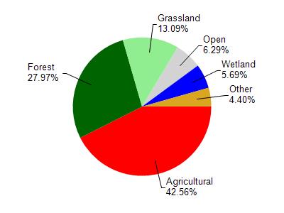
Rowan Creek is located in the Lake Wisconsin watershed which is 214.96 mi². Land use in the watershed is primarily agricultural (42.60%), forest (28%) and a mix of grassland (13.10%) and other uses (16.40%). This watershed has 299.58 stream miles, 521.55 lake acres and 6,644.90 wetland acres.
Nonpoint Source Characteristics
This watershed is ranked Medium for runoff impacts on streams, Low for runoff impacts on lakes and High for runoff impacts on groundwater and therefore has an overall rank of High. This value can be used in ranking the watershed or individual waterbodies for grant funding under state and county programs.This water is ranked High Stream for individual Rivers based on runoff problems and the likelihood of success from project implementation.