Dane
Yes
No
Yes
Fish and Aquatic Life
Overview
Badger Mill Creek's drainage area includes much of the southwest side of Madison as well as most of Verona. Although the creek is currently classified as a limited forage fishery in the lower two miles, field surveys indicate that the creek could be reclassified to a fish and aquatic life use - coldwater stream. The creek is currently listed on the list of impaired waters due to the impacts of nonpoint source pollution.
Although the stream historically received wastewater discharges, by 1985 both public and private wastewater discharges to Badger Mill Creek were removed. In August, 1998, MMSD began returning treated wastewater to Badger Mill Creek in response to concerns that by sending Verona wastewater to MMSD for treatment, the effluent discharge to the Lower Rock Basin reduced water quantity in the Sugar-Pecatonica Basin. Today, the quantity of water generated/pumped out of the basin is returned to the Sugar-Pecatonica Basin via Badger Mill Creek.
Restoring water quantity was expected to restore the water balance between the Upper Sugar River and Yahara River watersheds, improve habitat, offset the impacts on baseflow of significant groundwater withdrawals in Verona and the southwest City of Madison, and improve the fishery potential by removing low baseflow as a limiting condition. Badger Mill Creek is the focus of several monitoring efforts as a result of this discharge. MMSD has developed an agreement with the USGS to provide a continuous sampling station near the Verona treatment plant to monitor and document the volume and temperature of the effluent as a condition of managing the treated effluent. The WDNR conducts fish shocking and aquatic insect sampling to study long-term trends and conditions. MMSD has conducted annual monitoring of fish assemblages at two stations in the Sugar River and two in Badger Mill Creek.
This monitoring indicates that while the stream can maintain a thermally sensitive fish assemblage, the diversion has had other impacts on the stream. While the numbers of trout have increased likely due to an increase in habitat via an increase in flow, the presence of pollution intolerant (thermally sensitive) cold water indicator species such as mottled sculpin and brook stickleback, and aquatic insects indicative of healthy trout streams, have declined since the diversion. In addition, monitoring has revealed increased levels of chlorides, total phosphorus, dissolved phosphorus and ammonia in the creek. As a result, although numbers of trout have increased, overall water quality and stream health may be deteriorating as a result of the diversion of treated wastewater to Badger Mill Creek (DNR Dave Rowe Coldwater Habitat Evaluation Study).
Date 2019
Author Aquatic Biologist
Facilities Management
The main branch of Badger Mill Creek is designated as a Class II trout stream by the WDNR for fish management purposes, in accordance with NR 1.02(7). The creek flows 9.5 miles through the southwest side of City of Madison and bisects the City of Verona. Residential and agricultural land uses are the two most dominant land uses in the 29.6 square mile watershed, each occupying ? of the area. Ongoing development in Madison and Verona continues to change land use in the area. Upstream of the MMSD effluent discharge point, Badger Mill Creek is intermittent as in flows through the City of Madison and generally only flows when there is significant runoff. Downstream of the MMSD discharge point, Badger Mill Creek flows 4.9 miles until it combines with the Upper Sugar River. Because of the MMSD discharge, Badger Mill Creek is classified as a Variance Stream for Uses and Designated Standards [NR 104.05(2)], which allows the WDNR to relax certain water quality standards for this stream to allow discharge of treated municipal wastewater. These stream Use Standards are state water quality standards established to guide water quality planning under NR 121.
Since August 1998, MMSD has discharged about 3.3 mgd (5 cfs) of highly treated effluent to Badger Mill Creek as a way to maintain baseflow in the creek. This additional effluent compensates for groundwater extracted from the Sugar River basin by municipal wells. After groundwater is pumped and used, the wastewater is diverted to MMSD?s Nine Springs treatment plant and discharged to Badfish Creek, in the adjacent Rock River basin, and Badger Mill Creek, in the Sugar River Basin. This return of treated effluent helps to restore the water balance between these two basins and, more importantly, improves aquatic habitat in Badger Mill Creek by removing low baseflow as a limiting habitat condition.
Date 2018
Author Sarah Fuller
General Condition
Badger Mill Creek does not show significant biological impairments for macroinvertebrates or fish. In 1998, miles 2-5 of the creek were listed as impaired for total suspended solids by the DNR. In 2002, the creek was delisted when TSS was analyzed again. According to a 2017 fisheries assessment conducted by the DNR, MMSD effluent has helped support fish communities by maintaining steady baseflow in the creek, has not altered the fish community, and has not caused problematic thermal impacts. In DNR assessments for 2018, miles 0 to 5 of Badger Mill Creek did not show biological impairments but did show phosphorus impairments, prompting a proposal for the creek to be listed as an impaired water. Chloride and temperature were also assessed but did not result in any proposed impairment additions.
Date 2018
Author Sarah Fuller
Impaired Waters
The 2018 assessments of Badger Mill Creek (from the confluence with the Sugar River to north of HWY 18 and 69; miles 0-2) showed impairment by phosphorus; new total phosphorus sample data overwhelmingly exceeded the 2018 WisCALM listing criteria for the Fish and Aquatic Life use. However, available biological data did not indicate impairment (i.e. no macroinvertebrate or fish Index of Biotic Integrity (IBI) scored in the "poor" condition category). Based on the most updated information, this water was proposed for the impaired waters list.
The 2018 assessments of Badger Mill Creek (from north of HWY 18 and 69 to E Verona Ave and HWY 18; miles 2-5) showed impairment by phosphorus; new total phosphorus sample data overwhelmingly exceeded the 2018 WisCALM listing criteria for the Fish and Aquatic Life use. However, available biological data did not indicate impairment (i.e. no macroinvertebrate or fish Index of Biotic Integrity (IBI) scored in the "poor" condition category). Based on the most updated information, this water was proposed for the impaired waters list.
Date 2017
Author Ashley Beranek
Condition
Wisconsin has over 84,000 miles of streams, 15,000 lakes and milllions of acres of wetlands. Assessing the condition of this vast amount of water is challenging. The state's water monitoring program uses a media-based, cross-program approach to analyze water condition. An updated monitoring strategy (2015-2020) is now available. Compliance with Clean Water Act fishable, swimmable standards are located in the Executive Summary of Water Condition in 2018. See also the 'monitoring and projects' tab.
Reports
Recommendations
Citizen-Based Stream Monitoring
Collect chemical, physical, and/or biological water quality data to assess the current overall stream health. The data can inform management decisions and may be used to identify impaired waters for biennial lists.
Citizen-Based Stream Monitoring
Collect chemical, physical, and/or biological water quality data to assess the current overall stream health. The data can inform management decisions and may be used to identify impaired waters for biennial lists.
Citizen-Based Stream Monitoring
Collect chemical, physical, and/or biological water quality data to assess the current overall stream health. The data can inform management decisions and may be used to identify impaired waters for biennial lists.
Management Goals
Wisconsin's Water Quality Standards provide qualitative and quantitative goals for waters that are protective of Fishable, Swimmable conditions [Learn more]. Waters that do not meet water quality standards are considered impaired and restoration actions are planned and carried out until the water is once again fishable and swimmable
Management goals can include creation or implementation of a Total Maximum Daily Load analysis, a Nine Key Element Plan, or other restoration work, education and outreach and more. If specific recommendations exist for this water, they will be displayed below online.
Monitoring
Monitoring the condition of a river, stream, or lake includes gathering physical, chemical, biological, and habitat data. Comprehensive studies often gather all these parameters in great detail, while lighter assessment events will involve sampling physical, chemical and biological data such as macroinvertebrates. Aquatic macroinvertebrates and fish communities integrate watershed or catchment condition, providing great insight into overall ecosystem health. Chemical and habitat parameters tell researchers more about human induced problems including contaminated runoff, point source dischargers, or habitat issues that foster or limit the potential of aquatic communities to thrive in a given area. Wisconsin's Water Monitoring Strategy was recenty updated.
Grants and Management Projects
Monitoring Projects
| WBIC | Official Waterbody Name | Station ID | Station Name | Earliest Fieldwork Date | Latest Fieldwork Date | View Station | View Data |
|---|
| 888100 | Badger Mill Creek | 10013372 | Badger Mill Creek at Hwy 69 | 4/11/1996 | 5/12/2021 | Map | Data |
| 888100 | Badger Mill Creek | 10013370 | Badger Mill Creek 6-8 | | | Map | Data |
| 888100 | Badger Mill Creek | 10013371 | Badger Mill Creek at Riverside Road | 9/18/2021 | 5/15/2022 | Map | Data |
| 888100 | Badger Mill Creek | 10011966 | Badger Mill Creek - Sth. 69 Upstream To Fenceline In Pasture | 11/30/1988 | 10/9/2024 | Map | Data |
| 888100 | Badger Mill Creek | 10047601 | Badger Mill Creek at STH 151 (lower crossing) | 11/11/2016 | 7/26/2024 | Map | Data |
|
Monitoring Studies
In 1998, miles 2-5 of the creek were listed as impaired for total suspended solids by the DNR. In 2002, the creek was delisted when TSS was analyzed again. According to a 2017 fisheries assessment conducted by the DNR, MMSD effluent has helped support fish communities by maintaining steady baseflow in the creek, has not altered the fish community, and has not caused problematic thermal impacts. In DNR assessments for 2018, miles 0 to 5 of Badger Mill Creek did not show biological impairments but did show phosphorus impairments, prompting a proposal for the creek to be listed as an impaired water. Chloride and temperature were also assessed but did not result in any proposed impairment additions. Continued monitoring occurs on a routine basis.
Since Badger Mill Creek is a coldwater stream, it is sensitive to temperatures increases from uncontrolled urban runoff. The stream?s watershed is therefore classified as a thermally sensitive area. Stormwater management practices are required for new development within the watershed to provide thermal controls so that warm water does not enter the stream and negatively impact the aquatic ecosystem.
The United States Geological Survey (USGS) monitors flow, temperature, specific conductance and dissolved oxygen near the Bruce Street crossing in Verona. Annual average discharge at this site as increased since monitoring began in 1996, mostly as a result of increased baseflow. This has led to concerns of more frequent flooding in the floodplain downstream of the City of Verona.
Date 2018
Author Sarah Fuller
Watershed Characteristics
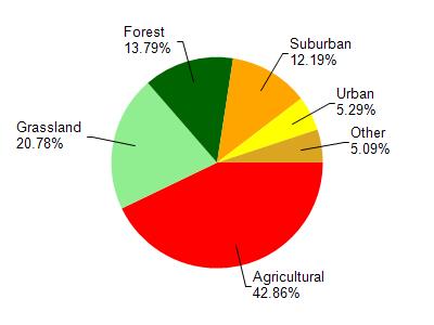
Badger Mill Creek is located in the Upper Sugar River watershed which is 105.96 mi². Land use in the watershed is primarily agricultural (42.90%), grassland (20.80%) and a mix of forest (13.80%) and other uses (22.60%). This watershed has 183.62 stream miles, 151.49 lake acres and 2,231.15 wetland acres.
Nonpoint Source Characteristics
This watershed is ranked High for runoff impacts on streams, Not Ranked for runoff impacts on lakes and High for runoff impacts on groundwater and therefore has an overall rank of High. This value can be used in ranking the watershed or individual waterbodies for grant funding under state and county programs.However, all waters are affected by diffuse pollutant sources regardless of initial water quality. Applications for specific runoff projects under state or county grant programs may be pursued. For more information, go to surface water program grants.