Dane
Yes
No
No
Fish and Aquatic Life
Overview
This is a tributary to Kittleson Valley Creek in southwest Dane County. It is considered a warm water forage fishery stream, but does have the potential for trout (Marshall, 1988). Water quality and in-stream habitat are thought to be good (WDNR,1992-931). Grazing along the stream appears to be the primary water quality and habitat problem.
Date
Author Aquatic Biologist
Overview
Pleasant Valley Branch is a five-mile long stream located in southwestern Dane County. It is part of the Gordon Creek
watershed and empties into Kittleson Valley Creek southeast of Daleyville. Currently, Pleasant Valley Branch
supports a warm water forage fishery, however, the presence of brown trout and mottled sculpin demonstrate this
stream’s potential to support a cold water fishery. Pleasant Valley Branch is currently listed on the 303(d) list for
degraded habitat due to sedimentation from overgrazing and a lack of habitat. However, several streambank
stabilization and habitat restoration projects are currently underway in the stream.
In 2003, a section of Pleasant Valley Branch, starting at the northern CTH H crossing, and extending about ½ mile
down stream, had stream bank work done as part of a Wildlife Habitat Improvement Program (WHIP) grant. Prior to
this work, one brown trout and a few specimens of forage fish were found in this section of stream. The stream was
wide, shallow, and the bottom was composed primarily of sand and silt. A 2004 post-rehabilitation habitat evaluation
of this project area showed marginal silt deposition (22%), with the majority of the substrate being composed of gravel
or coarser material (59%). These findings, coupled with width to depth ratios of about 7:1, suggest “good” habitat
quality for this section of rehabilitated stream. Also, three additional fish surveys were conducted to observe the
effects of the restoration project. Two survey sites were replicates from the previous year in the area that had been restored and found 34 brown trout (2.5 - 13.9 inches), three brook trout (10.0 - 10.9 inches), 11 black crappie (6.6 - 7.3
inches), and four minnow and forage species.
A third section, downstream of where the restoration was to occur, found 29 brown trout (6.1 - 13.7 inches) and five
other forage and minnow species, with white sucker and creek chub being the most abundant. Additional lands in the
watershed have been enrolled in the Conservation Reserve Enhancement Program and another section of stream
corridor is scheduled for rehabilitation work in 2005 under the state’s Targeted Runoff Management Program.
Date 2005
Author Aquatic Biologist
Overview
Pleasant Valley Branch is a 5 mile stream in southwest Dane County that serves as a tributary to Kittleson Valley Creek. The stream currently supports warm water forage fish but could support a cold water fishery. While water temperature and water quality are thought to be good (1995 basin report), the stream is on the state’s list of degraded (303d) waters because of impairment caused by nonpoint source pollution. This is especially evident from just upstream of County Highway A downstream to its mouth (Amrhein, pers. obs). Fish and habitat monitoring conducted in 2002 showed the presence of cold water indicator species. Heavy sedimentation caused by overgrazing and lack of habitat keep the stream from reaching it’s potential. The stream is considered high priority for nonpoint source pollution and would benefit from stream buffers. The Dane County Land Conservation Department is planning to restore 3000 linear feet of stream as part of the Wildlife Habitat Improvement Program.
Date 2002
Author Aquatic Biologist
Historical Description
Pleasant Valley Branch -T5N, R6E, Sec. 28, Surface acres = 6, Length = 7 miles, Stream order = II, GradIent = 27 ft/mile, Base discharge = 2.1 cfs.
Pleasant Valley Branch originates in Section 3 of Perry Township (T5N, R6E) and flows south. Joining Kittleson Valley Creek in the same township, it drains crop and pasture land and upland forest areas. No wetlands adjoin the creek. The creek is sprlng-fed with a moderate gradient. Water quality is quite good although slightly alkaline, but fish are sparse. Access is good at Hwy. A and along Hwy. H. Fish species: brown trout, sucker, and forage species.
From: Day, Elizabeth A.; Grzebieniak, Gayle P.; Osterby, Kurt M.; and Brynildson, Clifford L., 1985. Lake and Stream Classification Project. Surface Water Resources of Dane County, Wisconsin Department of Natural Resources, Madison, WI.
Date 1985
Author Surface Water Inventory Of Wisconsin
General Condition
Pleasant Valley Branch was listed for Degraded Habitat and Total Suspended Solids/Sediment in 1998 due to sedimentation from overgrazing and a lack of habitat. The TMDL for this listing was approved 2005. Pleasant Valley Branch supports a warm water forage fishery; however, the presence of brown trout and mottled sculpin demonstrate this stream's potential to support a cold water fishery. Several streambank stabilization and habitat restoration projects have taken place in the stream. When Pleasant Valley Branch was assessed during the 2016 listing cycle and was proposed for delisting based on new biological, habitat, and water quality data.
Date 2017
Author Ashley Beranek
Condition
Wisconsin has over 84,000 miles of streams, 15,000 lakes and milllions of acres of wetlands. Assessing the condition of this vast amount of water is challenging. The state's water monitoring program uses a media-based, cross-program approach to analyze water condition. An updated monitoring strategy (2015-2020) is now available. Compliance with Clean Water Act fishable, swimmable standards are located in the Executive Summary of Water Condition in 2018. See also the 'monitoring and projects' tab.
Reports
Recommendations
Monitor EPA SP12 (Measure W)
Evaluate the fish/habitat/macroinvertebrate quality of Kittleson Valley and Pleasant Valley Creek. Similar work was performed in 2009 at the inception of the WI buffer initiative project. Overall goal is to compare data from that year and remove Pleasant Valley from the list of impaired waters. Note: USGS has been monitoring P, N, and SS loads over the past 5 years. Therefore, water chemistry monitoring is not requested with this project.
Monitor to Evaluate Projects
Evaluate the fish/habitat/macroinvertebrate quality of Kittleson Valley and Pleasant Valley Creek. Similar work was performed in 2009 at the inception of the WI buffer initiative project. Overall goal is to compare data from that year and remove Pleasant Valley from the list of impaired waters. Note: USGS has been monitoring P, N, and SS loads over the past 5 years. Therefore, water chemistry monitoring is not requested with this project.
Monitor Water Quality or Sediment
Monitoring of these two streams will take place in order to comply with the EPA SP-12 measure to show improved water quality conditions. Each stream has had major rehabilitation of the watershed and stream corridor. This monitoring will determine whether or not these streams are meeting their natural attainable use and can subsequently be removed from the state's list of impaired waters.
Monitor EPA SP12/WQ10
Evaluate the fish/habitat/ macroinvertebrate quality of Kittleson Valley and Pleasant Valley Creek. Similar work was performed in 2009 at the inception of the WI buffer initiative project. Overall goal is to compare data from that year and remove Pleasant Valley from the list of impaired waters.
Monitor Watershed (Status,Sources,Impairments)
Evaluate the fish/habitat/macroinvertebrate quality of Kittleson Valley and Pleasant Valley Creek. Similar work was performed in 2009 at the inception of the WI buffer initiative project. Overall goal is to compare data from that year and remove Pleasant Valley from the list of impaired waters. Note: USGS has been monitoring P, N, and SS loads over the past 5 years. Therefore, water chemistry monitoring is not requested with this project.
Management Goals
Wisconsin's Water Quality Standards provide qualitative and quantitative goals for waters that are protective of Fishable, Swimmable conditions [Learn more]. Waters that do not meet water quality standards are considered impaired and restoration actions are planned and carried out until the water is once again fishable and swimmable
Management goals can include creation or implementation of a Total Maximum Daily Load analysis, a Nine Key Element Plan, or other restoration work, education and outreach and more. If specific recommendations exist for this water, they will be displayed below online.
Monitoring
Monitoring the condition of a river, stream, or lake includes gathering physical, chemical, biological, and habitat data. Comprehensive studies often gather all these parameters in great detail, while lighter assessment events will involve sampling physical, chemical and biological data such as macroinvertebrates. Aquatic macroinvertebrates and fish communities integrate watershed or catchment condition, providing great insight into overall ecosystem health. Chemical and habitat parameters tell researchers more about human induced problems including contaminated runoff, point source dischargers, or habitat issues that foster or limit the potential of aquatic communities to thrive in a given area. Wisconsin's Water Monitoring Strategy was recenty updated.
Grants and Management Projects
Monitoring Projects
| WBIC | Official Waterbody Name | Station ID | Station Name | Earliest Fieldwork Date | Latest Fieldwork Date | View Station | View Data |
|---|
| 908500 | Pleasant Valley Br | 10011636 | Pleasant Valley Br - Pleasant Valley Creek 188 M Upstream Of 2nd Bridge Crossing On Cty. Rd. H To Tributary On Right | 11/2/2004 | 1/1/2015 | Map | Data |
| 908500 | Pleasant Valley Br | 10010692 | Pleasant Valley Br - Pleasant Valley Creek at CTH H (downstream site) | 11/13/2003 | 12/4/2019 | Map | Data |
| 908500 | Pleasant Valley Br | 10031464 | Pleasant Valley Branch at Spring Valley Dr. (3rd crossing E of Hwy 78) | 7/19/2010 | 1/1/2015 | Map | Data |
| 908500 | Pleasant Valley Br | 10009462 | Pleasant Valley Creek Upstream Kittleson Rd | 10/7/2009 | 12/4/2019 | Map | Data |
| 908500 | Pleasant Valley Br | 10010700 | Pleasant Valley Br - Cty H Bridge Crossing (upstream site) | 11/2/2004 | 12/4/2019 | Map | Data |
| 908500 | Pleasant Valley Br | 10009781 | Pleasant Valley Br - Pleasant Valley Branch Upstream From Cty A | 6/11/1986 | 11/27/2019 | Map | Data |
| 908500 | Pleasant Valley Br | 10010693 | Pleasant Valley Br - Pleasant Valley Branch Below Cty H At Mail Box No. 596 | 11/13/2003 | 1/1/2015 | Map | Data |
|
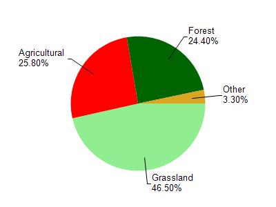
Watershed Characteristics
Pleasant Valley Br is located in the Gordon Creek watershed which is 76.90 mi². Land use in the watershed is primarily grassland (46.50%), agricultural (25.80%) and a mix of forest (24.40%) and other uses (3.30%). This watershed has 205.79 stream miles, 7.11 lake acres and 487.25 wetland acres.
Nonpoint Source Characteristics
This watershed is ranked High for runoff impacts on streams, Not Ranked for runoff impacts on lakes and High for runoff impacts on groundwater and therefore has an overall rank of High. This value can be used in ranking the watershed or individual waterbodies for grant funding under state and county programs.This water is ranked High Stream for individual Rivers based on runoff problems and the likelihood of success from project implementation.