Grant
Yes
No
Yes
Fish and Aquatic Life
Overview
Snowden Branch is a tributary stream that flows southwest into Blockhouse
Creek near Dickeyville, Wisconsin. Blockhouse Creek subsequently flows into
the Little Platte River. Snowden Branch has an average gradient of 33 feet per
mile and drains an area of approximately 17 square miles. It is listed as having
the potential to support a coldwater fishery from its mouth upstream for five miles
and as a warm water forage fishery for its remaining length. Snowden Branch is
currently listed as supporting a warm water forage fishery for its entire length
Land use in the watershed is dominated by agriculture; however the geography of the area dictates the types of practices employed.
The upper third of the stream resides in rolling hills and is predominantly used for row cropping. The lower two thirds of the stream lie in lowland valleys and are used for pasturing. In many locations throughout the stream, heavy pasturing along shorelines and agricultural cropping practices adjacent to stream banks are causing sediment runoff tothe stream. This is especially evident during high precipitation and snowmelt events.
WDNR files dating back to the 1960’s note degraded water quality due to runoff
from animal feeding operations that carried manure and sediment to the stream.
Although the major problem areas have been addressed, concerns with nonpoint
source pollution in the watershed still exist. Water quality data outlining
these conditions have been collected by WDNR, the University of Wisconsin-
Platteville, and the Southwest Badger Resource Conservation and Development
Council as part of a River Planning Grant.
Biological data have been collected by WDNR and include fish, habitat, and macroinvertebrate surveys between the years of 1968 and 2000. In addition, local citizens have shown considerable interest in the streams health. Water Action Volunteers through the WDNR Citizen Monitoring Program have collected stream data related to weather conditions, turbidity, dissolved oxygen, temperature, flow, and biological organisms during the summer months of 2000-2004.
Date 2011
Author Aquatic Biologist
Overview
Snowden Branch is a 9 mile long stream located in Grant County, Wisconsin (WDNR TMDL). The stream is known as a seepage and spring fed tributary that begins northeast of the town of Bigpatch, WI located in southeastern Grant County and flows west, eventually flowing into Blockhouse Creek (WDNR 2001). In 2002, the lower 5 miles were designated as Class II trout waters; however, it is not currently being managed for trout and has not been stocked. (WDNR 2002; WDNR 2003). The lower portion of the stream has also been known to harbor a smallmouth bass fishery (WDNR 2001).
Date 2009
Author James Amrhein
Overview
Snowden Branch is a tributary stream that flows southwest into Blockhouse Creek near Dickeyville, Wisconsin. Blockhouse Creek then flows into the Little Platte River. Snowden Branch has an average gradient of 33 feet per mile and drains an area of approximately 17 square miles. It is listed as having the potential to support a coldwater fishery from its mouth upstream for five miles and a warm water forage fishery for its remaining length. Snowden Branch is currently listed as supporting a warm water forage fishery for its entire length (Figure A-3).
Land use in the watershed is dominated by agricultural practices; however the geography of the area dictates the types of practices employed. The upper third of the stream resides in rolling hills of the upland area and is predominantly used for row cropping. The lower two thirds of the stream corridor lie in lowland valleys and are used for agricultural pasturing. In many locations throughout the stream, heavy pasturing along shorelines and agricultural cropping practices adjacent to stream banks are causing sediment runoff to the stream. This is especially evident during high precipitation or snowmelt events.
WDNR files dating back to the 1960’s note degraded water quality due to runoff from large animal feeding operations that carried manure and sediment to the stream. Although the major problem areas have been addressed, concerns with non-point source pollution in the watershed still exist. Water quality data outlining these conditions have been collected by WDNR and the University of Wisconsin-Platteville and the Southwest Badger Resource Conservation and Development Council (SWBRCD) as part of a River Planning Grant. Biological data have been collected WDNR and include fish, habitat, and macroinvertebrate surveys between the years of 1968 and 2000. In addition, local citizens have shown considerable interest in the stream’s health. Water Action Volunteers through the WDNR Citizen Monitoring Program have collected stream data related to weather conditions, turbidity, dissolved oxygen, temperature, flow, and biological organisms during the summer months of 2000-2004.
Date 2006
Author Aquatic Biologist
Historical Description
Snowden Branch is a seepage and spring fed tributary to Blockhouse Creek near Dickeyville. The reach downstream of County Trunk Highway D flows through a scenic narrow valley with wooded hillsides. A portion of the stream was once considered to be trout waters (Smith and Ball, 1972), but it is not presently listed or managed for trout. The lower reaches of the stream does have a limited smallmouth bass fishery (Fix, 1991). A pollution intolerant species found on Wisconsin’s threatened and endangered species list has historically been found in Snowden Branch (Sims, 2000).
During the 1970’s and 1980’s, water quality, instream habitat and fisheries were severely affected by non-point source pollution in the 70’s and 80’s. At the time, the main source of this degradation was runoff from a large animal feeding operation that carried manure and sediment to the stream, and excessive grazing along a reach of the stream. The overall effect was the loss of biological and recreational and led to the listing of Snowden Branch on the state’s list of impaired waters. Since that time, these problems have been addressed and as shown be recent monitoring, the stream appears to have improved (Sims, 2000). Despite this improvement, more could be done to improve the health of the stream and the aquatic communities that inhabit Snowden Branch. In addition to problems with non-point source pollution, fish migration is limited by an improperly located town road bridge. A local conservation group in cooperation with the DNR is embarking on a project to continue to restore an improve the cold water fishery on Snowden Branch through streambank stabilization, streambank easements, and instream habitat improvements. The stream has also become the focus of a citizen monitoring project. A site of the stream below the bridge on Big Patch Road was sampled for water clarity, water temperature, dissolved oxygen, flow, and habitat (Trout Unlimited 2001).
Date 2001
Author Aquatic Biologist
Historical Description
From: Smith, Tom D., and Ball, Joseph R., Lake and Stream Classification Project. Surface Water Resources of Grant County, Department of Natural Resources, 1972. Surface Area = 12.73 acres, Length = 7.0 miles, Gradient = 33 ft./mi
Flow = 3.8 c.f.s
A spring- and seepage-fed stream beginning one mile northwest of Cuba City and flowing northwest to enter Blockhouse Creek two miles northeast of Dickeyville. French Creek, its only major tributary, enters from the southeast in the central portions of the stream. The uppermost two miles is considered good trout water and is locally known as I'Big Patch Creek". The greatest value of this stream is providing trout fishing for local people in southeastern Grant County. The brown trout which are stocked annually by the Department of Natural Resources and the Platteville Conservation Club grow very well in this stream. Forage species are common throughout. Bank cover is l~cking along most of the stream. The lower portion of the stream which is inhabited bya small population of smallmouth bass is characterized by many wide, flat pools, long riffle areas, and a rubble-boulder bottom. Much of the substrate is derived from dolomite and this accounts for the high alkalinity and specific conductance of the water. About four acres of shrub swamp wet- land adjoins the stream near the mouth. Game assets include muskrats, an occasional puddle duck, and upland species common to southwestern Wisconsin. A recreational area and lake were proposed to be built on the stream in the past one mile below the mouth of French Creek near the inger-like ridge known as "The Devils Backbone". This project was never started because of financial difficulties. Several feedlots located along the upper reaches of the stream are potential sources of pollution. Overgrazing and bank erosion are also severe problems within the watershed. There is no public land along the stream, however, it can be reached from five bridge crossings. Many stiles have also been placed along the upper half of the stream adjacent to a paralleling town road. Ten dwellings are seen along the upper reaches.
Date 1972
Author Surface Water Inventory Of Wisconsin
Impaired Waters
6/24/2005 Per communication with Jim Baumann, 303d length was changed from mile 0-3 to mile 0-5. There are conflicting reports as to the quality of the stream and its suitability as a trout fishery. DO levels may be an issue, and TMDL categories may need to be changed if and when new data becomes available.
9 mile long stream. Would expect to have more than a forage fishery.
Lower part is meanders and deep valley, upstream is upland area.
No data when listed on 303d list. No trout or bass, some forage fish but macroinvertebrates look okay.
There seems to be an impairment. Jim Baumann (6/05).
Date 2005
Author Aquatic Biologist
Condition
Wisconsin has over 84,000 miles of streams, 15,000 lakes and milllions of acres of wetlands. Assessing the condition of this vast amount of water is challenging. The state's water monitoring program uses a media-based, cross-program approach to analyze water condition. An updated monitoring strategy (2015-2020) is now available. Compliance with Clean Water Act fishable, swimmable standards are located in the Executive Summary of Water Condition in 2018. See also the 'monitoring and projects' tab.
Reports
Recommendations
Partnership Project
Southwest Badger Resource, Conservation & Development, Inc., together with UW-Platteville Department of Civil and Environmental Engineering, the Reclamation Program, and the Department of Biology will complete a planning study of the Snowden Branch of the Little Platte River watershed.
Management Goals
Wisconsin's Water Quality Standards provide qualitative and quantitative goals for waters that are protective of Fishable, Swimmable conditions [Learn more]. Waters that do not meet water quality standards are considered impaired and restoration actions are planned and carried out until the water is once again fishable and swimmable
Management goals can include creation or implementation of a Total Maximum Daily Load analysis, a Nine Key Element Plan, or other restoration work, education and outreach and more. If specific recommendations exist for this water, they will be displayed below online.
Monitoring
Monitoring the condition of a river, stream, or lake includes gathering physical, chemical, biological, and habitat data. Comprehensive studies often gather all these parameters in great detail, while lighter assessment events will involve sampling physical, chemical and biological data such as macroinvertebrates. Aquatic macroinvertebrates and fish communities integrate watershed or catchment condition, providing great insight into overall ecosystem health. Chemical and habitat parameters tell researchers more about human induced problems including contaminated runoff, point source dischargers, or habitat issues that foster or limit the potential of aquatic communities to thrive in a given area. Wisconsin's Water Monitoring Strategy was recenty updated.
Grants and Management Projects
Monitoring Projects
| WBIC | Official Waterbody Name | Station ID | Station Name | Earliest Fieldwork Date | Latest Fieldwork Date | View Station | View Data |
|---|
| 944600 | Snowden Br | 10008013 | Snowden Branch Station 2-Rock Rd | 11/6/2000 | 11/6/2000 | Map | Data |
| 944600 | Snowden Br | 223352 | Snowden Branch - Rock Road Downstream | 7/14/1992 | 6/9/2015 | Map | Data |
| 944600 | Snowden Br | 10008012 | Snowden Br Station 1-Bell Ln | 11/6/2000 | 1/1/2015 | Map | Data |
| 944600 | Snowden Br | 10030428 | Snowden Branch - Streich Property | 10/14/2009 | 1/1/2015 | Map | Data |
| 944600 | Snowden Br | 10030429 | Snowden Branch - 60 m upstream from junction with French Creek | 1/1/2015 | 1/1/2015 | Map | Data |
|
Watershed Characteristics
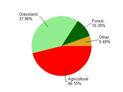
Snowden Br is located in the Little Platte River watershed which is 154.94 mi². Land use in the watershed is primarily agricultural (46.20%), grassland (38%) and a mix of forest (10.40%) and other uses (5.50%). This watershed has 389.19 stream miles, 19.99 lake acres and 585.06 wetland acres.
Nonpoint Source Characteristics
This watershed is ranked High for runoff impacts on streams, Not Available for runoff impacts on lakes and High for runoff impacts on groundwater and therefore has an overall rank of High. This value can be used in ranking the watershed or individual waterbodies for grant funding under state and county programs.However, all waters are affected by diffuse pollutant sources regardless of initial water quality. Applications for specific runoff projects under state or county grant programs may be pursued. For more information, go to surface water program grants.