Grant
Yes
No
No
Fish and Aquatic Life
Overview
This watershed contains the reach of Grant River from its mouth upstream to Pigeon Creek. The valley tends to be steeper in this downstream portion of the river. Due to this local relief, land is less intensively cropped than in other parts of the watershed, however, non-point source pollution from streambank erosion is severe. The USGS maintains a flow monitoring station on the Grant River near Burton. Data from this station shows that almost 54,000 tons of sediment were discharged to the river above Burton (Holmstrom, et.al., 1998). This value averages out to slightly more than 5.5 tons of soil per acre from the entire Grant River drainage area above Burton during 1998. That sediment ultimately reaches the Mississippi River at Pool 11. The fishery of this reach of the river includes smallmouth bass, walleye, sauger, and catfish. The floodplain-wetlands complex at the mouth of the river provides a highly productive habitat for waterfowl and nongame species (Bachhuber et.al., 1991). Overall, this reach of Grant River is heavily used for canoeing, hunting, fishing and other types of recreation
Date 2001
Author Aquatic Biologist
Historical Description
From: Smith, Tom D., and Ball, Joseph R., Lake and Stream Classification Project. Surface Water Resources of Grant County, Department of Natural Resources, 1972. Surface Area = 211.90 acres, Length = 43.7 miles, Gradient = 5 ft./mile, Flow = 170.5 c.f.s.
A seepage and spring fed stream beginning at the confluence of Rogers Branch and Borah Creek two miles north of Lancaster. It lows southwest until nearing Beetown and then turns sharply to the southeast entering the Mississippi River three-fourth mile west of Potosi. This is a large, low gradient stream with an extensive watershed that drains nearly one-third of Grant County. Next to the Platte River it is the second largest river completely within Grant County. Over 70 percent of the land in the watershed is used for agricultural purposes. Flooding of valley bottom lands and subsequent bank erosion is a severe problem along the Grant River and most ofits larger tributaries. Siltation is heavy in the larger pools.
Trout water extends 1.5 miles downstream from the junction of Rogers Branch and Borah Creek. Brown and rainbow trout predominate the fishing in this section of stream. This stream is characterized by excellent water for smallmouth bass which are common throughout. There is good in-stream cover for this species.
Channel catfish, northern pike and a few walleyes provide a limited fisheryas far upstream as the mouth of Blake Fork. This portion of the stream can easily be fished by floating a small boat or a canoe. Forage fish are abundant throughout while rough fish are common in the lower reaches. Better soil and water control practices could greatly decrease flood damage and enhance the existing trout and warmwater fishery habitat. Several different types of pollutants eventually reach the river from major tributaries.
Adjoining wetland totals 282 acres, 60 percent of which is nonwoody and 40 percent is woody. Muskrats are common throughout the stream and waterfowl are common in the lower reaches. Beaver are present in many different areas along the river. Public frontage totals 0.45 mile at the mouth. Additional access is provided by 15 bridge crossings and the Mississippi River.
Date 1972
Author Surface Water Inventory Of Wisconsin
Impaired Waters
Grant River, from its mouth to Rattlesnake Creek (miles 0 to 18.87), was evaluated for phosphorus and biology every two years between 2012 and 2022. Phosphorus levels were found to be too high. Chloride was evaluated in the 2022 cycle and found in good condition.
Grant River, from Rattlesnake Creek to Pigeon Creek (miles 18.87 to 25.94), was evaluated for phosphorus and/or biology every two years between 2012 and 2020. Phosphorus levels were found to be too high.
Grant River, from Pigeon Creek to Blake Fork (miles 25.94 to 34.87), was assessed during the 2018 assessment cycle; a general assessment of fish found conditions to be excellent.
Grant River, from Blake Fork to CTH A (miles 34.87 to 39.67), was evaluated for
Grant River, from CTH A to the forks of Borah Creek and Rogers Branch (miles 39.67 to 43.85), was assessed during the 2018 listing cycle; new biological (fish Index of Biotic Integrity (IBI) scores) sample data were clearly below 2018 WisCALM listing thresholds for the Fish and Aquatic Life use.
Date 2022
Author Ashley Beranek
Condition
Wisconsin has over 84,000 miles of streams, 15,000 lakes and milllions of acres of wetlands. Assessing the condition of this vast amount of water is challenging. The state's water monitoring program uses a media-based, cross-program approach to analyze water condition. An updated monitoring strategy (2015-2020) is now available. Compliance with Clean Water Act fishable, swimmable standards are located in the Executive Summary of Water Condition in 2018. See also the 'monitoring and projects' tab.
Reports
Recommendations
Monitor Water Quality or Sediment
2013 TP "May Meet". AU 6901615, miles 34.87 - 39.67. Station 223214. If Clearly Meeting then potential for delisting.
Monitor Water Quality or Sediment
Category 5P. 2018 TP Results: May Meet. Station: 223214. AU: 6901615.
Nine Key Element Plan
Lower Grant River PWS Plan - Nine Key Element Plan - The Lower Grant River Priority Watershed Project plan assesses the nonpoint sources of pollution in the lower portion of the Grant River Watershed below the river's confluence with the Pigeon River and guides the implementation of nonpoint source control measures. These control measures are needed to meet specific water resource objectives for the Lower Grant River Priority Watershed Project area. The purpose of this project is to reduce the amount of pollutants originating from nonpoint sources that reach surface water and groundwater within the Lower Grant River Priority Watershed Project area.
Management Goals
Wisconsin's Water Quality Standards provide qualitative and quantitative goals for waters that are protective of Fishable, Swimmable conditions [Learn more]. Waters that do not meet water quality standards are considered impaired and restoration actions are planned and carried out until the water is once again fishable and swimmable
Management goals can include creation or implementation of a Total Maximum Daily Load analysis, a Nine Key Element Plan, or other restoration work, education and outreach and more. If specific recommendations exist for this water, they will be displayed below online.
Monitoring
Monitoring the condition of a river, stream, or lake includes gathering physical, chemical, biological, and habitat data. Comprehensive studies often gather all these parameters in great detail, while lighter assessment events will involve sampling physical, chemical and biological data such as macroinvertebrates. Aquatic macroinvertebrates and fish communities integrate watershed or catchment condition, providing great insight into overall ecosystem health. Chemical and habitat parameters tell researchers more about human induced problems including contaminated runoff, point source dischargers, or habitat issues that foster or limit the potential of aquatic communities to thrive in a given area. Wisconsin's Water Monitoring Strategy was recenty updated.
Grants and Management Projects
Monitoring Projects
| WBIC | Official Waterbody Name | Station ID | Station Name | Earliest Fieldwork Date | Latest Fieldwork Date | View Station | View Data |
|---|
| 956000 | Grant River | 10012837 | Grant River County Road K | 11/16/2003 | 12/10/2019 | Map | Data |
| 956000 | Grant River | 10057970 | Grant River - 1050 m DS Pine Knob Rd | | | Map | Data |
| 956000 | Grant River | 10041077 | Grant River US of old railroad bridge | 1/1/2015 | 1/1/2015 | Map | Data |
| 956000 | Grant River | 10041078 | Grant River US of CTH A | 1/1/2015 | 1/1/2015 | Map | Data |
| 956000 | Grant River | 10058643 | Grant River Spring, Klondyke Park | | | Map | Data |
| 956000 | Grant River | 10012838 | Grant River Pine Knob Rd. | 1/1/2015 | 12/10/2019 | Map | Data |
|
Watershed Characteristics
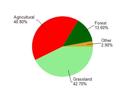
Grant River is located in the Upper Grant River watershed which is 106.09 mi². Land use in the watershed is primarily grassland (42.70%), agricultural (40.80%) and a mix of forest (13.60%) and other uses (2.90%). This watershed has 260.94 stream miles, 7.24 lake acres and 6.79 wetland acres.
Nonpoint Source Characteristics
This watershed is ranked High for runoff impacts on streams, Not Available for runoff impacts on lakes and High for runoff impacts on groundwater and therefore has an overall rank of High. This value can be used in ranking the watershed or individual waterbodies for grant funding under state and county programs.However, all waters are affected by diffuse pollutant sources regardless of initial water quality. Applications for specific runoff projects under state or county grant programs may be pursued. For more information, go to surface water program grants.