Pierce
Yes
No
No
Fish and Aquatic Life
Overview
The Rush River begins in southern St. Croix County as a warm water forage fishery. As more
springs add cold water to the river, the lower three miles in St. Croix County are designated as Class
III trout. More springs exist at the border with Pierce County, which helps with carryover of
stocked trout. Since little habitat exists for successful natural reproduction, the Pierce County
section is considered Class II, except for the last four miles, which maintains a warm water sport
fishery. The Class II portion is designated an exceptional resource water (ERW) in NR 102. The
ERW designation requires that all new point sources must have discharge limits as stringent as the
water quality found in the Rush River, unless the discharge is needed to correct an environmental
problem. The Rush River is normally a dry run above the city of Baldwin except during storm
runoff. The storm runoff tends to be severe and highly turbid due to cropping of clay soils.
South of Baldwin sinkholes in the riverbed cause the flow to disappear underground. This direct
connection between ground and surface water is potentially very hazardous to groundwater quality.
(See discussion in Groundwater Report.)
While the river most likely always floods during storms, continued farming has decreased
infiltration, which reduces the amount of groundwater entering the Rush River from its numerous
springs. To improve the Class II portion of the Rush River, the stream's average temperature needs
to be decreased. This could be accomplished by increasing the amount of groundwater discharging to
the river. To improve groundwater discharge, best management practices for control of nonpoint
sources of pollution would allow more water to sink into the ground and replenish groundwater
supplies. These measures would also reduce sedimentation and turbidity in the stream, thus
improving in-stream habitat. Additionally, to improve the success of this stream as a Class II
fishery, in-stream habitat that provides cover and protection to fish during flooding is necessary.
The Rush River is an excellent Class II trout stream, with fast growth rates, but severe and
frequent flooding and loss of spring flow threaten this resource. Angler use is considered high. A
stream survey conducted in the St. Croix County portion of the Rush River near Centerville would
document the numbers and species of fish and aquatic insects inhabiting that stretch of river (Engel 1993)
Date 1996
Author Aquatic Biologist
Historical Description
Rush River -T28N, R17W, Sec. 34 to T28N, R17W, Sec. 35, Surface Acres = 1.7, Miles = 1.4, Gradient = 10 feet per mile.
Flows south into Pierce County and the St. Croix River. Although its water course has spring origins near Baldwin, it becomes an intermittent stream before reaching Rush River Township and remains so until a mile north of Centerville.
Its fish population consists of an abundance of white suckers, with a few pumpkin- seeds, green sunfish, carp and a variety of forage minnow species. It is subject to very extreme seasonal flooding. Access may be had from several road bridges.
From: Sather, LaVerne M. and Threinen, C.W., 1961. Lake and Stream Classification Project. Surface Water Resources of St. Croix County, Wisconsin Department of Natural Resources, Madison, WI.
Date 1961
Author Surface Water Inventory Of Wisconsin
General Condition
The Rush River was assessed during the 2018 listing cycle; new biological (macroinvertebrate Index of Biotic Integrity (IBI) scores) sample data were clearly below the 2018 WisCALM listing thresholds for the Fish and Aquatic Life use. This water was meeting this designated use and was not considered impaired.
Date 2017
Author Ashley Beranek
Condition
Wisconsin has over 84,000 miles of streams, 15,000 lakes and milllions of acres of wetlands. Assessing the condition of this vast amount of water is challenging. The state's water monitoring program uses a media-based, cross-program approach to analyze water condition. An updated monitoring strategy (2015-2020) is now available. Compliance with Clean Water Act fishable, swimmable standards are located in the Executive Summary of Water Condition in 2018. See also the 'monitoring and projects' tab.
Reports
Management Goals
Wisconsin's Water Quality Standards provide qualitative and quantitative goals for waters that are protective of Fishable, Swimmable conditions [Learn more]. Waters that do not meet water quality standards are considered impaired and restoration actions are planned and carried out until the water is once again fishable and swimmable
Management goals can include creation or implementation of a Total Maximum Daily Load analysis, a Nine Key Element Plan, or other restoration work, education and outreach and more. If specific recommendations exist for this water, they will be displayed below online.
Monitoring
Monitoring the condition of a river, stream, or lake includes gathering physical, chemical, biological, and habitat data. Comprehensive studies often gather all these parameters in great detail, while lighter assessment events will involve sampling physical, chemical and biological data such as macroinvertebrates. Aquatic macroinvertebrates and fish communities integrate watershed or catchment condition, providing great insight into overall ecosystem health. Chemical and habitat parameters tell researchers more about human induced problems including contaminated runoff, point source dischargers, or habitat issues that foster or limit the potential of aquatic communities to thrive in a given area. Wisconsin's Water Monitoring Strategy was recenty updated.
Grants and Management Projects
Monitoring Projects
| WBIC | Official Waterbody Name | Station ID | Station Name | Earliest Fieldwork Date | Latest Fieldwork Date | View Station | View Data |
|---|
| 2440300 | Rush River | 10008901 | 3 Rush River Cth A | | | Map | Data |
| 2440300 | Rush River | 10055592 | Rush River Spring | 8/11/2021 | 8/11/2021 | Map | Data |
| 2440300 | Rush River | 10039668 | Rush River E of CTH A and 3 mi N of STH 35 | 5/16/2011 | 9/2/2013 | Map | Data |
| 2440300 | Rush River | 10008903 | 4 - Rush River - 385th St. | 10/10/2007 | 9/29/2023 | Map | Data |
| 2440300 | Rush River | 10008899 | 2-Rush River-385th St Maiden Rock | 2/20/2007 | 2/20/2007 | Map | Data |
| 2440300 | Rush River | 483081 | Rush River at Sth 35 | 9/28/2000 | 9/28/2000 | Map | Data |
| 2440300 | Rush River | 10008897 | Rush River at STH 35 [1] | | | Map | Data |
| 2440300 | Rush River | 483080 | Rush River - 385th St. | 9/28/2000 | 5/4/2022 | Map | Data |
| 2440300 | Rush River | 10044491 | Rush River - NE1/4 NW1/4 S33 near South line | | | Map | Data |
| 2440300 | Rush River | 10055597 | Rush River Spring | 7/8/2021 | 7/8/2021 | Map | Data |
|
Watershed Characteristics
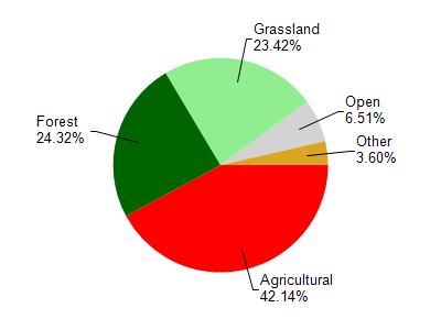
Rush River is located in the Rush River watershed which is 289.57 mi². Land use in the watershed is primarily agricultural (42.10%), forest (24.30%) and a mix of grassland (23.40%) and other uses (10.10%). This watershed has 599.35 stream miles, 191.91 lake acres and 2,372.17 wetland acres.
Nonpoint Source Characteristics
This watershed is ranked Medium for runoff impacts on streams, Not Ranked for runoff impacts on lakes and High for runoff impacts on groundwater and therefore has an overall rank of High. This value can be used in ranking the watershed or individual waterbodies for grant funding under state and county programs.However, all waters are affected by diffuse pollutant sources regardless of initial water quality. Applications for specific runoff projects under state or county grant programs may be pursued. For more information, go to surface water program grants.