Pierce
Yes
No
No
Fish and Aquatic Life
Overview
Above lake Eau Galle in Dunn County (class 2), all of the stream in Pierce County (class 2); from Lake George to CTH N in St. Croix County (class 3).
Date 2002
Author Aquatic Biologist
Historical Description
From Dunn county line to Highway 72/CTH G west of Elmwood (class 3); from Highway 72/CTH G to Lake George (class 2); from Lake George to CTH N in St. Croix County (class 3).
Date 1980
Author Surface Water Inventory Of Wisconsin
Historical Description
Eau Galle River -T2 N, R16W, Sec. 24 to T28N, R15W, Sec. 31, Surface Acres = 5.8, Miles = 5.8, Gradient = 22 feet per mile. Flows south into Pierce County and the Chippewa River. Managed for trout, this stream has brown and rainbow trout present in it along with a few warm water fish species. Seasonal high water levels are a problem to management. A four acre wetland bordering the river provides additional habitat for muskrat, beaver and nesting wood ducks. There is no private development other than pastured farmland along the stream and public frontage on it consists of one road- bridge access.
From: Sather, LaVerne M. and Threinen, C.W., 1961. Lake and Stream Classification Project. Surface Water Resources of St. Croix County, Wisconsin Department of Natural Resources, Madison, WI.
Date 1961
Author Surface Water Inventory Of Wisconsin
General Condition
On 1980 Trout Streams list (class 3), upgraded to class 2 in 2002. Bug IBI, 2.5-4.9, Fair 03/14/2012 MIBI Median = 4.78117; Impaired = N; Dates: 1/1/2002 - 3/13/2012 173212 Eau Galle River at Cth D
Date 2014
Author Lisa Helmuth
General Condition
The Eau Galle River is a popular place to fish for trout. The growth rate of trout in this waterbody is above average, however the trout densities are low. Factors limiting the potential of the Eau Galle River are lack of habitat (pools), flooding, and transport of bedload sand which smothers instream habitat. The 4.5 miles of Class 111 trout and additional 1.5 miles of warm water fora~e u fishery above Eau Galle Lake at Spring Valley have the potential to attain a classification of Class II trout water if the effects of polluted runoff were to be controlled.
The 10.1-mile stretch of Class 11 and 111 trout water below Spring Valley is threatened by turbidity, natural erosion, and streambank grazing. The 1.8 mile section of Class III trout stream below Spring Valley could improve to Class II trout if the effects of polluted runoff are abated (Engel, 1993). The levels of ammonia coming from the Spring Valley wastewater treatment plant has the potential to affect the fishery during low flows. WDNR is revising its standards and policies for ammonia and will apply any necessary limits to the Spring Valley WPDES permit (LaLiberte).
Date 1996
Author Paul Laliberte
Impaired Waters
Eau Galle River was recently evaluated during the ten-year period of 2009 through 2018 for results that were reported to the USEPA for the 2020 Clean Water Act condition report. The waterbody is considered impaired, or in poor condition for designated uses which include the quality of fish and aquatic life, recreational use, and public health and welfare (fish consumption and related). Pollutants or problems encountered during sampling (impairments) are determined based on water quality standards outlined in Wisconsin 2020 Consolidated Assessment and Listing Methodology (WisCALM). Assessment results show water conditions that are potentially harmful for Aquatic Life use due to values for total phosphorus that fall into the range expected for an aquatic community in poor health, therefore this water is listed as impaired.
Eau Galle River (mile 0-8.83): This segment has been listed as impaired since 2014 for total phosphorus.
Eau Galle River (mile 11.24-24.06): Assessment results during the 2020 listing cycle show impairment by total phosphorus. Phosphorus levels were too high for healthy aquatic communities like plants, bugs, and fish based on 2020 WisCALM standards. Available biological data showed good condition. Based on the most updated information, this portion of the river was proposed for the impaired waters list in 2020.
Eau Galle River (mile 24.05-32.55): There is not enough information about this segment to properly assess condition.
Eau Galle River (mile 32.55-33.79): This segment has been listed as impaired since 1998 for total phosphorus.
Eau Galle River (mile 33.79-39.24): This segment has been listed as impaired since 1998 for total suspended solids.
Eau Galle River (mile 39.24-40.74): There is not enough information about this segment to properly assess condition; however the information that has been assessed leads to the suspicion that Aquatic Life use is in poor condition.
Date 2019
Author Ashley Beranek
Impaired Waters
The 2018 assessments of the Eau Galle River (miles 0-8.83) showed continued impairment by phosphorus; new total phosphorus sample data exceeded the 2018 WisCALM listing criteria for the Fish and Aquatic Life use, however, available biological data did not indicate impairment (i.e. no macroinvertebrate or fish Index of Biotic Integrity (IBI) scored in the "poor" condition category). Based on the most updated information, no change in the existing impaired waters listing was needed.
Date 2017
Author Ashley Beranek
Condition
Wisconsin has over 84,000 miles of streams, 15,000 lakes and milllions of acres of wetlands. Assessing the condition of this vast amount of water is challenging. The state's water monitoring program uses a media-based, cross-program approach to analyze water condition. An updated monitoring strategy (2015-2020) is now available. Compliance with Clean Water Act fishable, swimmable standards are located in the Executive Summary of Water Condition in 2018. See also the 'monitoring and projects' tab.
Reports
Recommendations
Monitor Water Quality or Sediment
2012 was a drought year and last two years were generally wetter than normal...I'd prefer getting samples during a normal year. AU: 15609; Station ID: 10009391
Monitor Water Quality or Sediment
Category 2. 2018 TP Results: May Exceed. Station: 483019. AU: 18771.
Monitor Water Quality or Sediment
Category 3. Limited sampling show concentrations are below the standard. I'd prefer getting samples during a normal year and assess other assessment units at the same time to put the pieces together. 2018 TP Results: May Exceed. Station: 10009391. AU: 15609.
Monitor Aquatic Biology
Conduct biological (mIBI or fIBI) monitoring on Eau Galle River, WBIC: 2055000, AU:888381
Restore Wetlands
Restore Wetlands
Restore Wetlands
Restore Wetlands
Water Quality Planning
The Bear Creek Watershed covers 76.5 square miles in Buffalo and Pepin counties. Bear, Little Bear, and Spring creeks are the three primary sub-watersheds within the Bear Creek Watershed. The watershed drains rolling agricultural and wooded areas with many of the tributaries originating in steep coulees. The watershed also drains one urban area, the City of Durand. All streams within the Bear Creek Watershed drain the eastern slope of the Chippewa River Valley. The Bear Creek Watershed contains typical steep topography characteristic of the driftless or un-glaciated area of the state. Because the most productive and level land is on the valley floor, most farming takes place immediately adjacent to streams. Former prairie and a portion of the forested lands have been converted to agricultural uses. The quality of trout streams in this watershed have improved or degraded as agricultural uses have diminished or increased. Earlier editions of the Lower Chippewa River Water Quality Management Plan indicated the Nelson wastewater treatment plant and Nelson Cheese actory discharged to the Lower Chippewa Basin. Due to a basin oundary change, both are in the Buffalo- Trempealeau River Basin. The majority of the wetlands in the watershed are adjacent to the Chippewa and Mississippi Rivers.
Management Goals
Wisconsin's Water Quality Standards provide qualitative and quantitative goals for waters that are protective of Fishable, Swimmable conditions [Learn more]. Waters that do not meet water quality standards are considered impaired and restoration actions are planned and carried out until the water is once again fishable and swimmable
Management goals can include creation or implementation of a Total Maximum Daily Load analysis, a Nine Key Element Plan, or other restoration work, education and outreach and more. If specific recommendations exist for this water, they will be displayed below online.
Monitoring
Monitoring the condition of a river, stream, or lake includes gathering physical, chemical, biological, and habitat data. Comprehensive studies often gather all these parameters in great detail, while lighter assessment events will involve sampling physical, chemical and biological data such as macroinvertebrates. Aquatic macroinvertebrates and fish communities integrate watershed or catchment condition, providing great insight into overall ecosystem health. Chemical and habitat parameters tell researchers more about human induced problems including contaminated runoff, point source dischargers, or habitat issues that foster or limit the potential of aquatic communities to thrive in a given area. Wisconsin's Water Monitoring Strategy was recenty updated.
Grants and Management Projects
Monitoring Projects
| WBIC | Official Waterbody Name | Station ID | Station Name | Earliest Fieldwork Date | Latest Fieldwork Date | View Station | View Data |
|---|
| 2055000 | Eau Galle River | 10012177 | Eau Galle 18matConfluence W/Mines Creek | 10/15/2012 | 11/6/2017 | Map | Data |
| 2055000 | Eau Galle River | 10010897 | Eau Galle River - 16 (30 Ft. Upstream From 170 St.) | | | Map | Data |
| 2055000 | Eau Galle River | 10009688 | Eau Galle 13- Mowed Path Off Sth 128 By Elmwood | 6/5/2004 | 6/5/2004 | Map | Data |
| 2055000 | Eau Galle River | 483018 | Eau Galle River - Twn R Bridge R.M30.3 | | | Map | Data |
| 2055000 | Eau Galle River | 10009391 | Eau Galle 18b- Hwy 29 (Downstream) | 7/14/2004 | 10/23/2023 | Map | Data |
| 2055000 | Eau Galle River | 10009687 | Eau Galle Station 12 Upstream Of Sth 72 | | | Map | Data |
| 2055000 | Eau Galle River | 10009392 | Eau Galle 18a - Hwy 29 (Upstream) | | | Map | Data |
| 2055000 | Eau Galle River | 10012194 | Below George Lake Dam - Eau Galle River | 6/4/2004 | 6/4/2004 | Map | Data |
| 2055000 | Eau Galle River | 10007602 | Eau Galle River - Below Lake George Dam | | | Map | Data |
| 2055000 | Eau Galle River | 10040241 | Eau Galle River at Handy Andy Park Spring Valley on HWY 29 | 6/23/2012 | 10/8/2017 | Map | Data |
| 2055000 | Eau Galle River | 10044422 | Eau Galle River - midpoint of SE1/4 of S8 T27N R15W | | | Map | Data |
| 2055000 | Eau Galle River | 10009696 | Eau Galle Station 17 Cth B Below Spring Valley | | | Map | Data |
| 2055000 | Eau Galle River | 10044420 | Eau Galle River - NE1/4 SW1/4 S22 T27N R15W | | | Map | Data |
| 2055000 | Eau Galle River | 10044419 | Eau Galle River - near Hwy 128 in NE SE S27 | | | Map | Data |
| 2055000 | Eau Galle River | 483016 | Eau Galle River - Below Sth 29 R.Mi-30.8 | 8/12/1988 | 10/8/2002 | Map | Data |
| 2055000 | Eau Galle River | 10044421 | Eau Galle River - below the old gravel quarry south of the town road bridge | | | Map | Data |
| 2055000 | Eau Galle River | 10009691 | Eau Galle River at 770th Ave Bridge | | | Map | Data |
| 2055000 | Eau Galle River | 10009389 | Eau Galle 14 - Jct Of Cth B And Hwy 128 | | | Map | Data |
| 2055000 | Eau Galle River | 10009390 | Eau Galle 16 - 170th | 7/15/2022 | 7/15/2022 | Map | Data |
| 2055000 | Eau Galle River | 10043364 | Eau Galle River at mowed path off STH 128 by Elmwood | | | Map | Data |
| 2055000 | Eau Galle River | 483067 | Eau Galle River at Eau Galle Rd Spring Valley WI | 1/5/1995 | 12/7/1995 | Map | Data |
|
Watershed Characteristics
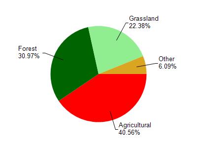
Eau Galle River is located in the Eau Galle River watershed which is 267.88 mi². Land use in the watershed is primarily agricultural (40.60%), forest (31%) and a mix of grassland (22.40%) and other uses (6.10%). This watershed has 519.34 stream miles, 251.50 lake acres and 3,943.12 wetland acres.
Nonpoint Source Characteristics
This watershed is ranked High for runoff impacts on streams, Not Ranked for runoff impacts on lakes and High for runoff impacts on groundwater and therefore has an overall rank of High. This value can be used in ranking the watershed or individual waterbodies for grant funding under state and county programs.However, all waters are affected by diffuse pollutant sources regardless of initial water quality. Applications for specific runoff projects under state or county grant programs may be pursued. For more information, go to surface water program grants.