Dane
Yes
No
No
Fish and Aquatic Life
Overview
The West Branch of the Sugar River rises near the southwest limits of the Village of Mount Horeb and land use is mostly agricultural. The Mount Horeb wastewater treatment plan is the only permitted facility discharging effluent to headwaters of the West Branch Sugar River. The river, from Mt. Vernon Creek down to its confluence with the Sugar River, is considered to be trout water. Upstream from this stretch, the river is currently listed as a warm water sport fishery. The headwaters of the river are listed as a limited forage fishery. The river has been listed as “impaired” on the EPA’s list of impaired waters due to nonpoint source and point source impacts.
In-stream habitat surveys from the late 1990’s indicated that the habitat suffers from environmental degradation. In response, during the summer of 2000, 2001 and 2002, stream and habitat restoration projects funded by the state’s Targeted Runoff Management program and Trout Unlimited were implemented to improve habitat along the river. Monitoring of fish populations in sections of stream completed in 2000 and 2001 have shown an increase in the number of brown trout (Sorge,pers.comm). These habitat restoration projects will continue through 2003. Once this project is completed over 18 miles of stream will have been rehabilitated. Although the upper two miles of the West Branch are listed as a limited forage fishery, monitoring of the stream at Barton Road showed the presence of intolerant cold water species such as mottled sculpin and brook trout (Amrhein, pers. obs). Temperature monitoring is being conducted to determine if this portion is able to sustain a cold water fishery. Because of the extensive work done to rehabilitate the steam, as well as the indirect benefit of increase baseflow due to changes in land use in the region, the department will have to pursue reclassifying the upper portions of the stream.
Date 2002
Author Aquatic Biologist
Historical Description
Sugar River West Branch -T5N, R8E, Sec. 28, Surface acres = 30, Length = 18 miles, Stream order = III, Gradient = 7.5 ft/mile, Base discharge = 8.1 cfs.
The Sugar River West Branch originates south of Mount Horeb, and flows southeast to meet the Sugar River just upstream of Bellevllle. It drains 66.5 square miles which is mostly pasture land with the remainder in upland hardwoods, marsh, and cropland. Above Mount Vernon Creek, the West Branch has a moderate gradient and low base flow. Below this point, the creek has mostly a very low gradient and meanders through a wide flood plain (Dane Cty. Reg. Plann. Comm. 1979a). Flow is augmented by the input from several spring-fed tributaries that support trout fisheries.
Channel alterations have been made in the lower portions of the West Branch for the purpose of draining agricultural lands. Stream bank erosion, in-stream watering, and overgrazing by livestock are very significant problems for this stream (Dane Cty. Reg. Plann. Comm. 1979a). Many portions of the stream are heavily silted and fertility is high. Mount Horeb discharges treated sewage effluent to the headwaters of the West Branch of the Sugar River. Effluent standards for this plant have recently been upgraded and any pollution from this source is less important than nonpolnt sources (Dane Cty. Reg. Plann. Comm. 1979a).
The stream from the mouth of the Primrose Branch (Sec. 14, T5N, R7E) to Hwy. PB is classified as a Class II trout stream. Stream habitat development has been conducted by the Dane County Conservation League and Madison School Program in cooperation with the DNR. There is limited spawning of brown trout in the stream, and both brown and rainbow trout have been stocked. The remaining portions of the West Branch of the Sugar River support e diverse warm water fishery. There is no public ownership of lands along the stream but the Dane County Conservation League has leases with several landowners to better protect end manage the stream. Access is avellable at 7 road crossings.
Fish species: brook lamprey, rainbow, brown, and brook trout, central mudminnow, northern pike, minnow (unsp.), stoneroller (unsp.), central stoneroller, redside dace, common carp, brassy minnow, golden, common, and sand shiner, bluntnose and fathead minnow, creek chub, buffalo (unsp.), river carpsucker, white sucker, golden redhorse, black end yellow bullhead, brook stickleback, green sunfish, pumpkinseed, largemouth bass, black crepple, Johnny and blackslde darter, walleye, sculpin (unsp.), and mottled sculpin.
From: Day, Elizabeth A.; Grzebieniak, Gayle P.; Osterby, Kurt M.; and Brynildson, Clifford L., 1985. Lake and Stream Classification Project. Surface Water Resources of Dane County, Wisconsin Department of Natural Resources, Madison, WI.
Date 1985
Author Surface Water Inventory Of Wisconsin
Impaired Waters
The 2018 assessments of the West Branch Sugar River (from Highway 92 to CTH JG) showed impairment by phosphorus; new total phosphorus sample data exceeded the 2018 WisCALM listing criteria for the Fish and Aquatic Life use. However, available biological data did not indicate impairment. Existing macroinvertebrate and new fish sample data were assessed, but no macroinvertebrate or fish Index of Biotic Integrity (IBI) scored in the "poor" condition category. New temperature sample data were assessed and found to exceeded the 2018 WisCALM listing criteria for the Fish and Aquatic Life use. Based on the most updated information, this water was proposed for the impaired waters list.
Date 2017
Author Ashley Beranek
Impaired Waters
West Branch Sugar River (886100) from its mouth to Highway 92 was placed on the impaired waters list for total phosphorus in 2012. The 2016 assessments showed continued impairment by phosphorus; total phosphorus sample data exceed 2016 WisCALM listing criteria for the Fish and Aquatic Life use, however, no biological data (i.e. no macroinvertebrate or fish Index of Biotic Integrity (IBI) scores) were available to assess biological impairment. Based on the most updated information, no change in existing impaired waters listing is needed.
Date 2015
Author Aaron Larson
Condition
Wisconsin has over 84,000 miles of streams, 15,000 lakes and milllions of acres of wetlands. Assessing the condition of this vast amount of water is challenging. The state's water monitoring program uses a media-based, cross-program approach to analyze water condition. An updated monitoring strategy (2015-2020) is now available. Compliance with Clean Water Act fishable, swimmable standards are located in the Executive Summary of Water Condition in 2018. See also the 'monitoring and projects' tab.
Reports
Recommendations
Citizen-Based Stream Monitoring
Collect chemical, physical, and/or biological water quality data to assess the current overall stream health. The data can inform management decisions and may be used to identify impaired waters for biennial lists.
Citizen-Based Stream Monitoring
Collect chemical, physical, and/or biological water quality data to assess the current overall stream health. The data can inform management decisions and may be used to identify impaired waters for biennial lists.
Citizen-Based Stream Monitoring
Collect chemical, physical, and/or biological water quality data to assess the current overall stream health. The data can inform management decisions and may be used to identify impaired waters for biennial lists.
Restore Wetlands
Restore Wetlands
Management Goals
Wisconsin's Water Quality Standards provide qualitative and quantitative goals for waters that are protective of Fishable, Swimmable conditions [Learn more]. Waters that do not meet water quality standards are considered impaired and restoration actions are planned and carried out until the water is once again fishable and swimmable
Management goals can include creation or implementation of a Total Maximum Daily Load analysis, a Nine Key Element Plan, or other restoration work, education and outreach and more. If specific recommendations exist for this water, they will be displayed below online.
Monitoring
Monitoring the condition of a river, stream, or lake includes gathering physical, chemical, biological, and habitat data. Comprehensive studies often gather all these parameters in great detail, while lighter assessment events will involve sampling physical, chemical and biological data such as macroinvertebrates. Aquatic macroinvertebrates and fish communities integrate watershed or catchment condition, providing great insight into overall ecosystem health. Chemical and habitat parameters tell researchers more about human induced problems including contaminated runoff, point source dischargers, or habitat issues that foster or limit the potential of aquatic communities to thrive in a given area. Wisconsin's Water Monitoring Strategy was recenty updated.
Grants and Management Projects
Monitoring Projects
| WBIC | Official Waterbody Name | Station ID | Station Name | Earliest Fieldwork Date | Latest Fieldwork Date | View Station | View Data |
|---|
| 886100 | West Branch Sugar River | 133217 | Sugar River West Branch at Barton Road | | | Map | Data |
| 886100 | West Branch Sugar River | 133216 | Sugar River West Branch - Docken Road | 5/9/1975 | 10/28/2018 | Map | Data |
| 886100 | West Branch Sugar River | 10009365 | West Branch Sugar River At Cth Jg (Segment #14) | 5/1/1997 | 8/2/2017 | Map | Data |
| 886100 | West Branch Sugar River | 10009700 | West Branch Sugar At Barton Rd (Segment #15) | 5/9/1975 | 10/28/2017 | Map | Data |
| 886100 | West Branch Sugar River | 133557 | West Branch Sugar River at Cth Jg | 9/30/1987 | 8/6/2025 | Map | Data |
|
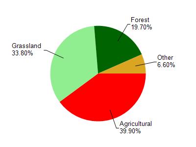
Watershed Characteristics
West Branch Sugar River is located in the West Branch Sugar River - Mt. Vernon Cre watershed which is 66.74 mi². Land use in the watershed is primarily agricultural (39.90%), grassland (33.80%) and a mix of forest (19.70%) and other uses (6.60%). This watershed has 156.64 stream miles, 9.41 lake acres and 1,131.91 wetland acres.
Nonpoint Source Characteristics
This watershed is ranked High for runoff impacts on streams, Not Ranked for runoff impacts on lakes and High for runoff impacts on groundwater and therefore has an overall rank of High. This value can be used in ranking the watershed or individual waterbodies for grant funding under state and county programs.However, all waters are affected by diffuse pollutant sources regardless of initial water quality. Applications for specific runoff projects under state or county grant programs may be pursued. For more information, go to surface water program grants.