Dane
Yes
Yes
No
Fish and Aquatic Life
Overview
Mount Vernon Creek is classified as a trout stream for its entire length. The creek above section 2 in T5N R7E are classified as an outstanding resource water (ORW) while below, the creek is an exceptional resource water (ERW).
Sources of polluted runoff threaten parts of this stream, but the total extent of the threat has not been evaluated. Increased nitrate concentrations have been documented, and are apparently directly related to agricultural changes in the watershed (Mason et.al., 1990). Intensive efforts at soil consevation and streambank protection programs in the Mt. Vernon Creek watershed have demonstrated that substantial (up to 50%) reductions in erosion and impacts on stream habitat can be achieved with aggressive nonpoint source control programs. (Citation - none listed should we just put down DCRPC?)
Date 2002
Author Aquatic Biologist
Historical Description
Mount Vernon Creek -T5N, R7E, Sec. 13, Surface acres = 10, Length = 7 miles, Stream order = II, Gradient = 18.5 ft/mile,
Base discharge = 19.7 cfs.
This medium-sized tributary of the West Branch of the Sugar River originates in the moraines of southwestern Dane County at the junction of Deer Creek and Fryes Feeder. The former Helland Spring, now owned by the state and located approximately 1 mile above the Village of Mount Vernon, contributes substantially to the flow. The watershed is comprIsed mostly of cropland, pasture, and upland hardwoods. The bottom substrate consists of gravel and rubble in the upper sections grading to clay, hardpan and silt in the lower sections. Water quality is good. Aquatic vegetation is plentiful in the upper sections including watercress, speedwell, water buttercup, flat-leaved pondweed, and crowfoot. Parts of the stream near the mouth were dredged in the 1940's, and a dam above Hwy. G was abandoned in 1948.
The trout fishery in Mount Vernon Creek has been extensively researched, developed, and managed for the last thirty years. An intensive habitat improvement program initiated in 1964 included placement of in-stream cover, extensive fencing, and installation of spawning beds. The state has acquired 5-1/2 miles of stream frontage and 389 acres of surrounding land. Mount Vernon Creek is now one of the best trout streams in the area and stockng is not necessary. A population survey in autumn of 1980 estimated over 10,000 native brown trout present, including nearly 3,500 yearlings and over 2,100 adult fish. Trout are more numerous in the upper sections but are larger in the lower sections. A 12-pound fish was removed from the stream in 1972 and each year several fish over 20 inches long are taken by anglers. Fishing pressure is heavy and fly fishermen, spln-casters, and bait fishermen all enjoy success. Access is easy, as nearly all stream frontage is publicly owned, and is also available at four road crossings. State-owned lowlands and hardwood uplands provide habitat for deer, rabbits, squirrels, furbearers, ducks, pheasants, and ruffed grouse. Considerable hunting and trapping occurs for these species each year. Fish species: brook lamprey, rainbow, brown, and brook trout, central mudminnow, common shiner, and fathead minnow, creek chub, white sucker, and mottled sculpln.
From: Day, Elizabeth A.; Grzebieniak, Gayle P.; Osterby, Kurt M.; and Brynildson, Clifford L., 1985. Lake and Stream Classification Project. Surface Water Resources of Dane County. Wisconsin Department of Natural Resources, Madison, WI
Date 1985
Author Surface Water Inventory Of Wisconsin
General Condition
Mt. Vernon Creek (miles 0-3.47) was assessed during the 2018 listing cycle; new biological (fish Index of Biotic Integrity (IBI) scores) sample data were clearly below the 2018 WisCALM listing thresholds for the Fish and Aquatic Life use. This water was meeting this designated use and was not considered impaired.
Date 2017
Author Ashley Beranek
General Condition
Mt. Vernon Creek (miles 3.47-5.9) was assessed during the 2018 listing cycle; new biological (macroinvertebrate and fish Index of Biotic Integrity (IBI) scores) and temperature sample data were clearly below the 2018 WisCALM listing thresholds for the Fish and Aquatic Life use. This water was meeting this designated use and was not considered impaired.
Date 2017
Author Ashley Beranek
Condition
Wisconsin has over 84,000 miles of streams, 15,000 lakes and milllions of acres of wetlands. Assessing the condition of this vast amount of water is challenging. The state's water monitoring program uses a media-based, cross-program approach to analyze water condition. An updated monitoring strategy (2015-2020) is now available. Compliance with Clean Water Act fishable, swimmable standards are located in the Executive Summary of Water Condition in 2018. See also the 'monitoring and projects' tab.
Reports
Recommendations
Citizen-Based Stream Monitoring
Collect chemical, physical, and/or biological water quality data to assess the current overall stream health. The data can inform management decisions and may be used to identify impaired waters for biennial lists.
Management Goals
Wisconsin's Water Quality Standards provide qualitative and quantitative goals for waters that are protective of Fishable, Swimmable conditions [Learn more]. Waters that do not meet water quality standards are considered impaired and restoration actions are planned and carried out until the water is once again fishable and swimmable
Management goals can include creation or implementation of a Total Maximum Daily Load analysis, a Nine Key Element Plan, or other restoration work, education and outreach and more. If specific recommendations exist for this water, they will be displayed below online.
Monitoring
Monitoring the condition of a river, stream, or lake includes gathering physical, chemical, biological, and habitat data. Comprehensive studies often gather all these parameters in great detail, while lighter assessment events will involve sampling physical, chemical and biological data such as macroinvertebrates. Aquatic macroinvertebrates and fish communities integrate watershed or catchment condition, providing great insight into overall ecosystem health. Chemical and habitat parameters tell researchers more about human induced problems including contaminated runoff, point source dischargers, or habitat issues that foster or limit the potential of aquatic communities to thrive in a given area. Wisconsin's Water Monitoring Strategy was recenty updated.
Grants and Management Projects
Monitoring Projects
| WBIC | Official Waterbody Name | Station ID | Station Name | Earliest Fieldwork Date | Latest Fieldwork Date | View Station | View Data |
|---|
| 886600 | Mt Vernon Creek | 10030373 | Mt Vernon Creek 853m DS of Hwy U Bridge | | | Map | Data |
| 886600 | Mt Vernon Creek | 10030372 | Mt Vernon Creek 1155m DS of Hwy U Bridge | | | Map | Data |
| 886600 | Mt Vernon Creek | 10030366 | Mt Vernon Creek at South lot access on Hwy 92 | | | Map | Data |
| 886600 | Mt Vernon Creek | 10030374 | Mt Vernon Creek 509m DS of Hwy U Bridge | | | Map | Data |
| 886600 | Mt Vernon Creek | 10009461 | Mt Vernon Upstream From 92 | 10/26/2002 | 7/10/2024 | Map | Data |
| 886600 | Mt Vernon Creek | 10013349 | Mt Vernon Creek 1-2 (S. Of Cth A) | | | Map | Data |
| 886600 | Mt Vernon Creek | 10044092 | Mt Vernon Creek at 1st farm lane north of STH 92 crossing | 1/1/2015 | 1/1/2015 | Map | Data |
| 886600 | Mt Vernon Creek | 10012637 | Mt. Vernon Creek At Cth A | 10/13/1989 | 6/21/2024 | Map | Data |
| 886600 | Mt Vernon Creek | 10030367 | Mt Vernon Creek at North Lot access on Hwy 92 | 1/1/2015 | 6/21/2024 | Map | Data |
|
Watershed Characteristics
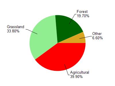
Mt Vernon Creek is located in the West Branch Sugar River - Mt. Vernon Cre watershed which is 66.74 mi². Land use in the watershed is primarily agricultural (39.90%), grassland (33.80%) and a mix of forest (19.70%) and other uses (6.60%). This watershed has 156.64 stream miles, 9.41 lake acres and 1,131.91 wetland acres.
Nonpoint Source Characteristics
This watershed is ranked High for runoff impacts on streams, Not Ranked for runoff impacts on lakes and High for runoff impacts on groundwater and therefore has an overall rank of High. This value can be used in ranking the watershed or individual waterbodies for grant funding under state and county programs.However, all waters are affected by diffuse pollutant sources regardless of initial water quality. Applications for specific runoff projects under state or county grant programs may be pursued. For more information, go to surface water program grants.