Ozaukee
No
No
No
Fish and Aquatic Life
Overview
The Pigeon Creek subwateshed, located in southwest Ozaukee County, is drained by Pigeon Creek, the principal perennial stream, one other unnamed perennial stream, as well as eight small intermittent streams.
The 6.8 mile-length of Pigeon Creek, located in southwest Ozaukee County (T9N R21E, Sec.23, SW of NW quarter), drains 11.5 square miles prior to its confluence with the Milwaukee River in the village of Thiensville. The stream originates as a series of small intermittent tributaries, small wetland parcels, and groundwater seeps. Cobble and gravel-size materials are the dominant and preferred substrate along most of Pigeon Creek. Embeddedness as a measure of deposition averaged between 5 percent to 50 percent over the four reaches surveyed. Pool deposits often exceed 1.0 foot in depth and embeddedness is more extensive along the upper reaches of the stream where agricultural land uses dominate.
Habitat quality and water quality in Pigeon Creek are considered "fair" to "poor". As a result, the stream is not meeting its full potential uses. Observed or potential problems limiting these uses include loss of fish and invertebrate habitat, a fish migration barrier, and potential low dissolved oxygen levels. Sources of these problems include channelization, sedimentation, livestock pasturing, low flow, urban runoff, excessive algae growth, and a dam. Potential exists for bacterial contamination of Pigeon Creek by animal waste runoff from livestock pasturing and urban land use. Unnamed perennial stream A conveys runoff from urban land use. This stream probably contains excessive amounts of nutrients as indicated by extensive filamentous algae growth. Habitat and water quality are impacted by low flow, sedimentation, channelization, and/or draining of wetlands. Low-flow characteristics are assumed to be derived from natural and human processes.
Date 1992
Author Aquatic Biologist
Historical Description
Pigeon Creek, and all other streams in this subwatershed, are classified as supporting "partialbody
contact" forms of recreational use. Factors primarily limiting this use include low flow and
shallow depth.
Fisheries - Pigeon Creek is a small perennial stream that supports a very diverse fish
community, a condition which reflects the considerable habitat modification which has occurred.
Suckers, stonerollers, darters and dace are the typical inhabitants of the less-disturbed stream
reaches while largemouth bass, bullhead and various sunfsh are more common in the lake-like
environments of the interconnected ponds. Lower portions of this stream are also used by rock
bass, smallmouth bass and northern pike. However, the small populations of these species do
not sustain a significant sport fishery. Impacts from increasing residential development, existing
ditching and draining for agriculture, and eutrophication of tributary ponds are the most
immediate factors limiting the fisheries potential of this drainage. The small size of Pigeon
Creek may indicate that this stream's greatest potential is providing important spawning and
nurseq areas for both game and forage fish s p i e s .
Wildlife - Riparian wildlife habitat consists of forested (35 percent) cover types. The remaining
areas consist of 20 percent open, 3 percent urban space. Cropped areas include 42 percent of
the riparian areas, 86 acres of which may be eligible fa entry into the Conservation Reserve
Program (CRP) as vegetative filter strip. Restorable wetland basins ur throughout the
subwatershed. Channelization of Pigeon Creek reduces diversity and quantity of shallow
wetlands.
Parks - The 239-acre Me-Kwon Park, located in the city of Mequon along a tributary of
Pigeon Creek, is the only counq-owned site in this subwatershed. Fishing, designated picnic areas, an 18-hole golf course, and nature trails in the ed portion of the site are available in this park. There are also three community-owned si l located in the city of Cedarburg, encompassing a total of seven acres. The remaining recreational sites are commercially-owned riding stables. They encompass a total of 28 acres. In addition, there are almost two and onehalf miles of environmental corridor lands, identified by SE PC, located along Pigeon Creek. - The majority of this subwatershed is located in the city of Mequon. The woodlots are scattered and small. In addition, few areas have manageable timber.
Several large apple orchards are located in the subwatershed. A few windbreaks are being established around old and new homesites. However, there is very little tree planting in this area. Woodlots are not eligible for the tax laws because they are located in the city of Mequon and there are no CRP lands in the watershed. Landowners hesitate to employ forestry management because of the value such woodlots add to the land. The Forestry program can offer little assistance to ease the impact and pressure on wmdlot owners from increasing urbanization.
Date 1992
Author Surface Water Inventory Of Wisconsin
Historical Description
om Waste - No active landfills exist in the Pigeon Creek subwatershed.
However, residents have access to privately-owned landfills in nearby subwatersheds. Four
h o w abandoned landfills are lmated thin this subwatershed. Three of these abandoned
landfilh, the Icke and Bublitz, Inc., the Elsa f i u t h , and the Me-Kwon Park, are located in the
city of Mequon. The village of Thiensville is the fourth.
- There are no municipal water systems in this subwatershed, but 11 community
systems serve at least 15 service connections or 25 year-round residents each. Private wells
supply the water needs of the residents in the remainder of the subwatershed.
- Regular program activities ur on a case-by-case basis and
are in response to actions or requests from individuals. These activities include protection of
wetlands through review and regulation of county wetlandlshoreland ordinances and
incorporation of watershed objectives into projects requiring water regulation permits.
Additional program responsibilities include the review of and response to the Federal Clean
Water Act, Section 404 applications to fill small wetlands.
Wastewater - The village of Thiensville is served by the Milwaukee Metropolitan Sewerage
District (MMSD) municipal wastewater treatment plants. The MMSD treatment plants,
regulated by the Department of Natural Resources Wastewater program, are described in detail
with recommendations in Section C, the Point Source Report. information on industrial
wastewater discharges is also found in Section C.
The Ozaukee County Sanitarian is responsible for on-site private wastewater management in this
subwatershed.
Nonmint Source - Rural upland erosion contributes 78 percent of the sediment load, which
comes almost exclusively from croplands. This upland sediment load is one of the highest in the
Milwaukee River South watershed. Urban loadings contribute 16 percent of the sediment load,
which comes primarily from industrial lands, and secondarily from commercial lands. It is
anticipated that the urban area in the subwatershed will nearly double, due to urbanization
anticipated mainly in the town of Grafton and the city of Mequon. The town of Grafton has
no ordinance or erosion control program. The city of Mequon also has no ordinance, but uses
development agreements. The city has a technical assistance agreement with the Ozaukee
County Land Conservation Department. Although information concerning toxic impacts on
Ulao has not been collected, the creek receives an estimated annual lead load of 660 pounds in
addition to other urban toxicants. There are six barnyards in the subwatershed that drain to
Ulao Creek or its tributaries.
Date 1992
Author Surface Water Inventory Of Wisconsin
Historical Description
Pigeon Creek T9N, R21E, Section 23, Surface Acres = 2.3, Length = 2.4 miles, Gradient = 12.50 feet per mile.
A largely intermittent stream system which flows through Thiensville to the
Milwaukee River. Junk, rubbish, and private fills detract from aesthetic or sport
fishery values. Forage minnows inhabit the pools but are restricted in their
movements by intermittency. Pollutional materials occasionally enter the stream
by a small intermittent tributary from area mink farms.
From: Poff, Ronald J., Gernay, Ronald, and Threinen, C.W., 1964. Surface Water Resources of Ozaukee County:
Lake and Stream Classification Project. Wisconsin Conservation Department, Madison, WI.
Date 1964
Author Surface Water Inventory Of Wisconsin
Recommendations
Citizen-Based Stream Monitoring
Collect chemical, physical, and/or biological water quality data to assess the current overall stream health. The data can inform management decisions and may be used to identify impaired waters for biennial lists.
Citizen-Based Stream Monitoring
Collect chemical, physical, and/or biological water quality data to assess the current overall stream health. The data can inform management decisions and may be used to identify impaired waters for biennial lists.
Citizen-Based Stream Monitoring
Collect chemical, physical, and/or biological water quality data to assess the current overall stream health. The data can inform management decisions and may be used to identify impaired waters for biennial lists.
Citizen-Based Stream Monitoring
Collect chemical, physical, and/or biological water quality data to assess the current overall stream health. The data can inform management decisions and may be used to identify impaired waters for biennial lists.
Management Goals
Wisconsin's Water Quality Standards provide qualitative and quantitative goals for waters that are protective of Fishable, Swimmable conditions [Learn more]. Waters that do not meet water quality standards are considered impaired and restoration actions are planned and carried out until the water is once again fishable and swimmable
Management goals can include creation or implementation of a Total Maximum Daily Load analysis, a Nine Key Element Plan, or other restoration work, education and outreach and more. If specific recommendations exist for this water, they will be displayed below online.
Monitoring
Monitoring the condition of a river, stream, or lake includes gathering physical, chemical, biological, and habitat data. Comprehensive studies often gather all these parameters in great detail, while lighter assessment events will involve sampling physical, chemical and biological data such as macroinvertebrates. Aquatic macroinvertebrates and fish communities integrate watershed or catchment condition, providing great insight into overall ecosystem health. Chemical and habitat parameters tell researchers more about human induced problems including contaminated runoff, point source dischargers, or habitat issues that foster or limit the potential of aquatic communities to thrive in a given area. Wisconsin's Water Monitoring Strategy was recenty updated.
Grants and Management Projects
Monitoring Projects
| WBIC | Official Waterbody Name | Station ID | Station Name | Earliest Fieldwork Date | Latest Fieldwork Date | View Station | View Data |
|---|
| 20500 | Pigeon Creek | 463206 | Pigeon Creek at Highland Road Near Thiensville WI | 10/8/1997 | 10/31/2023 | Map | Data |
| 20500 | Pigeon Creek | 10012498 | Pigeon Creek Downstream From Friestadt Rd. | 5/22/2006 | 1/1/2015 | Map | Data |
| 20500 | Pigeon Creek | 10049499 | Pigeon Creek DS Cedarburg | 1/12/2018 | 3/23/2024 | Map | Data |
| 20500 | Pigeon Creek | 10012500 | PIGEON CREEK AT WILLIAMSBURG DRIVE AT THEINSVILLE WI | 5/24/2006 | 3/7/2024 | Map | Data |
| 20500 | Pigeon Creek | 10010600 | Pigeon Creek, 40 | | | Map | Data |
| 20500 | Pigeon Creek | 10034843 | Pigeon Creek near confluence to Milwaukee River | | | Map | Data |
| 20500 | Pigeon Creek | 10022036 | Pigeon Creek Upstream of Seminary Drive Bridge | 10/2/2007 | 1/1/2015 | Map | Data |
| 20500 | Pigeon Creek | 10012499 | Pigeon Creek Downstream From Seminary Drive and Upstream from Dam | 5/24/2006 | 1/1/2015 | Map | Data |
|
Watershed Characteristics
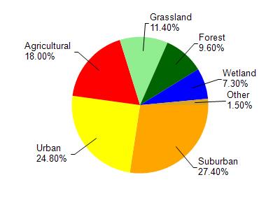
Pigeon Creek is located in the Milwaukee River South watershed which is 167.90 mi². Land use in the watershed is primarily suburban (27.40%), urban (24.80%) and a mix of agricultural (18%) and other uses (29.80%). This watershed has 203.63 stream miles, 13,038.94 lake acres and 5,996.03 wetland acres.
Nonpoint Source Characteristics
This watershed is ranked High for runoff impacts on streams, High for runoff impacts on lakes and High for runoff impacts on groundwater and therefore has an overall rank of High. This value can be used in ranking the watershed or individual waterbodies for grant funding under state and county programs.However, all waters are affected by diffuse pollutant sources regardless of initial water quality. Applications for specific runoff projects under state or county grant programs may be pursued. For more information, go to surface water program grants.