Adams, Portage
No
No
No
Fish and Aquatic Life
Overview
Fourteenmile Creek is a nineteen-mile warm water game fishery and is a tributary to the Wisconsin River. The stream has been impounded at three locations to form the Tri-Lakes (Arrowhead, Sherwood, and Camelot) region. Intense housing development occurs around each lake. The Tri-Lakes Lake Association is very active in aquatic plant harvesting.
Fishery surveys completed in 1998 found some game fish and several species of forage fish. Limiting factors to in-stream habitat include; streambank erosion, shallow channel depth, sedimentation from surrounding crop fields and the lack of pools, riffles and fish cover. HBI results suggest there is significant organic loading to the stream. Stream flow fluctuations are evident in the stream channel, likely a result of water usage by upstream cranberry operations. There are several cranberry operations that discharge water to the ditches. These discharges could contain sediment and nutrients that may be impacting the stream.
Date 2002
Author Aquatic Biologist
Historical Description
Fourteenmile Creek, T20N, R5E, Section 10 Surface Acres = 33.9, Miles = 10.
This light brown, hard water stream has a sand bottom and flows in a westerly direction into Petenwell Lake. The fishery consists primarily of northern pike and forage species. Relatively few largemouth bass are present in the stream immediately above Deer Lodge Lake, which is an impoundment on the Creek. Beaver are present. Wood duck and mallard broods may be seen during the summer. Access is possible from Petenwell Lake and Deer Lodge Lake; small craft may be navigated; and there are six road crossings.
From: Klick, Thomas A. and C.W. Threinen. 1966. Surface Water Resources of Adams County: Lake and Stream Classification Project. Wisconsin Conservation Department, Madison, WI.
Date 1966
Author Aquatic Biologist
General Condition
Fourteenmile Creek was assessed during the 2018 listing cycle; new total phosphorus sample data were clearly below the 2018 WisCALM listing thresholds for the Fish and Aquatic Life use. This water was meeting this designated use and was not considered impaired.
Date 2017
Author Ashley Beranek
Condition
Wisconsin has over 84,000 miles of streams, 15,000 lakes and milllions of acres of wetlands. Assessing the condition of this vast amount of water is challenging. The state's water monitoring program uses a media-based, cross-program approach to analyze water condition. An updated monitoring strategy (2015-2020) is now available. Compliance with Clean Water Act fishable, swimmable standards are located in the Executive Summary of Water Condition in 2018. See also the 'monitoring and projects' tab.
Reports
Recommendations
Citizen-Based Stream Monitoring
Collect chemical, physical, and/or biological water quality data to assess the current overall stream health. The data can inform management decisions and may be used to identify impaired waters for biennial lists.
Nutrient Strategy Priority
Adams County proposes to develop nutrient management plans for 4,470 acres of crop land within the Tri-Lakes Watershed. Major project elements to include: a) outreach to landowners, b) development of nutrient management plans, c) weekly water sampling, d) water quality analysis, and e) cost share payments.
Shoreland Ordinance
Adams County proposes to amend or create a shoreland zoning ordinance that complies with the requirements of NR 115, Wisconsin Administrative Code (as revised effective February 1, 2010) and retain existing regulations that exceed the water resource protections of NR 115 or are specific or unique to local needs.
Water Quality Modeling
Adams County proposes to provide up to 75% of the cost of shoreland restoration practices to lake front property owners on the Petenwell Flowage. Grant funds will be distributed to fund removal of sea walls, minor bank re-shaping, placement of rip-rap, establishment of vegetative buffers and implementation if individual stormwater management plans.
Management Goals
Wisconsin's Water Quality Standards provide qualitative and quantitative goals for waters that are protective of Fishable, Swimmable conditions [Learn more]. Waters that do not meet water quality standards are considered impaired and restoration actions are planned and carried out until the water is once again fishable and swimmable
Management goals can include creation or implementation of a Total Maximum Daily Load analysis, a Nine Key Element Plan, or other restoration work, education and outreach and more. If specific recommendations exist for this water, they will be displayed below online.
Monitoring
Monitoring the condition of a river, stream, or lake includes gathering physical, chemical, biological, and habitat data. Comprehensive studies often gather all these parameters in great detail, while lighter assessment events will involve sampling physical, chemical and biological data such as macroinvertebrates. Aquatic macroinvertebrates and fish communities integrate watershed or catchment condition, providing great insight into overall ecosystem health. Chemical and habitat parameters tell researchers more about human induced problems including contaminated runoff, point source dischargers, or habitat issues that foster or limit the potential of aquatic communities to thrive in a given area. Wisconsin's Water Monitoring Strategy was recenty updated.
Grants and Management Projects
Monitoring Projects
| WBIC | Official Waterbody Name | Station ID | Station Name | Earliest Fieldwork Date | Latest Fieldwork Date | View Station | View Data |
|---|
| 1377500 | Fourteenmile Creek | 013173 | Fourteen Mile Creek (Ditch # 7) - CTH D | 10/11/2013 | 3/30/2026 | Map | Data |
| 1377500 | Fourteenmile Creek | 10009160 | Fourteen Mile Creek 5th Ave. Site 7 | 11/11/2017 | 12/10/2023 | Map | Data |
| 1377500 | Fourteenmile Creek | 10055624 | Fourteen Mile Creek at Townline Road | 2/26/2021 | 10/4/2023 | Map | Data |
| 1377500 | Fourteenmile Creek | 10021936 | S Curve On D South Side | | | Map | Data |
| 1377500 | Fourteenmile Creek | 10055484 | Fourteen Mile Creek, West of 5th Ave | 2/26/2021 | 10/4/2023 | Map | Data |
| 1377500 | Fourteenmile Creek | 10030250 | Fourteen Mile Creek at CTH W | 2/26/2021 | 10/4/2023 | Map | Data |
| 1377500 | Fourteenmile Creek | 10029987 | Ditch - S Curve on Hwy D S side | 6/12/1996 | 8/30/2017 | Map | Data |
| 1377500 | Fourteenmile Creek | 10055483 | Fourteen Mile Creek | 2/26/2021 | 10/4/2023 | Map | Data |
| 1377500 | Fourteenmile Creek | 10009159 | Fourteen Mile Creek Upstream Cth D Site 6 | 5/22/2009 | 10/4/2023 | Map | Data |
|
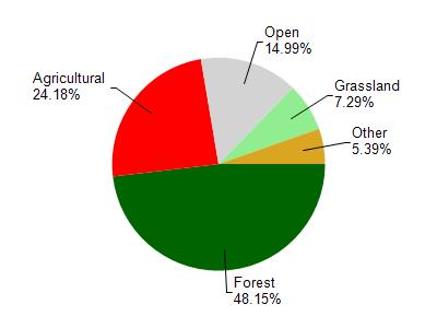
Watershed Characteristics
Fourteenmile Creek is located in the Fourteenmile Creek watershed which is 184.15 mi². Land use in the watershed is primarily forest (48.20%), agricultural (24.20%) and a mix of open (15%) and other uses (12.70%). This watershed has stream miles, lake acres and 11,432.03 wetland acres.
Nonpoint Source Characteristics
This watershed is ranked Medium for runoff impacts on streams, Medium for runoff impacts on lakes and High for runoff impacts on groundwater and therefore has an overall rank of High. This value can be used in ranking the watershed or individual waterbodies for grant funding under state and county programs.However, all waters are affected by diffuse pollutant sources regardless of initial water quality. Applications for specific runoff projects under state or county grant programs may be pursued. For more information, go to surface water program grants.