Juneau
No
No
Yes
Fish and Aquatic Life
Overview
The Baraboo River is a warm water sport fishery and canoe trail that is tributary to the Wisconsin River. The Baraboo River has historically had up to seven dams at one time along its entire length. Most of these dams were built to generate water power, although in the past years, they have been maintained mostly for recreational purposes. As a result of the habitat fragmentation and other problems caused by the dams on the river, the two miles of the river that flows through the City of Baraboo has been listed on the state's list of impaired waters.
In the past few years, there has been a strong movement to remove these dams from the river and once again open the channel up for free migration by fish, open navigation for recreational purposes, and re-establishment of the free-flowing river. The City of Baraboo in the Lower Baraboo River Watershed was the home of three of these dams. All three dams have now been removed. Prior to the removal of the third dam in October 2001, the removal of the other two opened up 5 miles of rock riffles, which had a three-fold effect:
1. Increased spawning area for walleye, sturgeon, suckers (and paddlefish if they can get around Prairie du Sac dam);
2. Creation of a "food factory" for the fish on the rock riffle area;
3. Opening up of natural, seasonal movement throughout the Baraboo River system.
It is the hope of all of the partners involved that even greater effects will be seen in the river as a result of the restoration of the river to its free-flowing condition. Monitoring will be conducted to determine the overall impact of the removal of the dams on the river. A rare aquatic species has been found in the river in past surveys. As a result of the dam removals, the process has begun to take this segment of the river off of the impaired waters list.
The Citizens for Waterfront Revitalization have received a River Planning Grant to develop a cooperative strategic plan for the Baraboo Rapids area of the river. This area is from the Highway 12 bridge in West Baraboo to the Highway 113 bridge east of the city. The plan will address some of the watershed-wide issues that affect the river. There is a USGS gauging station near Baraboo. The Baraboo River from Wonewoc to Reedsburg is considered a warm water sport fishery. The former dam at LaValle impounded water on the Baraboo River to form the LaValle Millpond. This dam was removed in 2000. Currently, a restoration plan is being developed or the old mill pond area of the river near LaValle. Despite the efforts of the nonpoint source priority watershed project, the river continues to be threatened by sources of nonpoint pollution. A rare aquatic species has been found in the river in past surveys.
From: Ripp, Coreen, Koperski, Cindy and Folstad, Jason. 2002. The State of the Lower Wisconsin River Basin.
PUBL WT-559-2002. Wisconsin Department of Natural Resources, Madison, WI.
Date 2002
Author Cynthia Koperski
Overview
From: Ripp, Coreen, Koperski, Cindy and Folstad, Jason. 2002. The State of the Lower Wisconsin River Basin.
PUBL WT-559-2002. Wisconsin Department of Natural Resources, Madison, WI.
Date 2002
Author Cynthia Koperski
Overview
Baraboo River in Narrows Creek and Baraboo River Watershed (LW22) - Just over 33 miles of the Baraboo River are in this watershed. The river supports a warm water sport fishery, is a major tributary to the Wisconsin River and is important as a smallmouth bass fishery. As a result of the habitat fragmentation and other problems caused by the dams on the river, the two miles of the river that flows through the City of Baraboo has been listed on the state’s list of impaired waters. The final dam was removed in October of 2001. The water quality and fishery of this up-stream portion of the river is expected to improve as a result of the dam removals. As a result, it is anticipated that this portion of the river will be able to be “de-listed.” The river receives discharges from Foremost Farms, North Freedom, Reedsburg, and Rock Springs in the watershed. A rare aquatic species has been found in the river in past surveys.
Baraboo River in Little Baraboo River Watershed (LW23) - The Baraboo River from Wonewoc to Reedsburg is considered a warm water sport fishery. The former dam at LaValle impounded water on the Baraboo River to form the LaValle Millpond. This dam was removed in 2000. Currently, a restoration plan is being developed for the old mill pond area of the river near LaValle. Despite the efforts of the nonpoint source priority watershed project, the river continues to be threatened by sources of nonpoint pollution. A rare aquatic species has been found in the river in past surveys.
From: Ripp, Coreen, Koperski, Cindy and Folstad, Jason. 2002. The State of the Lower Wisconsin River Basin.
PUBL WT-559-2002. Wisconsin Department of Natural Resources, Madison, WI.
Date 2002
Author Cynthia Koperski
Historical Description
This portion of the Baraboo River is classified as a warm water sport fishery for 15
miles of its length (Perrson, 1987), and as a Class II and Class III trout stream for 7.5
miles (WDNR, 1980). Heavy siltation adversely affects in-stream habitat in the Juneau
County portion (Ironside, 1991). Other nonpoint source water pollution problems
affect the stream. A dairy plant discharge to the Elroy wastewater treatment plant has
also led to water quality problenls in the past (WDNR, 1991). Water quality nlonitoring
of the Baraboo River in 1989 and 1990, downstreanl from the Kendall wastewater
treatment plant, identified water quality standards violations for dissolved oxygen. Instream
water temperature was also elevated (Sorge, 1991-1992).
Date 1994
Author Surface Water Inventory Of Wisconsin
Historical Description
A major tributary to the Wisconsin River which drains a large watershed west of the river. The stream is generally turbid and causes extensive flooding in spring. Complaints of flood damage brought recent inquiries from the Army Corps of Engineers regarding control needs. The entire stream in this county is traversible by outboard craft. Walleye, northern pike, bass, and panfishes (including catfish) constitute the fishery, however, fishing pressure is quite light. Access is provided by two state highway crossings, by a small road and wayside park, and by navigable water both upstream and downstream. Waterfowl are common along the river, especially wood ducks which utilize the bank trees and large instream snags. About 824 acres of wetland adjoin the stream.
Baraboo River T12N, R9E, Section 28
Surface Acres 151.5, Miles = 13.3, Gradient = 1.88 feet per mile
From: Poff, Ronald J. and C.W. Threinen, 1965. Surface Water Resources of Columbia County: Lake and Stream Classification Project. Wisconsin Department of Conservation, Madison, WI.
Date 1965
Author Aquatic Biologist
Recommendations
Monitor Water Quality or Sediment
Heavy rainfall prior to monitoring, poor transparency, need to repeat large river FIBI. AU: 944741; Station ID: (specific station/location of IBI needed)
Rivers Management Grant
This project provided an inventory the Baraboo River including documenting habitat, erosion areas, and bank vegetation.
The work involved identifying environmental, recreational, educational, water quality and habitat improvements through a series of stakeholder focus groups.
This work will result in confirming the goals and objectives for the Baraboo River, and developing conceptual plans for recreational, water quality, and habitat improvements.
The end result report will make recommendations for shoreline restoration, fish habitat, and native vegetation plantings that will reduce runoff to the Baraboo River.
This project includes the City of Reedsburg, Sauk County, Villages of Rock Springs and La Valle.
The workshops and meetings will be held with local decision makers and the grant will support creating press releases and community websites to share project findings.
The deliverables include a river corridor inventory and analysis, stakeholder needs assessment and recommendations to improve fish habitat, river access, and water quality. and conceptual plans to include prioritizing actions and costs..
Rivers Management Grant
Project Summary: To restore eroded shoreline and develop fish habitat improvement projects for the Baraboo River, within the village of North Freedom. To protect the corridor's natural setting, and improve it through planting native shoreline plants. To reduce non-point runoff and stream siltation, ultimately improving stream water quality. Removal of dead debris and trees will be necessary to grade the banks and install riprap. Removed trees will be incorporated into fish habitat at the site. Deliverables: Stabilize banks to reduce bank erosion and stream sedimentation. Improve public access to the shore using cut in points within riprap and through removal of existing fencing on the shoreline. Installation of in stream habitat that will provide large river fish habitat, and improve shoreline angling opportunities. Native vegetation plantings on the shoreline to improve shoreline wildlife habitat. Project results will be shared with the public via a press release and through the Friends of the Baraboo River Group.
Restore Riparian Habitat
Deliverables: Identify and prioritize areas with steep slopes in need of shoreline protection and enhancement of fish habitat. Identify areas of native vegetation to be protected, and areas of critical habitat. Output preliminary hydraulic calculations to ensure flood elevations do not increase if shoreline and habitat practices are put in place. Estimates of costs to implement specific practices will be included. Identify specific shoreline and fish habitat techniques appropriate for large rivers. Plans will be shared with conservation organizations, paddling clubs, the public and communities will post results on their websites. The Friends of Baraboo River will coordinate outreach and education efforts. The communities of Baraboo, West Baraboo and North Freedom will hire a consultant to implement final designs.
County Land and Water Management Plan
The Columbia County Land and Water Conservation Department together with the Farming and Conservation Together (FACT) committee will continue to work with landowners on an individual basis to implement conservation practices and restore wetlands while maintaining compatible agricultural operations. They will expand and coordinate voluntary programs for landowners, provide conservation agricultural practice demonstration sites and habitat restoration sites, work with landowners to control and abate wildlife damage, and protect private property rights of landowners by maintaining voluntary involvement in programs.
County Land and Water Management Plan
Sauk County Land Conservation will utilize the grant funds to support a conservation specialist who will coordinate Farming and Conservation Together (FACT), further building FACT as a river protection initiative and improving the health of the Lower Baraboo River.
Rivers Management Grant
Citizens for Waterfront Revitalization will organize and involve the many groups and state agencies that have been involved with the Baraboo River in order to create a comprehensive plan for the Baraboo Rapids Area of the river. This will enable these groups to put the efforts of their combined memberships into working on common goals in an orderly fashion.
Restore Wetlands
Restore Wetlands
Restore Wetlands
Restore Wetlands
Restore Wetlands
Restore Wetlands
Restore Wetlands
Restore Wetlands
Restore Wetlands
Restore Wetlands
Restore Wetlands
Restore Wetlands
Restore Wetlands
Restore Wetlands
Restore Wetlands
Restore Wetlands
Restore Wetlands
Restore Wetlands
Restore Wetlands
Restore Wetlands
Sewer Service Area Planning
The Baraboo SSA Plan was created in 2002 and updated in 2006 and 2009 by the City of Baraboo
Management Goals
Wisconsin's Water Quality Standards provide qualitative and quantitative goals for waters that are protective of Fishable, Swimmable conditions [Learn more]. Waters that do not meet water quality standards are considered impaired and restoration actions are planned and carried out until the water is once again fishable and swimmable
Management goals can include creation or implementation of a Total Maximum Daily Load analysis, a Nine Key Element Plan, or other restoration work, education and outreach and more. If specific recommendations exist for this water, they will be displayed below online.
Monitoring
Monitoring the condition of a river, stream, or lake includes gathering physical, chemical, biological, and habitat data. Comprehensive studies often gather all these parameters in great detail, while lighter assessment events will involve sampling physical, chemical and biological data such as macroinvertebrates. Aquatic macroinvertebrates and fish communities integrate watershed or catchment condition, providing great insight into overall ecosystem health. Chemical and habitat parameters tell researchers more about human induced problems including contaminated runoff, point source dischargers, or habitat issues that foster or limit the potential of aquatic communities to thrive in a given area. Wisconsin's Water Monitoring Strategy was recenty updated.
Grants and Management Projects
Monitoring Projects
| WBIC | Official Waterbody Name | Station ID | Station Name | Earliest Fieldwork Date | Latest Fieldwork Date | View Station | View Data |
|---|
| 1271100 | Baraboo River | 573198 | Baraboo River - Baraboo R 20 Elroy | | | Map | Data |
| 1271100 | Baraboo River | 10012192 | Baraboo River - Schaller Rd (Hann St) | 7/3/2014 | 7/3/2014 | Map | Data |
| 1271100 | Baraboo River | 10013899 | Baraboo River Station 1-1962- Ne1/4 Ne1/4 Sec 32-Starts At Town Bridge In Village Of Elroy | 5/8/2012 | 1/1/2015 | Map | Data |
| 1271100 | Baraboo River | 293065 | Baraboo River - Sth 80 - 82 Sec. 4 | 5/8/1979 | 1/1/2015 | Map | Data |
| 1271100 | Baraboo River | 10032338 | Baraboo River at Hwy. O bridge Elroy | | | Map | Data |
| 1271100 | Baraboo River | 10043605 | Baraboo River at STH 33 | 9/3/2014 | 1/1/2015 | Map | Data |
| 1271100 | Baraboo River | 293011 | Baraboo River - Union Center Stp | 11/14/1977 | 10/13/2004 | Map | Data |
| 1271100 | Baraboo River | 293066 | Baraboo River - Cth FF Sec. 35 (Bi) | 5/8/1979 | 1/1/2015 | Map | Data |
|
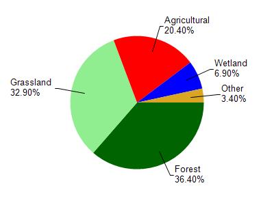
Watershed Characteristics
Baraboo River is located in the Crossman Creek and Little Baraboo River watershed which is 213.80 mi². Land use in the watershed is primarily forest (36.40%), grassland (32.90%) and a mix of agricultural (20.40%) and other uses (10.30%). This watershed has 466.61 stream miles, 244.11 lake acres and 6,321.59 wetland acres.
Nonpoint Source Characteristics
This watershed is ranked Not Available for runoff impacts on streams, Not Available for runoff impacts on lakes and High for runoff impacts on groundwater and therefore has an overall rank of High. This value can be used in ranking the watershed or individual waterbodies for grant funding under state and county programs.However, all waters are affected by diffuse pollutant sources regardless of initial water quality. Applications for specific runoff projects under state or county grant programs may be pursued. For more information, go to surface water program grants.