Milwaukee
No
No
Yes
Fish and Aquatic Life
Overview
Lincoln Creek, in the Milwaukee River South Watershed, is a 9.70 mile river that falls in Milwaukee County. This river is managed for fishing and swimming and is currently considered impaired.
Date 2011
Author Aquatic Biologist
Historical Description
Lincoln Creek Subwatershed, located in northwest Milwaukee County in the southwestern part
of the watershed, is drained by a perennial stream tributargr to the Milwaukee River.
Water Resources - Lincoln Creek, roughly 9.2 miles long, is located entirely in Milwaukee
Gunty and drains 19.3 square miles of the civil divisions of Milwaukee, Glendale, and Brown
Deer. Lincoln Creek discharges to the Milwaukee River and the Etabrook-Lincoln Greek Park
impoundment at T8N R22E, Sec.31, SE of NE quarter. Water resource conditions vary within
thc stream. As a result, biological use classifications have been assigned by individual segments.
Segment #I, downstream of Teutonia Ave. to the stream9s confluence with the Milwaukee
River, is rated for full fish and aquatic life (FAL-B). Segment #2, upstream of Teutonia Ave.
to the 32nd St. drop structure and from Hampton Ave. to the drop structure upstream of Silver
Spring Dr., is concrete-lined and rated marginal for fish and aquatic life (
#6, a short concrete-lined reach downstream of headwaters at 76th St., is alsorated marginal
for fish and aquatic life (MAR-E). Segment #3, 32nd St. to 35th St., segment #4, 35th St. to a
concrete drop structure near 47th St., segment Rc5, from the concrete drop structure at 47th St.
to Hampton Ave., segment #7, from the drop structure at Silver Spring Dr. to Mill Rd., and
segment #8, from Mill Rd. to ponds located on the Brynwood Country Club property upstream
of 60th St., are all rated intermediate for fish and aquatic life (INT-D).
Instream habitat varies, generally ranging from "absent" in the concrete-lined segments to "poor
to fair" within those segments still in earthen channels. Hydraulic scour, lack oE cover, bank
erosion and failure, shallow water depths, and sedimentation, all the direct result of excessive
hydraulic loading and past channelization, are the most severe limiting factors. Water quality in
Lincoln Creek was rated "very poor" using the Hilsenhoff Biotic Index in 1982. Benthic
organisms were nearly absent, indicating severe or toxic water quality conditions. All stream
segments in earthen channels are currently not meeting their full biological and recreation0d l usc
classifications. Observed or potential problems limiting full use potential include loss of
instream and riparian habitat through sedimentation, low dissolved oygen, bacteria, and toxics.
Factors contributing to these problems include concrete channelization of other stream sections,
fish migration barriers, hydraulic scour which alters the substrate by removal of fine-grained
material such as sand, urban runoff, bank erosion, spills, "conventional" pollutants such as
nutrients, toxics and bacterial pollutant loadings from combined sewer and sanitary sewer
overflows, leachate from landfills, and potentially toxic sediments (including PCBs and metals
such as lead, copper, zinc, chromium, and iron). Stream bottom sediments, analyzed for a
limited number of metals and/or PCBs in 1975, would be rated "heavily pollutedn by lead and
zinc and "moderately polluted" by chromium, copper and nickel.
Date 1992
Author Surface Water Inventory Of Wisconsin
Historical Description
PCBs were present in concentrations ranging from 3.2-7.5 m&. Likely sources of heavy metals and PCBs in Lincoln Creek are municipal and industrial p i n t sources, spills, illegal discharges and urban nonpoint source runoff. There are 18 known industrial dischargers, 15 of which are non-contact cooling water, and at least 55 municipal sanitaly sewer relief devices or combined sewers that discharge
to Lincoln Creek. Two of the non-contact cooling water discharges include water treatment or biocide additives. These dischargers are not permitted to add pollutants to their effluent, but concern has been raised about potential chlorine toxicity, as all industries discharging cooling water obtain that water from the city of Milwaukee public water supply. A total residual chlorine concentration of 0.5-1.0 mg/l is maintained in the city of Milwaukee public water distribution system and may therefore contribute to potential chlorine toxicity. Prior to 1983, iron sulfate and other heavy metals were being discharged randomly from abandoned acid pits
("pickling liquor") on the kO.Smith property. Although remedial control measures have been implemented, the events continue and other dischargers may be responsible for these incidents.
Industrial spills (intentional or accidental) and landfill leachate discharges continue to be a significant problem limiting Lincoln Creek water quality, as does bacterial contamination from urban runoff and the combined and sanitary sewer overflows.
Lincoln Creek is classified as supporting "partial-body contact" forms of recreational use although frequent bacterial and other pollutant contamination severely limits this use.
Fisheries - Lincoln Creek is the largest perennial tributary to the lower Milwaukee River, but has been lined with concrete, straightened or dredged for nearly its entire length. Only the lowermost reaches, dredged but otherwise left in a semi-natural state, are still used by smallmouth and largemouth bass, crappie, northern pike, redhorse and numerous other native species. Largemouth bass, green sunfish and a few species of minnows can also be found in a few of the less-altered upstream reaches.
Concrete channelization, and the extreme fluctuations in stream Row that have resulted, are the principal factors limiting fisheries in this stream. The resultant destabilized hydrology of the stream systems has also precipitated extensive habitat degradation in the few remaining natural reaches through streambank erosion, loss of riparian vegetation and cover, inadequate summer Rows/increased water temperatures, and substrate scouring which inhibits successful spawning and production of insects, a critical food item for most fish species. Toxic discharges and the related fish kills continue to suppress the fisheries potential of Lincoln Creek and the Milwaukee River to which it flows.
Date 1992
Author Surface Water Inventory Of Wisconsin
Historical Description
Wildlife - There are no riparian wetlands within the subwatershed. Wetland restoration or creation of waterfowl pair ponds at Have Nature Preserve is possible. Approximately 53 percent of the riparian area is open space and the remaining 47 percent is urbanized. I Parks - The only state-owned recreation site in the entire Milwaukee River South Watershed, the 237-acre Navenw Environmental Awareness Center, is lscated in this subwatershed. Havenwoods lies adjacent to Lincoln Creek, much of which is concrete-channelized. This site offers educational programs and nature study to school groups and youth groups, and is open to all state residents. Eleven of the forty four Milwaukee County park sites are located in this subwatershed as well.
They encompass a total of 262 acres of recreational open space. None of these sites are located along a riparian corridor. Columbus, Wyrick, Lindsay, Meaux, Nash, Schoenecker, Vogel, Wahl, and Smith Parks are small neighborhood sites under county jurisdiction. The two largest sites in this subwatershed are Dineen and McGovern County Parks. Dineen Park, 59 acres in size, has both swimming and wading pools, a fishing pond, picnic areas, four tennis courts, a nine-hole golf course, ice skating rink, playing fields, and one of only two lawn bowling greens located in the county park system. The 70-acre McGovern Park offers swimming and wading pools, six tennis courts, picnic areas, playing fields, and fishing in and ice skating on the two ponds located in the park. In addition, there are 14 community-owned sites. All of these are located in the city of Milwaukee and include municipal playlots, totlots or playgrounds, and open space sites. The 191-acre Brym and 157-acre Tripoli private country clubs also are located in this subwatershed. Although neither are located along streams, ponds have been dug on the golf couhses at each of these sites. In addition, there are about two miles of environmental corridor lands, identified by SEWRPC, located along the mainstem Milwaukee River.
Land acreage is currently under management of the Forest Tax laws (FCL, MFL) because of the urbanid nature of this subwatershed and no Conservation Reserve
Program (CRP) tree planting urs. A scattering of black walnut trees throughout the
subwatershed leads to numerous requests by the urban landowners for information on the removal and marketing of backyard walnut trees. Private, parochial, and public schools participate 's "Free Tree Program" for fourth-grade students. Demonstration forest on the Haven operv, designated as a state forat preserve, is planned. In addition, this center offers "Project Learning Tree" to interested teachers. Little impact information is available concerning d the dump site in
the old tom of GranGlle. mree sits, the U.Se SF, and the U.S.
Date 1992
Author Surface Water Inventory Of Wisconsin
Historical Description
Disciplinaly Barracks, all located in the city of Milwaukee, are suspected of negatively influencing Lincoln Creek. The Hercules Gompany in the city of Milwaukee may be a former spill site, not an actual landfill. The Reuben Katz and the AO. Smith lagoon in the city of Milwaukee are problem sites with caustic contamination at Reuben Katz and a cutoff well and ongoing monitoring at the lagoon. The city of Milwatakee dump site in the city of Milwaukee is a storage facility for Commerce Industrial Ct~emical ampany and has been inspected recently by the EPA No data results are available at this time. Lincoln Creek flows through the Whitefish Bay Ash Site in the village of Whitefak Bay. Discharge either to or from the creek is suspected, but little information is available at this time. The other two sites, the Johnson Controls-Battery Division(#2) and another site designated as "Not available" are both located in the city of Milwaukee and no information is available mncerning their respective water resource impact.
- The Lincoln Creek subwatershed is served by municipal water from Lake
Michigan. There are no community systems and minimal private well usage.
- Regular program activities ur on a case-bycase basis and are in response to actions or requests from individuals. These activities include protection of wetlands through review and regulation of county wetland/shoreland ordinances and
incorporation of watershed objectives into projecb requiring water regulation permits. Additional program responsibilities include the review of and response to the Federal Clean Water Act, Section 404 applications to fill small wetlands, to assist with and oversee adoption of ordinances for the city of Milwaukee, and to evaluate and assist with the SD Stormwater Control project.
Wastewater - This subwatershed, in the city of Milwaukee, is served by the Milwaukee Metropolitan Sewerage District (MMSD) municipal wastewater treatment plant. The MMSD municipal treatment plants are regulated by the Department Wastewater Program and are described in detail with recommendations in Section C, the Point Source Report. Combined sewers and sanitary sewers occasionally discharge to Lincoln Creek.
- Established urban areas contribute 85 percent of the sediment loads to
Lincoln Creek; eroding stream banks contribute the remainder. Established urban areas contribute over 5500 tons of sediment annually. This represents over 50 percent of the total urban sediment load in the entire watershed, and nearly 25 percent of the total sediment load from all sources in the entire watershed. Lincoln Creek receives an estimated annual lead load of approximately 10,000 pounds, in addition to other toxicants present in the storm water runoff.
Date 1992
Author Surface Water Inventory Of Wisconsin
Recommendations
Citizen-Based Stream Monitoring
Collect chemical, physical, and/or biological water quality data to assess the current overall stream health. The data can inform management decisions and may be used to identify impaired waters for biennial lists.
Citizen-Based Stream Monitoring
Collect chemical, physical, and/or biological water quality data to assess the current overall stream health. The data can inform management decisions and may be used to identify impaired waters for biennial lists.
Citizen-Based Stream Monitoring
Collect chemical, physical, and/or biological water quality data to assess the current overall stream health. The data can inform management decisions and may be used to identify impaired waters for biennial lists.
Stormwater Planning, Implementation
To arrest the negative impacts of nonpoint source pollution, the Milwaukee Metropolitan Sewerage District seeks to innovate a subsurface gravel wetland that holds rainwater where it falls, infiltrates and filters it, absorbs it through plant root systems, and evapotranspires it to the atmosphere. Through this project, the Sewerage District will implement this innovative infrastructure measure in the Green Tree Basin on Lincoln Creek, a tributary of the Milwaukee River, to address six beneficial use impairments in the Milwaukee Estuary Area of Concern.
Rivers Management Grant
The Foundation will assist in the development of a new river management organization. Assisting in identifying local businesses, neighborhood associations, institutions, and schools willing to become fonding members of the Lincoln Creek Watershed Association. Their goal is to develop stewardship focus areas and capacity building through a workshop series linking organizational development, a strategic plan, and sustainability to waterhed protection and water quality management.
Management Goals
Wisconsin's Water Quality Standards provide qualitative and quantitative goals for waters that are protective of Fishable, Swimmable conditions [Learn more]. Waters that do not meet water quality standards are considered impaired and restoration actions are planned and carried out until the water is once again fishable and swimmable
Management goals can include creation or implementation of a Total Maximum Daily Load analysis, a Nine Key Element Plan, or other restoration work, education and outreach and more. If specific recommendations exist for this water, they will be displayed below online.
Monitoring
Monitoring the condition of a river, stream, or lake includes gathering physical, chemical, biological, and habitat data. Comprehensive studies often gather all these parameters in great detail, while lighter assessment events will involve sampling physical, chemical and biological data such as macroinvertebrates. Aquatic macroinvertebrates and fish communities integrate watershed or catchment condition, providing great insight into overall ecosystem health. Chemical and habitat parameters tell researchers more about human induced problems including contaminated runoff, point source dischargers, or habitat issues that foster or limit the potential of aquatic communities to thrive in a given area. Wisconsin's Water Monitoring Strategy was recenty updated.
Grants and Management Projects
Monitoring Projects
| WBIC | Official Waterbody Name | Station ID | Station Name | Earliest Fieldwork Date | Latest Fieldwork Date | View Station | View Data |
|---|
| 19400 | Lincoln Creek | 10041955 | Estabrook Impoundment Zone 2 | 10/10/2002 | 10/10/2002 | Map | Data |
| 19400 | Lincoln Creek | 10043574 | Lincoln Creek at Meaux Park | 1/1/2015 | 11/1/2024 | Map | Data |
| 19400 | Lincoln Creek | 10038205 | LINCOLN CREEK AT GREEN BAY AVENUE | 10/27/1992 | 11/12/2025 | Map | Data |
| 19400 | Lincoln Creek | 10047561 | Lincoln Creek west of railroad yard | 8/23/2017 | 8/23/2017 | Map | Data |
| 19400 | Lincoln Creek | 10047565 | Lincoln Creek west of railroad yard 2 | 9/29/2017 | 9/29/2017 | Map | Data |
| 19400 | Lincoln Creek | 10037164 | Lincoln Creek - Estabrook Impoundment (EST 5-9) | 9/25/2002 | 9/25/2002 | Map | Data |
| 19400 | Lincoln Creek | 10038207 | Lincoln Creek - DS of Green Tree Rd | 10/14/1992 | 11/6/1992 | Map | Data |
| 19400 | Lincoln Creek | 413804 | Lincoln Creek - Sediment Trap /Havenwoods | 10/22/1992 | 10/9/1995 | Map | Data |
| 19400 | Lincoln Creek | 10004047 | Lincoln Creek - 47 And Congress St | | | Map | Data |
| 19400 | Lincoln Creek | 413079 | Lincoln Creek at Congress And 40th St | 5/29/1975 | 4/13/1976 | Map | Data |
| 19400 | Lincoln Creek | 413242 | Phoenix Products Company - 004 | | | Map | Data |
| 19400 | Lincoln Creek | 10010570 | Lincoln Creek - 4 | 5/11/1992 | 1/1/2015 | Map | Data |
| 19400 | Lincoln Creek | 413744 | Lincoln Creek at Green Tree Road | | | Map | Data |
| 19400 | Lincoln Creek | 413781 | Lincoln Creek Tributary at Ruby Outlet At Milwaukee WI | 4/8/1996 | 9/8/1996 | Map | Data |
| 19400 | Lincoln Creek | 413041 | Sterling Tool And Mfg Co 001 | | | Map | Data |
| 19400 | Lincoln Creek | 10010571 | Lincoln Creek 23 | | | Map | Data |
| 19400 | Lincoln Creek | 10014169 | Lincoln 8 | 1/1/2015 | 1/1/2015 | Map | Data |
| 19400 | Lincoln Creek | 413924 | Lincoln Creek at 27th St At Milwaukee WI | 6/3/2002 | 9/24/2003 | Map | Data |
| 15000 | Milwaukee River | 10037125 | Milwaukee River - Estabrook Impoundment (EST 4-15) | 10/30/2001 | 10/30/2001 | Map | Data |
| 19400 | Lincoln Creek | 413736 | Lincoln Creek 5 at Hampton Ave. | 9/29/2017 | 9/29/2017 | Map | Data |
| 15000 | Milwaukee River | 10041955 | Estabrook Impoundment Zone 2 | 10/10/2002 | 10/10/2002 | Map | Data |
| 19400 | Lincoln Creek | 413737 | Lincoln Creek at 56th and Lincoln Dr | 6/7/2008 | 11/6/2016 | Map | Data |
| 19400 | Lincoln Creek | 10012162 | Lincoln Creek - Lincoln 6 | 3/26/2007 | 1/1/2015 | Map | Data |
| 19400 | Lincoln Creek | 10037165 | Lincoln Creek - Estabrook Impoundment (EST 5-10) | 9/25/2002 | 9/25/2002 | Map | Data |
| 15000 | Milwaukee River | 10037124 | Milwaukee River - Estabrook Impoundment (EST 4-14) | 10/30/2001 | 10/30/2001 | Map | Data |
| 19400 | Lincoln Creek | 10012805 | Lincoln Creek 6 | | | Map | Data |
| 19400 | Lincoln Creek | 10004044 | Lincoln Creek at Meaux Park | 10/15/1992 | 5/17/1993 | Map | Data |
| 19400 | Lincoln Creek | 413748 | Lincoln Creek at Green Bay Ave. | | | Map | Data |
| 19400 | Lincoln Creek | 10037201 | Lincoln Creek - Estabrook Impoundment (5X2) | 8/6/2003 | 8/6/2003 | Map | Data |
| 15000 | Milwaukee River | 415034 | Milwaukee River - Lincoln Creek - Lincoln Park West Oxbow | | | Map | Data |
| 19400 | Lincoln Creek | 413743 | Lincoln Creek at 60th St. | 10/9/1995 | 6/22/2019 | Map | Data |
| 19400 | Lincoln Creek | 10012073 | Lincoln Creek - Lincoln 1 | 3/26/2007 | 10/4/2017 | Map | Data |
| 19400 | Lincoln Creek | 10037170 | Lincoln Creek - Estabrook Impoundment (EST 5-15) | 9/25/2002 | 9/25/2002 | Map | Data |
| 19400 | Lincoln Creek | 413738 | Lincoln Creek at 47th Street At Milwaukee WI | 10/2/1992 | 11/12/2025 | Map | Data |
| 19400 | Lincoln Creek | 10037160 | Lincoln Creek - Estabrook Impoundment (EST 5-5) | 9/25/2002 | 9/25/2002 | Map | Data |
| 19400 | Lincoln Creek | 10038206 | LINCOLN CREEK AT 61ST ST N AND HAMPTON AVE W | 10/2/1992 | 10/2/1992 | Map | Data |
| 19400 | Lincoln Creek | 10047563 | Lincoln Creek bridge at N 51st Blvd | 10/3/2017 | 10/3/2017 | Map | Data |
| 19400 | Lincoln Creek | 413637 | Lincoln Creek - W Congress Or Storm Sewer | | | Map | Data |
| 15000 | Milwaukee River | 413796 | Milwaukee River - Estabrook Impoundment | 9/25/1995 | 9/25/1995 | Map | Data |
| 19400 | Lincoln Creek | 413239 | Phoenix Products Company - 001 | | | Map | Data |
| 15000 | Milwaukee River | 10037107 | Milwaukee River - Estabrook Impoundment (EST 4-16) | 10/30/2001 | 10/30/2001 | Map | Data |
| 19400 | Lincoln Creek | 10047560 | Lincoln Creek bridge at N Sherman Blvd | 8/23/2017 | 8/23/2017 | Map | Data |
| 19400 | Lincoln Creek | 413778 | Lincoln Creek at Silver Spring Rd | 4/18/2001 | 10/3/2017 | Map | Data |
| 19400 | Lincoln Creek | 10037156 | Lincoln Creek - Estabrook Impoundment (EST 5-1) | 9/25/2002 | 9/25/2002 | Map | Data |
| 19400 | Lincoln Creek | 413746 | Lincoln Creek at 32 St. | 5/11/1992 | 1/1/2015 | Map | Data |
| 19400 | Lincoln Creek | 10037171 | Lincoln Creek - Estabrook Impoundment (EST 5-16) | 9/25/2002 | 10/17/2017 | Map | Data |
| 19400 | Lincoln Creek | 413749 | Lincoln Creek at 47th Street At Milwaukee Wi And Settling Tank Outlet/Inlet | 3/24/1993 | 10/3/2017 | Map | Data |
| 19400 | Lincoln Creek | 10037162 | Lincoln Creek - Estabrook Impoundment (EST 5-7) | 9/25/2002 | 9/25/2002 | Map | Data |
| 19400 | Lincoln Creek | 10010573 | Lincoln Creek 5 | 3/26/2007 | 1/1/2015 | Map | Data |
| 19400 | Lincoln Creek | 413070 | Lincoln Creek at Teutonia Avenue | 5/8/1975 | 4/13/1976 | Map | Data |
| 19400 | Lincoln Creek | 10004042 | Lincoln Creek at 51st And Woolworth | 11/18/1992 | 1/1/2015 | Map | Data |
| 19400 | Lincoln Creek | 10010572 | Lincoln Creek | | | Map | Data |
| 19400 | Lincoln Creek | 10012164 | Lincoln Creek - Lincoln 8 | 5/5/1994 | 1/1/2015 | Map | Data |
| 19400 | Lincoln Creek | 10014166 | Lincoln 4 (at47th) | 5/17/1993 | 1/1/2015 | Map | Data |
| 19400 | Lincoln Creek | 10047394 | Wetland [ID 41423690655] | 9/29/2017 | 9/29/2017 | Map | Data |
| 19400 | Lincoln Creek | 10010581 | Lincoln Creek - 10 | 3/26/2007 | 1/1/2015 | Map | Data |
| 19400 | Lincoln Creek | 10010576 | Lincoln Creek 8 | 5/11/1992 | 1/1/2015 | Map | Data |
| 19400 | Lincoln Creek | 413739 | Lincoln Creek at 36 And Congress St | 10/7/1992 | 1/1/2015 | Map | Data |
| 19400 | Lincoln Creek | 10042764 | Lincoln Creek at Good Hope Road (Cty HWY PP) | 12/1/2000 | 12/1/2000 | Map | Data |
| 19400 | Lincoln Creek | 10047559 | Lincoln Creek footbridge at N 37th St | 8/23/2017 | 8/23/2017 | Map | Data |
| 15000 | Milwaukee River | 413226 | Milw San Sewer Overflow - 011 | | | Map | Data |
| 19400 | Lincoln Creek | 10010575 | Lincoln Creek - 7 | 3/26/2007 | 1/1/2015 | Map | Data |
| 19400 | Lincoln Creek | 10034036 | Lincoln Creek upstream from Cameron Ave W | 6/5/2009 | 1/1/2015 | Map | Data |
| 15000 | Milwaukee River | 10037116 | Milwaukee River - Estabrook Impoundment (EST 4-6) | 10/30/2001 | 10/30/2001 | Map | Data |
| 19400 | Lincoln Creek | 10037168 | Lincoln Creek - Estabrook Impoundment (EST 5-13) | 9/25/2002 | 9/25/2002 | Map | Data |
| 19400 | Lincoln Creek | 413809 | Crestwood Creek (Lincoln Creek) - Sediment Trap /100 Ft. Upstream From Lincoln Creek | | | Map | Data |
| 19400 | Lincoln Creek | 10037161 | Lincoln Creek - Estabrook Impoundment (EST 5-6) | 9/25/2002 | 9/25/2002 | Map | Data |
| 19400 | Lincoln Creek | 413240 | Phoenix Products Company - 002 | | | Map | Data |
| 15000 | Milwaukee River | 413794 | Milwaukee River - Estabrook Impoundment | 9/25/1995 | 9/25/1995 | Map | Data |
| 19400 | Lincoln Creek | 10012806 | Lincoln Creek 6 | | | Map | Data |
| 19400 | Lincoln Creek | 10047562 | Lincoln Creek footbridge at W Parkway Dr and N 49th St | 10/3/2017 | 2/23/2021 | Map | Data |
| 19400 | Lincoln Creek | 10047956 | Lincoln Creek DS N 60th Street | 1/1/2015 | 11/12/2025 | Map | Data |
| 19400 | Lincoln Creek | 10012165 | Lincoln Creek - Lincoln 9 | 3/26/2007 | 1/1/2015 | Map | Data |
| 19400 | Lincoln Creek | 10010574 | Lincoln Creek | | | Map | Data |
| 19400 | Lincoln Creek | 10037163 | Lincoln Creek - Estabrook Impoundment (EST 5-8) | 9/25/2002 | 9/25/2002 | Map | Data |
| 19400 | Lincoln Creek | 10037169 | Lincoln Creek - Estabrook Impoundment (EST 5-14) | 9/25/2002 | 9/25/2002 | Map | Data |
| 19400 | Lincoln Creek | 413018 | Stainless Foundry And Engine - 004 | | | Map | Data |
| 15000 | Milwaukee River | 413771 | Milwaukee River - Estabrook Impoundment Mb# Es-2 | 11/2/1993 | 11/2/1993 | Map | Data |
| 19400 | Lincoln Creek | 10037200 | Lincoln Creek - Estabrook Impoundment (5X1) | 8/6/2003 | 8/6/2003 | Map | Data |
| 19400 | Lincoln Creek | 413747 | Lincoln Creek at Teutonia Ave | 10/22/1992 | 10/9/1995 | Map | Data |
| 19400 | Lincoln Creek | 10014168 | Lincoln 6 (atW. Of Sheridan Avenue) | 1/1/2015 | 1/1/2015 | Map | Data |
| 19400 | Lincoln Creek | 413071 | Lincoln Creek at W Villard Nr 64th | 5/20/1975 | 9/14/2003 | Map | Data |
| 19400 | Lincoln Creek | 413808 | Lincoln Creek - Sediment Trap /Teutonia Road | | | Map | Data |
| 19400 | Lincoln Creek | 10004043 | Lincoln Creek - Havenwoods Env St | 11/11/1992 | 5/17/1993 | Map | Data |
| 19400 | Lincoln Creek | 10037811 | Lincoln Creek 35th and Congress | | | Map | Data |
| 19400 | Lincoln Creek | 413780 | Lincoln Creek Tributary at Ruby Inlet At Milwaukee WI | 4/8/1996 | 9/8/1996 | Map | Data |
| 19400 | Lincoln Creek | 413806 | Lincoln Creek - Sediment Trap /46th Street | 10/9/1995 | 3/11/2015 | Map | Data |
| 19400 | Lincoln Creek | 10034035 | Lincoln Creek downstream from Teutonia Ave | 6/5/2009 | 1/1/2015 | Map | Data |
| 15000 | Milwaukee River | 413795 | Milwaukee River - Estabrook Impoundment | 9/25/1995 | 9/25/1995 | Map | Data |
| 19400 | Lincoln Creek | 10014171 | Lincoln 10 | | | Map | Data |
| 19400 | Lincoln Creek | 10021069 | Lincoln Creek at mouth | 5/6/2007 | 1/1/2015 | Map | Data |
| 15000 | Milwaukee River | 10038701 | Milwaukee River - Estabrook Impoundment (4XX1) | 8/5/2003 | 8/5/2003 | Map | Data |
| 19400 | Lincoln Creek | 413745 | Lincoln Creek at Havenwoods Sv Dr | 10/22/1992 | 4/24/2007 | Map | Data |
| 19400 | Lincoln Creek | 413241 | Phoenix Products Company - 003 | | | Map | Data |
| 19400 | Lincoln Creek | 10037158 | Lincoln Creek - Estabrook Impoundment (EST 5-3) | 9/25/2002 | 9/25/2002 | Map | Data |
| 19400 | Lincoln Creek | 10038204 | LINCOLN CREEK AT 54TH ST | 10/7/1992 | 10/7/2017 | Map | Data |
| 19400 | Lincoln Creek | 10014165 | Lincoln 1- Betw. Lancaster & Fairmont | 1/1/2015 | 1/1/2015 | Map | Data |
| 19400 | Lincoln Creek | 413250 | Lincoln Creek at St Michels Hosp | | | Map | Data |
| 19400 | Lincoln Creek | 413636 | Lincoln Creek - Lincoln Creek Pkwy-Storm Sewer | | | Map | Data |
| 19400 | Lincoln Creek | 413807 | Lincoln Creek - Sediment Trap | | | Map | Data |
| 19400 | Lincoln Creek | 10037157 | Lincoln Creek - Estabrook Impoundment (EST 5-2) | 9/25/2002 | 9/25/2002 | Map | Data |
| 19400 | Lincoln Creek | 10037166 | Lincoln Creek - Estabrook Impoundment (EST 5-11) | 9/25/2002 | 9/25/2002 | Map | Data |
| 19400 | Lincoln Creek | 10058570 | Lincoln Creek at Orange Trail Bridge, Havenwoods | 11/7/2023 | 11/7/2023 | Map | Data |
| 19400 | Lincoln Creek | 10007801 | Lincoln Creek at Sherman Blvd. | 4/15/1994 | 5/27/2005 | Map | Data |
| 19400 | Lincoln Creek | 10014170 | Lincoln 9 (S. Of Green Tree Rd) | 1/1/2015 | 1/1/2015 | Map | Data |
| 15000 | Milwaukee River | 10037108 | Milwaukee River - Estabrook Impoundment (EST 4-17) | 10/30/2001 | 10/30/2001 | Map | Data |
| 19400 | Lincoln Creek | 413805 | Lincoln Creek - Sediment Trap /60th Street | 10/14/1992 | 10/14/1992 | Map | Data |
| 15000 | Milwaukee River | 10037115 | Milwaukee River - Estabrook Impoundment (EST 4-4) | 10/30/2001 | 10/30/2001 | Map | Data |
| 19400 | Lincoln Creek | 10037159 | Lincoln Creek - Estabrook Impoundment (EST 5-4) | 9/25/2002 | 9/25/2002 | Map | Data |
| 19400 | Lincoln Creek | 10037167 | Lincoln Creek - Estabrook Impoundment (EST 5-12) | 9/25/2002 | 9/25/2002 | Map | Data |
| 15000 | Milwaukee River | 10041956 | Milwaukee River - Estabrook Impoundment (EST 4-5) | 10/30/2001 | 10/30/2001 | Map | Data |
|
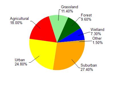
Watershed Characteristics
Lincoln Creek is located in the Milwaukee River South watershed which is 167.90 mi². Land use in the watershed is primarily suburban (27.40%), urban (24.80%) and a mix of agricultural (18%) and other uses (29.80%). This watershed has 203.63 stream miles, 13,038.94 lake acres and 5,996.03 wetland acres.
Nonpoint Source Characteristics
This watershed is ranked High for runoff impacts on streams, High for runoff impacts on lakes and High for runoff impacts on groundwater and therefore has an overall rank of High. This value can be used in ranking the watershed or individual waterbodies for grant funding under state and county programs.However, all waters are affected by diffuse pollutant sources regardless of initial water quality. Applications for specific runoff projects under state or county grant programs may be pursued. For more information, go to surface water program grants.