Door
No
No
No
Fish and Aquatic Life
Overview
Forestville Flowage is a 65-acre impoundment on the Ahnapee River at Forestville. It has a maximum depth of 5 feet. The village of Forestville owns and operates the dam that forms this impoundment. The upper Ahnapee River and the Forestville Flowage were chemically treated in 1984 to remove carp and bullheads.
They were later restocked with bass, panfish and northern pike (Meyers, 1995). Smallmouth bass are present and northern pike, largemouth bass and panfish are common. A fish kill occurred in January 1990. Intermittency and stagnation are probably responsible for depleted dissolved oxygen levels and winterkill in this lake. Waterfowl rest on the lake and nest in adjacent wooded swamps.
The Negative impacts of the Forestville Dam and it�s impoundment on the natural stream ecosystem functional values for the Ahnapee River should be considered the next time significant repairs or replacement are needed on the dam. The impoundment behind the dam has periodic fish kills and intermittent water
quality problems that would be alleviated if the Dam were removed.
Krohns Lake has a surface area of 21 acres and a maximum depth of 38 feet. It is a spring-fed lake with fair to good water quality and good dissolved oxygen concentrations. The lake does receive some nutrient enrichment from watershed runoff although the shoreline is generally well-buffered. The fishery includes
largemouth bass, northern pike, panfish, and rainbow and brown trout. Rainbow trout are stocked by WDNR. A county park provides a swimming beach, dock, boat launch (no motors) and parking.
Date 2002
Author Aquatic Biologist
Historical Description
Source: 1965, Surface Water Resources of Door County Forestville Flowage, T26N, R25E, Section 29 Surface acres = 72.1, S.D.F. = 2.06, Maximum depth = 7 feet.
An impoundment of the Ahnapee River at Forestville, created in 1885 to provide mill power. At present a head of eight feet is maintained and the dam is owned by the Village of Forestville. The dam went out in 1960 and was replaced by a modern structure. Largemouth bass, northern pike, and panfish constitute the fishery. Weeds and fluctuating water levels are major use problems. A town park with about 200 feet of frontage provides access for swimming, picnicking, and boating. The upstream end is bordered by 173 acres of wooded swamp. Waterfowl nest and rest here and hunting is an important use.
Date 1965
Author Surface Water Inventory Of Wisconsin
Condition
Wisconsin has over 84,000 miles of streams, 15,000 lakes and milllions of acres of wetlands. Assessing the condition of this vast amount of water is challenging. The state's water monitoring program uses a media-based, cross-program approach to analyze water condition. An updated monitoring strategy (2015-2020) is now available. Compliance with Clean Water Act fishable, swimmable standards are located in the Executive Summary of Water Condition in 2018. See also the 'monitoring and projects' tab.
Reports
Recommendations
TMDL Development
Volunteer monitoring of TP and TSS on the Ahnapee River.
County Land and Water Management Plan
Door County Soil & Water Conservation Department proposes to conduct a phased approach to the development of protection strategies for its waters including lakes. This phase of the project will collect and analyze information regarding surface water resources in order to develop specific implementation recommendations for phase II indlucing upgrading regulatory programs. Project deliverables shall include a draft and final report containing: 1) an inventory and classification of county inland lakes; 2) appropriate supporting data and maps and; 3) recommendations specifying phase II implementation activities including proposed regulatory standards for shoreland and lake protection.
Management Goals
Wisconsin's Water Quality Standards provide qualitative and quantitative goals for waters that are protective of Fishable, Swimmable conditions [Learn more]. Waters that do not meet water quality standards are considered impaired and restoration actions are planned and carried out until the water is once again fishable and swimmable
Management goals can include creation or implementation of a Total Maximum Daily Load analysis, a Nine Key Element Plan, or other restoration work, education and outreach and more. If specific recommendations exist for this water, they will be displayed below online.
Monitoring
Monitoring the condition of a river, stream, or lake includes gathering physical, chemical, biological, and habitat data. Comprehensive studies often gather all these parameters in great detail, while lighter assessment events will involve sampling physical, chemical and biological data such as macroinvertebrates. Aquatic macroinvertebrates and fish communities integrate watershed or catchment condition, providing great insight into overall ecosystem health. Chemical and habitat parameters tell researchers more about human induced problems including contaminated runoff, point source dischargers, or habitat issues that foster or limit the potential of aquatic communities to thrive in a given area. Wisconsin's Water Monitoring Strategy was recenty updated.
Grants and Management Projects
Monitoring Projects
| WBIC | Official Waterbody Name | Station ID | Station Name | Earliest Fieldwork Date | Latest Fieldwork Date | View Station | View Data |
|---|
| 95700 | Forestville Flowage | 10012295 | Forestville Flowage - Deep Hole | 6/16/1994 | 5/24/2026 | Map | Data |
| 95700 | Forestville Flowage | 10053663 | Ahnapee River at Forestville Flowage | 5/28/2005 | 7/18/2023 | Map | Data |
| 95700 | Forestville Flowage | 10001281 | Forestville Flowage | 6/1/1994 | 3/31/2026 | Map | Data |
| 94800 | Ahnapee River | 10053663 | Ahnapee River at Forestville Flowage | 5/28/2005 | 7/18/2023 | Map | Data |
| 95700 | Forestville Flowage | 153160 | Forestville Millpond - Above Dam | 7/5/1994 | 8/16/2023 | Map | Data |
| 95700 | Forestville Flowage | 10037692 | Forestville Flowage nearshore | 9/6/2012 | 9/6/2012 | Map | Data |
| 95700 | Forestville Flowage | 10019497 | Forestville Flowage -- Access at SE End Of Flowage | 6/9/2011 | 8/5/2015 | Map | Data |
|
Watershed Characteristics
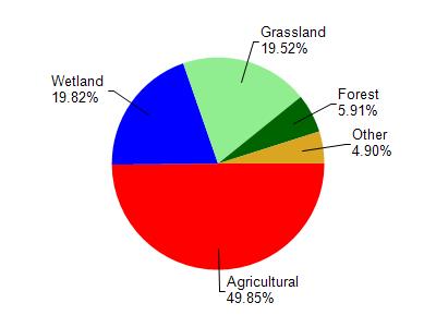
Forestville Flowage is located in the Ahnapee River watershed which is 135.58 mi². Land use in the watershed is primarily agricultural (49.80%), wetland (19.80%) and a mix of grassland (19.50%) and other uses (10.80%). This watershed has 189.28 stream miles, 5,768.81 lake acres and 15,037.67 wetland acres.
Nonpoint Source Characteristics
This watershed is ranked High for runoff impacts on streams, Not Ranked for runoff impacts on lakes and High for runoff impacts on groundwater and therefore has an overall rank of High. This value can be used in ranking the watershed or individual waterbodies for grant funding under state and county programs.However, all waters are affected by diffuse pollutant sources regardless of initial water quality. Applications for specific runoff projects under state or county grant programs may be pursued. For more information, go to surface water program grants.
Hydrological
This watershed is 50.00% impervious.