Waupaca
No
No
No
Fish and Aquatic Life
Overview
Iola Lake (Iola Millpond), in the South Branch Little Wolf River Watershed, is a 220.43 acre lake that falls in Waupaca County. This lake is managed for fishing and swimming and is currently not considered impaired.
Date 2011
Author Aquatic Biologist
Historical Description
Source: 1971, Surface Water Resources of Waupaca County Iola Millpond, T24N, R11E, Sections 26, 35. Surface Acres = 205.9, S.D.F. = 2.36, Maximum Depth = 11 feet.
This hard water impoundment is fed by Mack (Brown) Creek, and two unnamed small feeder streams. The outlet stream is the South Branch Little Wolf River. Water levels are maintained by two dams, one 6 feet high, the other 5 feet high. The water is light brown in color. Northern pike, largemouth bass, bluegill, black crappie, green sunfish, brown trout, bullheads, and white sucker are the most important species present. Shallow water and dense aquatic vegetation limit boating opportunities on this impoundment. An excellent waterfowl marsh exists on the upper reaches of the impoundment. Mallards and bluewing teal use the area for nesting. Hunting is not allowed in that portion of the pond lying within the Village of Iola. Developments consist of one boat livery, two farms, and 15 dwellings. Additional cottages will probably be built because much of the upland around the impoundment has recently been platted. Access is available from a village park located on the south shore. Effluent from several septic tanks and from municipal storm sewers enters the pond contributing to its enrichment. Cattle are pastured along portions of the shore. Iola Millpond is noted for its fine fishing.
Date 1971
Author Surface Water Inventory Of Wisconsin
Condition
Wisconsin has over 84,000 miles of streams, 15,000 lakes and milllions of acres of wetlands. Assessing the condition of this vast amount of water is challenging. The state's water monitoring program uses a media-based, cross-program approach to analyze water condition. An updated monitoring strategy (2015-2020) is now available. Compliance with Clean Water Act fishable, swimmable standards are located in the Executive Summary of Water Condition in 2018. See also the 'monitoring and projects' tab.
Reports
Recommendations
Lake Management Plan Implementation
Review existing data on lake and watershed to define data gaps. Initiate public involvement/information program. Water quality monitoring. Event-related nonpoint source runoff monitoring. Macrophyte survey. Identification of sediment loading and sources of sedimentation. Base map of lake and watershed preparation.
Drawdown of Water
Iola Millpond Drawdown
Management Goals
Wisconsin's Water Quality Standards provide qualitative and quantitative goals for waters that are protective of Fishable, Swimmable conditions [Learn more]. Waters that do not meet water quality standards are considered impaired and restoration actions are planned and carried out until the water is once again fishable and swimmable
Management goals can include creation or implementation of a Total Maximum Daily Load analysis, a Nine Key Element Plan, or other restoration work, education and outreach and more. If specific recommendations exist for this water, they will be displayed below online.
Monitoring
Monitoring the condition of a river, stream, or lake includes gathering physical, chemical, biological, and habitat data. Comprehensive studies often gather all these parameters in great detail, while lighter assessment events will involve sampling physical, chemical and biological data such as macroinvertebrates. Aquatic macroinvertebrates and fish communities integrate watershed or catchment condition, providing great insight into overall ecosystem health. Chemical and habitat parameters tell researchers more about human induced problems including contaminated runoff, point source dischargers, or habitat issues that foster or limit the potential of aquatic communities to thrive in a given area. Wisconsin's Water Monitoring Strategy was recenty updated.
Grants and Management Projects
Monitoring Projects
| WBIC | Official Waterbody Name | Station ID | Station Name | Earliest Fieldwork Date | Latest Fieldwork Date | View Station | View Data |
|---|
| 278800 | Iola Lake | 10007352 | Iola Lake | 7/27/1999 | 7/13/2023 | Map | Data |
| 278800 | Iola Lake | 10018113 | Iola Lake -- Access | | | Map | Data |
| 278800 | Iola Lake | 10050832 | Iola Lake - NE off Valley Lane | 6/4/2018 | 6/4/2018 | Map | Data |
| 278800 | Iola Lake | 10059483 | Frogner Island, Iola Millpond | 6/28/2023 | 6/28/2023 | Map | Data |
| 278800 | Iola Lake | 693107 | Iola Lake - Deep Hole Waupaca Co | 9/17/1992 | 8/22/2023 | Map | Data |
| 278800 | Iola Lake | 10018243 | Iola Lake -- Access | 9/27/2008 | 9/27/2008 | Map | Data |
| 278800 | Iola Lake | 10050833 | Iola Lake - SE off Valley Lane | 6/4/2018 | 6/4/2018 | Map | Data |
|
Watershed Characteristics
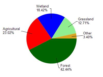
Iola Lake is located in the South Branch Little Wolf River watershed which is 160.29 mi². Land use in the watershed is primarily forest (42.40%), agricultural (23%) and a mix of wetland (18.40%) and other uses (16.10%). This watershed has 166.00 stream miles, 2,070.64 lake acres and 19,091.22 wetland acres.
Nonpoint Source Characteristics
This watershed is ranked Low for runoff impacts on streams, High for runoff impacts on lakes and High for runoff impacts on groundwater and therefore has an overall rank of High. This value can be used in ranking the watershed or individual waterbodies for grant funding under state and county programs.However, all waters are affected by diffuse pollutant sources regardless of initial water quality. Applications for specific runoff projects under state or county grant programs may be pursued. For more information, go to surface water program grants.