Langlade
No
Yes
No
Fish and Aquatic Life
Overview
Post Lake, in the Upper Wolf River and Post Lake Watershed, is a 378.83 acre lake that falls in Langlade County. This lake is an outstanding/exceptional resource water under NR102 under the Fisheries Program. This lake is managed for fishing and swimming and is currently not considered impaired.
Date 2011
Author Aquatic Biologist
Historical Description
Source: 1977, Surface Water Resources of Langlade County Lower Post Lake T-34-N, R-11-E, Sec. 15, Surface Acres = 377.0, Maximum Depth = 9 feet, Secchi Disk greater than 9 feet.
A medium hard water drainage lake having alkaline, clear water of moderate transparency. The immediate shoreline is predominantly upland (75%) of hardwoods with the remainder being wetland. The littoral materials are composed of muck (55%), sand (39%), and gravel (6%). The lake basin supports a dense growth of submergent aquatic vegetation. The fish population consists of muskellunge, northern pike, walleye, largemouth bass, and panfish. The lake has a history of winterkill and algae blooms. Inlet water to the lake includes the Wolf River, Mud Creek, and two unnamed lakes, Lake 23- 14 and Lake 23-15. The outlet stream continues as the Wolf River. A water control structure is located at the outlet, having a ten- foot head, and is controlled by the Town of Elcho. Shoreline developments include 149 dwellings, two resorts and a private campground. Public access without parking is available adjacent to the dam site. Of the 8.40 miles of shoreline, 0.48 mile is public and in Langlade County ownership Public access via the outlet from the public landing on Upper Post Lake is also available.
Date 1977
Author Surface Water Inventory Of Wisconsin
General Condition
Lower Post Lake (397100) was assessed during the 2016 listing cycle; total phosphorus sample data were clearly below 2016 WisCALM listing thresholds for Recreation use and Fish and Aquatic Life use. Chlorophyll sample data were clearly below FAL use listing thresholds and did not exceed REC listing thresholds. This water is meeting these designated uses and is not considered impaired.
Date 2015
Author Ashley Beranek
Condition
Wisconsin has over 84,000 miles of streams, 15,000 lakes and milllions of acres of wetlands. Assessing the condition of this vast amount of water is challenging. The state's water monitoring program uses a media-based, cross-program approach to analyze water condition. An updated monitoring strategy (2015-2020) is now available. Compliance with Clean Water Act fishable, swimmable standards are located in the Executive Summary of Water Condition in 2018. See also the 'monitoring and projects' tab.
Reports
Recommendations
Lake Management Plan Development
This project will implement one of the recommendations of the Post Lakes Management Plan. The project will include development of a long-term project to support and encourage shoreland buffers and restoration of shoreland properties. The project also includes the restoration of 6 lots as education demonstration sites.
Management Goals
Wisconsin's Water Quality Standards provide qualitative and quantitative goals for waters that are protective of Fishable, Swimmable conditions [Learn more]. Waters that do not meet water quality standards are considered impaired and restoration actions are planned and carried out until the water is once again fishable and swimmable
Management goals can include creation or implementation of a Total Maximum Daily Load analysis, a Nine Key Element Plan, or other restoration work, education and outreach and more. If specific recommendations exist for this water, they will be displayed below online.
Monitoring
Monitoring the condition of a river, stream, or lake includes gathering physical, chemical, biological, and habitat data. Comprehensive studies often gather all these parameters in great detail, while lighter assessment events will involve sampling physical, chemical and biological data such as macroinvertebrates. Aquatic macroinvertebrates and fish communities integrate watershed or catchment condition, providing great insight into overall ecosystem health. Chemical and habitat parameters tell researchers more about human induced problems including contaminated runoff, point source dischargers, or habitat issues that foster or limit the potential of aquatic communities to thrive in a given area. Wisconsin's Water Monitoring Strategy was recenty updated.
Grants and Management Projects
Monitoring Projects
| WBIC | Official Waterbody Name | Station ID | Station Name | Earliest Fieldwork Date | Latest Fieldwork Date | View Station | View Data |
|---|
| 397100 | Lower Post Lake | 10003156 | Post Lake (Lower) | 9/30/1998 | 9/21/2017 | Map | Data |
| 397100 | Lower Post Lake | 10018624 | Lower Post Lake -- Access at Isle Of Pines Nr Peterson Point Rd | 5/26/2008 | 8/15/2025 | Map | Data |
| 397100 | Lower Post Lake | 10020559 | Lower Post Lake - North Basin | | | Map | Data |
| 397100 | Lower Post Lake | 343148 | Lower Post Lake - Deep Hole | 5/10/1986 | 5/13/2019 | Map | Data |
|
Watershed Characteristics
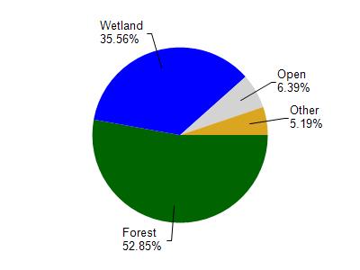
Lower Post Lake is located in the Upper Wolf River and Post Lake watershed which is 203.31 mi². Land use in the watershed is primarily forest (52.90%), wetland (35.60%) and a mix of open (6.40%) and other uses (5.20%). This watershed has 202.70 stream miles, 7,524.17 lake acres and 32,034.92 wetland acres.
Nonpoint Source Characteristics
This watershed is ranked Not Ranked for runoff impacts on streams, Not Ranked for runoff impacts on lakes and Low for runoff impacts on groundwater and therefore has an overall rank of Low. This value can be used in ranking the watershed or individual waterbodies for grant funding under state and county programs.However, all waters are affected by diffuse pollutant sources regardless of initial water quality. Applications for specific runoff projects under state or county grant programs may be pursued. For more information, go to surface water program grants.