")
6.99 Miles
0 - 6.99
Macroinvertebrate, Cool-Cold Headwater, Cool-Warm Headwater
2026
Poor
Degraded Biological Community, Degraded Habitat, Chronic Aquatic Toxicity
Chloride, Total Phosphorus, Sediment/Total Suspended Solids
Calumet, Outagamie
No
No
Yes
Fish and Aquatic Life
Overview
Garners Creek is a 7-mile long tributary stream to the Fox River. Land use in the watershed is predominantly urban with some limited areas of agricultural lands isolated near the headwaters. The urbanization along the banks of Garners Creek has significantly altered the hydrology and these impacts are severely limiting the aquatic life in this stream. The fish community is dominated by species tolerant to environmental degradation and the FIBI rated from poor to fair. The habitat scores rated fair to good. The stream is highly entrenched in areas and severe bank erosion exists due to the flashy flow regime of this stream. Habitat scores are bolstered in areas where bank stabilization measures have been installed however these small piece by piece projects have incurred cumulative impacts to downstream reaches where stabilization measures are absent. Total Phosphorous concentrations exceed the State?s water quality criteria for phosphorous and high suspended solids load continue to impair this stream
Date 2020
Author Andrew Hudak
Historical Description
Garners Creek, is a 5-mile stream with poor water quality. During rain events the creek flow increases and recedes very fast. Stream flows were practically non-existent in July and August (flows approximately 0.2 cfs). A very brief fish survey was conducted in August 1992, in a stretch of creek near Hartjes Road. One large pollution tolerant rough fish (carp) was found in a deep pool area and one tolerant sport fish (green sunfish) was present. The most abundant fish present were tolerant forage species, such as emerald shiners, white suckers, bluntnose minnows and creek chubs. Garners Creek receives a considerable amount of suspended solids and bacteria during runoff events. Dissolved phosphorus and chlorides were slightly elevated on several occasions. Stream habitat was rated fair to poor. Streambank erosion and failure is common with frequent slumping and raw areas form bank flooding. Gravel, rubble and other stable habitat lie under a layer of clay sediment and many of the pools are filled in. Filamentous algae covers the rocks and bottom substrate in shallow exposed areas. In the rural portion of the watershed, row crops border streambanks. Garners Creek travels a short distance through an urban area before entering the Fox River (Gansberg 1995). Additional water quality data (D.O. and temperature data) should be collected from Garners Creek to determine if there are any water quality standards violations and if it should be placed on the 303(d) list of impaired waterbodies. The next update of 303(d) impaired waterbodies is scheduled for the year 2000.
Bougie, Cheryl A. 1999. Lower Fox River Basin Water Quality Management Plan. Public Review Draft. Wisconsin Department of Natural Resources, Madison, WI.
Date 1999
Author Cheryl Bougie
Impaired Waters
Garners Creek was assessed during the 2018 and 2016 assessment cycle. Total phosphorus sample data clearly exceeded the 2018 WisCALM condition thresholds for Fish and Aquatic Life use water quality standards, indicating that the water should be on the impaired waters list.
Biological data also indicated impairment (i.e. at least one macroinvertebrate or fish Index of Biotic Integrity (IBI) scored "poor" condition). This water is not meeting this designated use and is considered impaired from a degraded biological community with total phosphorus as a pollutant, adding to the existing listing of total suspended solids from 2008 and for chloride chronic toxicity, which was listed in 2016.
Date 2017
Author Amanda Smith
Condition
Wisconsin has over 84,000 miles of streams, 15,000 lakes and milllions of acres of wetlands. Assessing the condition of this vast amount of water is challenging. The state's water monitoring program uses a media-based, cross-program approach to analyze water condition. An updated monitoring strategy (2015-2020) is now available. Compliance with Clean Water Act fishable, swimmable standards are located in the Executive Summary of Water Condition in 2018. See also the 'monitoring and projects' tab.
Reports
Recommendations
Stormwater Planning, Implementation
This project is an installation of nonpoint source best management practices to contribute to the restoration of Wisconsin?s waters and was funded by the 319 grant. Specifically, the grantee will ost-share storm water plan modifications designed to meet the wasteload allocations of the Lower Fox River TMDL for the participating communities within the Garners Creek watershed, including the Garners Creek Storm Water Utility, town of Buchanan, Village of Combined Locks, and town of Harrison.
Navigability Determination
NE SW S32 T21N R18E; Garners Creek, trib;
Navigability Determination
20N 18E S4; Lake Winnebago, unnamed;
Management Goals
Wisconsin's Water Quality Standards provide qualitative and quantitative goals for waters that are protective of Fishable, Swimmable conditions [Learn more]. Waters that do not meet water quality standards are considered impaired and restoration actions are planned and carried out until the water is once again fishable and swimmable
Management goals can include creation or implementation of a Total Maximum Daily Load analysis, a Nine Key Element Plan, or other restoration work, education and outreach and more. If specific recommendations exist for this water, they will be displayed below online.
Monitoring
Monitoring the condition of a river, stream, or lake includes gathering physical, chemical, biological, and habitat data. Comprehensive studies often gather all these parameters in great detail, while lighter assessment events will involve sampling physical, chemical and biological data such as macroinvertebrates. Aquatic macroinvertebrates and fish communities integrate watershed or catchment condition, providing great insight into overall ecosystem health. Chemical and habitat parameters tell researchers more about human induced problems including contaminated runoff, point source dischargers, or habitat issues that foster or limit the potential of aquatic communities to thrive in a given area. Wisconsin's Water Monitoring Strategy was recenty updated.
Grants and Management Projects
Monitoring Projects
| WBIC | Official Waterbody Name | Station ID | Station Name | Earliest Fieldwork Date | Latest Fieldwork Date | View Station | View Data |
|---|
| 127700 | Garners Creek | 10047153 | Garners Creek US Park Street | 1/1/2015 | 7/14/2016 | Map | Data |
| 127700 | Garners Creek | 453277 | Garners Creek at Park | 5/20/2004 | 9/9/2014 | Map | Data |
| 127700 | Garners Creek | 10043028 | Garner's Creek ds of CTH Z | 1/1/2015 | 6/15/2026 | Map | Data |
| 127700 | Garners Creek | 10047162 | Garners Creek 1000 meters US CTH N | 1/1/2015 | 10/4/2016 | Map | Data |
| 127700 | Garners Creek | 10016542 | Garners Creek - Brookhaven Dr. - 500 Feet Down-Stream Just East Of Cth N And North Ofcth Ce | 4/2/1992 | 10/26/2016 | Map | Data |
| 127700 | Garners Creek | 10047161 | Garners Creek 850 meters US CTH N | 1/1/2015 | 10/4/2016 | Map | Data |
| 127700 | Garners Creek | 10015579 | Garners Creek- Upstream Of K | | | Map | Data |
| 127700 | Garners Creek | 10015871 | Garners Creek - Hartjes Rd. | 5/22/1997 | 10/20/1997 | Map | Data |
| 127700 | Garners Creek | 10047160 | Garners Creek 375 meters US CTH N | 1/1/2015 | 10/4/2016 | Map | Data |
|
Watershed Characteristics
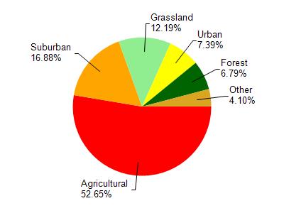
Garners Creek is located in the Plum and Kankapot Creeks watershed which is 84.04 mi². Land use in the watershed is primarily agricultural (52.70%), suburban (16.90%) and a mix of grassland (12.20%) and other uses (18.30%). This watershed has 193.77 stream miles, 39.36 lake acres and 1,129.50 wetland acres.
Nonpoint Source Characteristics
This watershed is ranked High for runoff impacts on streams, Not Available for runoff impacts on lakes and High for runoff impacts on groundwater and therefore has an overall rank of High. This value can be used in ranking the watershed or individual waterbodies for grant funding under state and county programs.However, all waters are affected by diffuse pollutant sources regardless of initial water quality. Applications for specific runoff projects under state or county grant programs may be pursued. For more information, go to surface water program grants.
Garners Creek is considered a Macroinvertebrate, Cool-Cold Headwater, Cool-Warm Headwater under the state's Natural Community Determinations.
Natural communities (stream and lake natural communities) represent model results and DNR staff valiation processes that confirm or update predicted conditions based on flow and temperature modeling from historic and current landscape features and related variables. Predicated flow and temperatures for waters are associated predicated fish assemblages (communities). Biologists evaluate the model results against current survey data to determine if the modeled results are corect and whether biological indicators show water quaity degradation. This analysis is a core component of the state's resource management framework. Wisconsin's Riverine Natural Communities.
Cool (Warm-Transition) Headwaters are small, sometimes intermittent streams with cool to warm summer temperatures. Coldwater fishes are uncommon to absent, transitional fishes are abundant to common, and warm water fishes are common to uncommon. Headwater species are abundant to common, mainstem species are common to absent, and river species are absent.
Cool (Cold-Transition) Headwaters are small, usually perennial streams with cold to cool summer temperatures. Coldwater fishes are common to uncommon (<10 per 100 m), transitional fishes are abundant to common, and warm water fishes are uncommon to absent. Headwater species are abundant to common, mainstem species are common to absent, and river species are absent.