Dane
No
No
Yes
Fish and Aquatic Life
Overview
Pheasant Branch Creek is 7-mile-long stream that drains 22.7 square miles of west-central Dane County. It enters Lake Mendota from the west. The stream's South Fork is intermittent and flows north from its headwater near Mineral Point Road. It drains the rapidly urbanizing west side of Madison and the city of Middleton. The North Fork drainage area is predominately agricultural until its confluence with the South Fork at the western edge of the city of Middleton and Highway 12. Much of the North Fork has been channelized and straightened in the segment west of the city of Middleton. The stream is still rapidly eroding a channel through the terminal moraine that once blocked its outlet to Mendota. Cultivation of land draining to the creek, ditching, straightening, and urbanization have all increased the peak flows through the downstream section, accelerating channel and bank erosion (WDNR 1981). In addition, much of the historic wetland along the creek has been drained.
Downstream of the confluence of the North and South forks, the stream passes through the city of Middleton and has a fairly steep gradient until it enters Pheasant Branch Marsh just upstream of its mouth. Despite extensive rip-rapping before 1991 to reduce severe channel erosion in the city of Middleton, streambank erosion continued. Given the extensive and rapid urbanization of both the North and South Fork areas, channel erosion will likely remain a problem.
Increased urbanization delivers increasing amounts of sediment to Pheasant Branch Marsh and Lake Mendota, requiring occasional dredging of the mouth of the stream. Stormwater management structures already installed in the Madison portion of the South Fork drainage area may not be adequate to handle future growth. The rapidity of urban development, particularly west of the Beltline Highway, exceeds the ability of the channel and these structures to adequately handle the runoff and sediment loads. For example, sediment-laden stormwater from a spring 1989 storm flowed out of the channel, flooding a jogging path and bypassing two wet detention basins. After the same storm, Pheasant Branch Creek at the Highway 12 bridge carried a heavy sediment load from agricultural erosion in the North Fork drainage area, construction site erosion from the South Fork drainage area, and construction site erosion from highway construction in Middleton. As this area continues to develop, peak flows will increase, causing more channel and streambank erosion.
Rock River Water Quality Management Plan, Lower Rock River Appendix. WT-668-2002. South Central Region, WDNR.
Date 2002
Author Aquatic Biologist
Overview
Pheasant Branch Creek begins in the glacial moraine area of the Town of Springfield (T8N, R8E, Sec. 34) and flows south and east through the City of Mlddleton, entering Lake Mendota on its western lobe. A south branch, mostly ditched and draining an urban area, forms Pleasant Branch above Highway 12. Much of the creek has been straightened and most adjacent wetlands have been drained for agricultural and residential development. One important wetland that remains largely intact is the 311-acre Pheasant Branch Marsh. Located near the mouth of the creek, it offers spawning habitat for northern pike. The worst problem facing Pheasant Branch Creek is a poor base flow and excessive peak runoff that created a high sediment load which threatens the marsh and contributes to lake sediments.
The main source of sediment is the erosion of unconsolidated, unstable glacial deposits at the headwaters (Dane Cty. Reg. Plann. Comm. 1979a). This natural erosion is exacerbated by local land development and could be slowed through improved soil conservation measures. Many farmers owning land along the banks have cooperated in innovative soil and water conservation programs. Other water quality problems include moderately high alkalinity and fertility in addition to unusually high levels of chloride for a creek that receives no municipal or industrial discharges. However, it does collect urban runoff as it flows through Middleton. The natural, steep-sided configuration of the creek channel and its watershed are conducive to spring flooding. The creek has a low base flow in its upper portions where it supports forage fish. A diverse warm water fishery is found downstream where the creek joins Lake Mendota. Waterfowl use the Pheasant Branch Marsh for nesting, and as a wintering area. Access is available at four road crossings and over Middleton public lands near the headwaters.
Fish species: bowfin. northern pike, northern pike x muskie, common carp, southern redbelly dace, fathead minnow, blacknose dace, creek chub, white sucker. bullhead (unsp.), brook stickleback, crappie (unsp.), pumpkinseed, blueglll, largemouth bass, and walleye.
Pheasant Branch Creek -T7E, R8E, Sec. 12, Surface acres = 4, Length = 7 miles, Stream order = I, Gradient = 19.7 ft/mile, Base discharge = 1.6 cfs.
From: Day, Elizabeth A.; Grzebieniak, Gayle P.; Osterby, Kurt M.; and Brynildson, Clifford L., 1985. Lake and Stream Classification Project. Surface Water Resources of Dane County, Wisconsin Department of Natural Resources, Madison, WI.
Date 1985
Author Aquatic Biologist
Historical Description
In 1995, the city of Middleton began a channel manipulation project on Pheasant Branch Creek to relocate the South Fork of the creek from the city limits to the confluence with the North Fork. This work includes construction of a detention pond. The project's goals are to reduce the 100-year floodplain and improve flood control through constructing detention ponds. The detention pond is a 22-acre sedimentation basin that includes a filtering system to reduce sediment influx into the pond during the first flush of a storm. The system is designed with gabions that run perpendicular to the flow to prevent streambank erosion and a filtering system to trap nutrients, sediment and heavy metals before they enter the pond and are washed downstream to the river. Overall, planners hope the project will reduce streambank erosion, in- stream sedimentation, and peak flows following heavy storms. While this project has positive aspects, the stormwater control dam will likely increase water temperatures in the downstream reach and prevent fish migration (WDNR 1996b).
In 1994, Dane County purchased more than 160 acres to add to the existing Pheasant Branch Creek Resource Protection Area, including springs that feed the creek, one of which produces over 900 gallons per minute (WDNR 1996b). WDNR fish managers are managing 60 of those acres to protect and enhance northern pike habitat; northern pike from Lake Mendota use this wetland area for spawning.
The Pheasant Branch fishery consists of tolerant forage fish above the Pheasant Branch Marsh (Hwy 12). From the marsh to Lake Mendota, a diverse warm water fishery exists. Northern pike have used the marsh as a spawning site but sediment carried by the stream is impairing this fishery use (WDNR 1996b).
Date 2002
Author Aquatic Biologist
Impaired Waters
The 2018 assessments of Pheasant Branch (miles 1-9.09) showed continued impairment by phosphorus; new total phosphorus sample data overwhelmingly exceeded the 2018 WisCALM listing thresholds for the Fish and Aquatic Life use and biological impairment was observed (i.e. at least onefish Index of Biotic Integrity (IBI) scored in the poor condition category). Based on the most updated information, no change in the existing impaired waters listing was needed.
Date 2017
Author Ashley Beranek
Impaired Waters
The 2018 assessments of Pheasant Branch (miles 0-1) showed continued impairment by phosphorus; new total phosphorus sample data exceeded the 2018 WisCALM listing criteria for the Fish and Aquatic Life use. However, available biological data did not indicate impairment (i.e. no macroinvertebrate or fish Index of Biotic Integrity (IBI) scored in the "poor" condition category). Based on the most updated information, no change in the existing impaired waters listing was needed. The 2018 assessments showed continued impairment by chloride; new chloride sample data exceeded the 2018 WisCALM listing criteria for the Fish and Aquatic Life use. Based on the most updated information, no change in the existing impaired waters listing was needed.
Date 2017
Author Ashley Beranek
Impaired Waters
This segment of Pheasant Branch (mile 1 to headwaters) has been on the state's 303(d) impaired waters list since 1998.
This water was assessed during the 2012 listing cycle, and total phosphorus sample data exceed 2012 WisCALM listing criteria for the fish and aquatic life use; however, available biological data do not indicate impairment (i.e. no macroinvertebrate or fish Index of Biotic Integrity (IBI) scored in the poor condition category). TMDL is now approved.
This water was assessed during the 2014 listing cycle; total phosphorus sample data exceed 2014 WisCALM listing criteria for the Fish and Aquatic Life use and biological impairment was observed (i.e. at least one macroinvertebrate or fish Index of Biotic Integrity (IBI) scored in the poor condition category).
This water was assessed during the 2016 listing cycle; chloride sample data exceeded 2016 WisCALM chronic and acute listing criteria for the Fish and Aquatic Life use. Total phosphorus sample data overwhelmingly exceed 2016 WisCALM listing thresholds for the Fish and Aquatic Life use, however, available biological data do not indicate impairment (i.e. no macroinvertebrate or fish Index of Biotic Integrity (IBI) scored in the "poor" condition category).
Date 2015
Author Aaron Larson
Impaired Waters
This segment of Pheasant Branch (mouth to mile 1) has been on the state's 303(d) impaired waters list since 1998. This water was assessed during the 2012 listing cycle, and total phosphorus sample data exceed 2012 WisCALM listing criteria for the fish and aquatic life use; however, available biological data do not indicate impairment (i.e. no macroinvertebrate or fish Index of Biotic Integrity (IBI) scored in the poor condition category). The TMDL is now approved.
This water was assessed during the 2016 listing cycle and chloride sample data exceeded 2016 WisCALM chronic listing criteria for the Fish and Aquatic Life use.
Date 2015
Author Aaron Larson
Condition
Wisconsin has over 84,000 miles of streams, 15,000 lakes and milllions of acres of wetlands. Assessing the condition of this vast amount of water is challenging. The state's water monitoring program uses a media-based, cross-program approach to analyze water condition. An updated monitoring strategy (2015-2020) is now available. Compliance with Clean Water Act fishable, swimmable standards are located in the Executive Summary of Water Condition in 2018. See also the 'monitoring and projects' tab.
Reports
Recommendations
Aquatic Invasive Species Plan
The Friends of Pheasant Branch Conservancy, Inc., proposes to develop a multi-phase, multi-year plan for controlling AIS plants in the wetlands of the conservancy, especially around the big springs that feed the creek. Reed canary grass, hybrid cattail and watercress are outcompeting native plant species, and these invasives require a comprehensive, long-term strategy to reduce their dominance and encourage competition of the natives. Plant inventories, soil samples and water data will be gathered in order to prepare the plan. Signage, newsletter articles and guided field trips will be used to engage and educate the public at all steps in the plan. The final report will consist of electronic and hard copy of all raw data, plus the final plan, and a description of all public outreach efforts made.
Monitor Water Quality or Sediment
The Friends of the Pheasant Branch will sponsor a monitoring project on a tributary of the Pheasant Branch by collecting grab samples at 5 sites on the tributary during or immediately after snowmelt or larger rainfall runoff events. The project will evaluate the effectiveness of the recently dredged ponds and combined conservation practices in reducing sediment and nutrient loads entering Pheasant Branch Marsh and continue to collect flow data from the springs to establish a data base to help in evaluating future changes possibly caused by well pumping or land use. Project Deliverables include - 1. Electronic or weblink to Flow, Kjeldahl nitrogen, total phospherous and total sediment sampling results of 4 events in FY 2011 and 3 events in FY2012 at 5 locations. 2. Electronic copy of Conservation practices effectiveness analysis. 3. Electronic copy or weblink of Fredrick Springs flow measurements. 4. Electronic or hard copy of brochure or fact sheet. 5. Electronic copy newsletter containing analysis results. 6. Public meeting agenda with date and location and attendance list for meeting presenting data.
Monitor Watershed (Status,Sources,Impairments)
The goals of this grant are to monitor the effectiveness of sediment traps and management practices, use the Friends of Pheasant Branch to provide at least $3,320 in in-kind consulting services, expand the educational resources of the "Kids for the Earth" Program, and conduct four family events at the conservancy to highlight the special resources of the area.
Educate and engage residents
The Friends of Pheasant Branch will expand their "Kids for the Earth" curriculum development program, provide seed money for the development of a second focal project, monitor water quality in order to assess the effectiveness of sediment traps on the Pheasant Branch, and support newsletter production. A full description of the project scope and deliverables is available in the grant application which is part of this agreement. The Friends will disseminate information to the public as described in the grant application.
Educate and engage residents
The Friends of Pheasant Branch will attempt to build members within their organization. They will raise funds to support a paid director, expand education programs and outreach, along with implementing a master plan for conservancy and identifying watershed restoration projects.
Watershed Mapping or Assessment
The Friends of the Pheasant Branch will hire a part-time program coodinator for one year. This will move the organization from an all-volunteer grassroots organization to one with a paid staff. It will support and expand the ability of the Board of Directors and volunteer members to meet serious environmental challenges in the watershed.
Nine Key Element Plan
Sixmile-Pheasant Branch PWS Plan - Nine Key Element Plan - The Sixmile-Pheasant Branch Priority Watershed Project plan assesses the nonpoint sources of pollution in the Sixmile-Pheasant Branch Watershed and guides the implementation of nonpoint source control measures. The purpose of this project is to reduce the amount of pollutants originating from nonpoint sources that reach surface water and groundwater within the Sixmile-Pheasant Branch Priority Watershed Project area.
Management Goals
Wisconsin's Water Quality Standards provide qualitative and quantitative goals for waters that are protective of Fishable, Swimmable conditions [Learn more]. Waters that do not meet water quality standards are considered impaired and restoration actions are planned and carried out until the water is once again fishable and swimmable
Management goals can include creation or implementation of a Total Maximum Daily Load analysis, a Nine Key Element Plan, or other restoration work, education and outreach and more. If specific recommendations exist for this water, they will be displayed below online.
Monitoring
Monitoring the condition of a river, stream, or lake includes gathering physical, chemical, biological, and habitat data. Comprehensive studies often gather all these parameters in great detail, while lighter assessment events will involve sampling physical, chemical and biological data such as macroinvertebrates. Aquatic macroinvertebrates and fish communities integrate watershed or catchment condition, providing great insight into overall ecosystem health. Chemical and habitat parameters tell researchers more about human induced problems including contaminated runoff, point source dischargers, or habitat issues that foster or limit the potential of aquatic communities to thrive in a given area. Wisconsin's Water Monitoring Strategy was recenty updated.
Grants and Management Projects
Monitoring Projects
| WBIC | Official Waterbody Name | Station ID | Station Name | Earliest Fieldwork Date | Latest Fieldwork Date | View Station | View Data |
|---|
| 805900 | Pheasant Branch | 133343 | Pheasant Branch - 100 Yds Upstm Hy 12 | 6/20/1990 | 5/13/2015 | Map | Data |
| 805900 | Pheasant Branch | 10032762 | North Branch Pheasant Branch downstream of pond at Deming Way | 2/14/2011 | 1/1/2015 | Map | Data |
| 805900 | Pheasant Branch | 133554 | Pheasant Branch at Cth K | | | Map | Data |
| 805900 | Pheasant Branch | 10045646 | Phragmites occurrence 1338 - Pheasant Branch | | | Map | Data |
| 805900 | Pheasant Branch | 133345 | Pheasant Branch - 50 Yds Belw High Rd | 6/20/1990 | 8/9/2025 | Map | Data |
| 805900 | Pheasant Branch | 10033405 | Pheasant Branch downstream of Century Ave at foot bridge | 2/14/2011 | 4/21/2015 | Map | Data |
| 805900 | Pheasant Branch | 133315 | Pheasant Branch at Ush 12 In Middleton WI | 5/1/1980 | 5/27/2026 | Map | Data |
| 805900 | Pheasant Branch | 133316 | Pheasant Branch at Airport Road near Middleton WI | 5/1/1980 | 5/18/2026 | Map | Data |
| 805900 | Pheasant Branch | 10010435 | Pheasant Br - Pheasant Branch 20m Upstream Park Street | 1/1/2015 | 10/13/2015 | Map | Data |
| 805900 | Pheasant Branch | 10029790 | Pheasant Branch at Middleton High School | 5/24/2002 | 10/15/2025 | Map | Data |
| 805900 | Pheasant Branch | 10033404 | North Branch Pheasant Branch up from confluence with pond off of bike path | 2/14/2011 | 1/1/2015 | Map | Data |
| 5034992 | Unnamed | 10012026 | Tributary Of Pheasant Branch At Schneider Rd | | | Map | Data |
| 805900 | Pheasant Branch | 133553 | Pheasant Branch at Schneider Rd | 11/16/1991 | 3/1/2026 | Map | Data |
| 805900 | Pheasant Branch | 133400 | Pheasant Branch at Middleton WI | | | Map | Data |
|
Watershed Characteristics
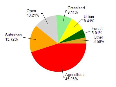
Pheasant Branch is located in the Six Mile and Pheasant Branch Creeks watershed which is 119.45 mi². Land use in the watershed is primarily agricultural (45%), suburban (15.70%) and a mix of open (13.20%) and other uses (26.00%). This watershed has 145.61 stream miles, 9,959.08 lake acres and 2,759.80 wetland acres.
Nonpoint Source Characteristics
This watershed is ranked Not Available for runoff impacts on streams, Not Available for runoff impacts on lakes and High for runoff impacts on groundwater and therefore has an overall rank of High. This value can be used in ranking the watershed or individual waterbodies for grant funding under state and county programs.However, all waters are affected by diffuse pollutant sources regardless of initial water quality. Applications for specific runoff projects under state or county grant programs may be pursued. For more information, go to surface water program grants.