Dane, Jefferson, Rock
No
No
Yes
Fish and Aquatic Life
Overview
A large shallow impoundment of the Rock River, Lake Koshkonong exhibits the same water quality problems as other impoundments in southern Wisconsin but on a much larger scale. The lake was originally a shallow and deep-water marsh; a dam constructed in 1850 created a shallow lake. The dam was rebuilt in 1917, raising the lake level an additional two feet. The lake is a major stop-over for migratory waterfowl and was renowned for waterfowl hunting. The drainage area above the lake encompasses 2,640 square miles.
Tremendous sediment and nutrient loads from the Rock River, Koshkonong Creek and other tributaries enter the lake annually. These loads are primarily from agricultural and some urban sources. In addition, shoreline erosion is severe on the lake. Failing septic systems were a problem in the past but the creation of a sanitary district around a portion of the lake has reduced the impact of this source on water quality. Carp are a widespread problem despite a large commercial carp fishery; the carp destroy habitat and increase the lake's existing level of turbidity. As a result, severe nuisance growth of algae and algae blooms are common, often resulting in fish kills.
The lake's shallow depth combined with its long fetch--the distance the wind blows across it uninterrupted-- causes serious shoreline erosion during major storms. All these conditions combined adversely affect water quality and the lake's fisheries.
The Indianford Dam, which controls the water level of the lake, is in need of repair. The allocation of repair costs among the counties and towns that border the lake has become a local political issue. One group of property owners wants a higher water level to improve boating while another group wants lower levels to protect and improve wetland habitat.
Date 2002
Author Aquatic Biologist
General Condition
Being a large shallow impoundment of the Rock River, Lake Koshkonong exhibits the same water quality problems as other impoundments in southern Wisconsin but on a much larger scale. The drainage area above the lake encompasses 2,640 square miles. According to DNR water condition data, tremendous sediment and nutrient loads from the Rock River, Koshkonong Creek and other tributaries enter the lake annually. These loads are primarily from agricultural and some urban sources. The lake is included on the WDNR's 303(d) Impaired Waters list. Impairments include low dissolved oxygen, degraded habitat, and turbidity from total phosphorus and sediment/total suspended solids. The lake is included in the Rock River TMDL for phosphorus and sediment reductions. Failing septic systems were a problem in the past but the creation of the sanitary district around a portion of the lake has reduced the impact of this source on water quality.
According to DNR, carp are a widespread problem despite a large commercial carp fishery; the carp destroy habitat and increase the lake's existing level of turbidity. As a result, severe nuisance growth of algae and algae blooms are common, often resulting in fish kills. The lake's shallow depth combined with its long fetch (the distance the wind blows across it uninterrupted) causes serious shoreline erosion during major storms. All these conditions combined adversely affect water quality and the lake's fisheries.
Date 2017
Author Mike Kakuska
Impaired Waters
Lake Koshkonong Lakeland Campground Beach was evaluated for bacteria in the 2022 cycle; E. coli levels were above listing thresholds as outlined in 2022 WisCALM. This beach was added to the 2022 Impaired Waters List.
Date 2022
Author Ashley Beranek
Impaired Waters
The lake is included on the WDNR's 303(d) Impaired Waters list. Impairments include low dissolved oxygen, degraded habitat, and turbidity from total phosphorus and sediment/total suspended solids. The lake is included in the Rock River TMDL for phosphorus and sediment reductions. Failing septic systems were a problem in the past but the creation of the sanitary district around a portion of the lake has reduced the impact of this source on water quality.
Date 2017
Author Mike Kakuska
Condition
Wisconsin has over 84,000 miles of streams, 15,000 lakes and milllions of acres of wetlands. Assessing the condition of this vast amount of water is challenging. The state's water monitoring program uses a media-based, cross-program approach to analyze water condition. An updated monitoring strategy (2015-2020) is now available. Compliance with Clean Water Act fishable, swimmable standards are located in the Executive Summary of Water Condition in 2018. See also the 'monitoring and projects' tab.
Reports
Recommendations
Lake Classification
Dane County Lake Classification-Phase 2: The Phase 1 classification grant classified all county lakes and streams. This grant will take the next step by developing a management program based on the classification.
Lake Classification
Dane County Department of Planning and Development will hire a project staff in order to develop a Lake Classification project, which is seen as the first step toward developing a consistent set of county-wide standards and procedures to protect Dane County Waters.
Lake Classification
Jefferson County Land and Water Conservation Department will undertake a lake classification process. The resulting lake classification system will enable the County and other lake management entities to implement appropriate lake management strategies in a priority -driven and efficient manner. It will result in the protection and restoration of the water quality and natural ecosystems of the lakes in Jefferson County.
Land Acquisition
Jefferson County will acquire the Mimmick property, Sabotka property, and the McEvoy property for lake protection purposes. The preservation of these parcels are for open space and passive recreation use.
Land Acquisition
Jefferson County will acquire for lake protection purposes. The preservation of these parcels are for open space and passive recreation use. Eligible costs include acquisition of the parcel, appraisal fee and preparation of an environmental assessment.
Land Acquisition
Jefferson County will acquire property for lake protection purposes. The preservation of these parcels are for open space and passive recreation use. Eligible costs include acquisition of the parcel, appraisal fee and preparation of an environmental assessment.
Sewer Service Area Planning
Dane County Water Quality Planning updates and amendments.
Management Goals
Wisconsin's Water Quality Standards provide qualitative and quantitative goals for waters that are protective of Fishable, Swimmable conditions [Learn more]. Waters that do not meet water quality standards are considered impaired and restoration actions are planned and carried out until the water is once again fishable and swimmable
Management goals can include creation or implementation of a Total Maximum Daily Load analysis, a Nine Key Element Plan, or other restoration work, education and outreach and more. If specific recommendations exist for this water, they will be displayed below online.
Monitoring
Monitoring the condition of a river, stream, or lake includes gathering physical, chemical, biological, and habitat data. Comprehensive studies often gather all these parameters in great detail, while lighter assessment events will involve sampling physical, chemical and biological data such as macroinvertebrates. Aquatic macroinvertebrates and fish communities integrate watershed or catchment condition, providing great insight into overall ecosystem health. Chemical and habitat parameters tell researchers more about human induced problems including contaminated runoff, point source dischargers, or habitat issues that foster or limit the potential of aquatic communities to thrive in a given area. Wisconsin's Water Monitoring Strategy was recenty updated.
Grants and Management Projects
| Project Name (Click for Details) | Year Started |
|---|
| JEFFERSON CO. PARKS DEPT.: ACQ-Blackhawk Island Acquisition-Mimmick,Sabotka, McEvoy Props | 1995 |
| ROCK-KOSHKONONG LAKE DISTRICT: RES-Crescent Bay Hunt Club Riprap Installation | 2003 |
| ROCK-KOSHKONONG LAKE DISTRICT: Rock-Koshkonong Comprehensive Planning 2003-1 | 2003 |
| JEFFERSON CO LWCD: LCO-Jefferson County Lake Classification | 1999 |
| ROCK-KOSHKONONG LAKE DISTRICT: RES-Duesterbeck Property Riprap-Otter Creek Wetland | 2003 |
| Lake Koshkonong Urban Service Area CARPC | 1995 |
| JEFFERSON COUNTY LCD: HLK-Jefferson County Healthy Lakes Grant 4 | 2020 |
| JEFFERSON CO. PARKS DEPT.: ACQ-Blackhawk Island Acquisition - Gordon, Keller, Zunker Prop. | 1995 |
| DANE COUNTY DEPT. OF PLANNING & DEV: LCO-Dane Cnty Lk & Stream Classification | 2003 |
| ROCK-KOSHKONONG LAKE DISTRICT: RES-Shearer Property Riprap Installation | 2003 |
| DANE COUNTY: State of the Waters' Publication | 2004 |
| DANE COUNTY: Dane County Workshop for Local Resource Groups | 2004 |
| ROCK-KOSHKONONG LAKE DISTRICT: RES-Shackelford Vegetation Restoration | 2003 |
| ROCK-KOSHKONONG LAKE DISTRICT: Lake Koshkonong Management Plan Phase 2 | 2000 |
| ROCK-KOSHKONONG LAKE DISTRICT: Koshkonong WQ Sampling for Comprehensive Planning | 2002 |
| LAKE KOSHKONONG WETLAND ASSOCIATION: Koshkonong Comprehensive Wetland Assessment | 2004 |
| JEFFERSON CO. PARKS DEPT.: ACQ-Blackhawk Island Acquisition-Prisk, Rod & Reel, Perkins Prop | 1995 |
| DANE COUNTY: Comprehensive Rainfall Runoff Model for the Yahara River System | 2004 |
| ROCK-KOSHKONONG LAKE DISTRICT: RES-Schneider Property Riprap Installation | 2003 |
| ROCK-KOSHKONONG LAKE DISTRICT: RES-Gahagan Wetland Restoration (Krump Creek Wetland) | 2003 |
| ROCK-KOSHKONONG LAKE DISTRICT: LMI-Thiebeau Property Wetland Restoration | 2003 |
| ROCK-KOSHKONONG LAKE DISTRICT: Lake Koshkonong Information Collection and Planning | 2000 |
| ROCK-KOSHKONONG LAKE DISTRICT: RES-Meyer Property Riprap Installation | 2003 |
| ROCK RIVER KOSHKONONG ASSOCIATION: RES-Twin Island Gun Club Riprap Installation | 2003 |
| Fish Propagation Actions | 2001 |
| LAKE KOSHKONONG WETLAND ASSOCIATION: Koshkonong Eastern Prairie Fringed Orchid Improvement | 2004 |
| JEFFERSON CO. PARKS DEPT.: ACQ-Blackhawk Island Acquisition-Prisk,Janke,Ratcliff,Cloute | 1995 |
| JEFFERSON CO. PARKS DEPT.: ACQ-Blackhawk Island Acq-Wilson,Prisk,Hyser,Schnenke,Gillam | 1995 |
| TOWN OF SUMNER: Phase One Town of Sumner Comprehensive Plan | 2000 |
| DANE COUNTY DEPT. OF PLANNING & DEV: LCO-Dane County Lake Classification - Phase 2 | 2005 |
| ROCK-KOSHKONONG LAKE DISTRICT: RES-Hunting Association, Inc. Riprap Installation | 2003 |
|
Monitoring Projects
| WBIC | Official Waterbody Name | Station ID | Station Name | Earliest Fieldwork Date | Latest Fieldwork Date | View Station | View Data |
|---|
| 808700 | Lake Koshkonong | 083 | Rock River - Below Lake Koshkonong | 1/15/1975 | 1/16/1975 | Map | Data |
| 808700 | Lake Koshkonong | 10017857 | Lake Koshkonong -- Access at Wildlife Area - Vinnie Haha Rd | 11/15/2021 | 9/20/2023 | Map | Data |
| 808700 | Lake Koshkonong | 10028949 | Koshkonong Rock River Indianford To Jefferson | | | Map | Data |
| 788800 | Rock River | 543015 | Rock River - Below Koshkonong San Dist | 10/3/1975 | 10/3/1975 | Map | Data |
| 808700 | Lake Koshkonong | 10022780 | Lake Koshkonong - N of Charley Bluff landing | 8/23/1999 | 4/22/2026 | Map | Data |
| 808700 | Lake Koshkonong | 10017483 | Lake Koshkonong -- Access | 7/13/2019 | 10/7/2024 | Map | Data |
| 808700 | Lake Koshkonong | 10017779 | Lake Koshkonong -- Access at End Of Bingham Rd | 11/18/2021 | 9/20/2023 | Map | Data |
| 808700 | Lake Koshkonong | 10051955 | HWY 59 near MRM Raceway | 8/8/2018 | 7/1/2022 | Map | Data |
| 788800 | Rock River | 081 | Rock River at Lake Koshkonong | 9/19/1975 | 9/19/1975 | Map | Data |
| 808700 | Lake Koshkonong | 10014698 | Lake Koshkonong - Lakeland Campground Beach (2803 E. State Rd. 59 Milton) | 4/30/2007 | 7/20/2026 | Map | Data |
| 808700 | Lake Koshkonong | 10052796 | Jefferson Co 3305N13E Charely Bluff | 6/10/2019 | 6/10/2019 | Map | Data |
| 808700 | Lake Koshkonong | 10017558 | Lake Koshkonong -- Access | | | Map | Data |
| 808700 | Lake Koshkonong | 10017559 | Lake Koshkonong -- Access | 6/29/2005 | 6/6/2011 | Map | Data |
| 808700 | Lake Koshkonong | 10017574 | Lake Koshkonong -- Access Nr N Charley Bluff Rd | 5/16/2005 | 10/16/2025 | Map | Data |
| 808700 | Lake Koshkonong | 543267 | Lake Koshkonong - Deep Hole | 8/27/2020 | 8/27/2020 | Map | Data |
| 808700 | Lake Koshkonong | 283119 | Lake Koshkonong - Deep Hole Off South Shore | 6/30/1980 | 7/10/2026 | Map | Data |
| 808700 | Lake Koshkonong | 10043770 | Lake Koshkonong - Crescent Bay | 7/8/2015 | 7/8/2015 | Map | Data |
| 808700 | Lake Koshkonong | 10017858 | Lake Koshkonong -- Access at N Shore And Willow Rd | | | Map | Data |
| 808700 | Lake Koshkonong | 082 | Rock River at Lake Koshkonong | 7/16/1970 | 4/14/1976 | Map | Data |
| 808700 | Lake Koshkonong | 283023 | Lake Koshkonong - St. Joseph'S Prep School Stp | | | Map | Data |
| 808700 | Lake Koshkonong | 543266 | Lake Koshkonong - Middle Of Lake | 6/3/2001 | 4/22/2026 | Map | Data |
| 808700 | Lake Koshkonong | 10017859 | Lake Koshkonong/Rock River -- Access | 6/13/2009 | 6/13/2009 | Map | Data |
| 808700 | Lake Koshkonong | 10014697 | Lake Koshkonong - Lakeview Campground Beach (1901 E. State Rd. 59 Milton) | 8/28/2006 | 7/20/2026 | Map | Data |
| 808700 | Lake Koshkonong | 10005288 | Lake Koshkonong | 4/1/1991 | 3/11/2026 | Map | Data |
|
Watershed Characteristics
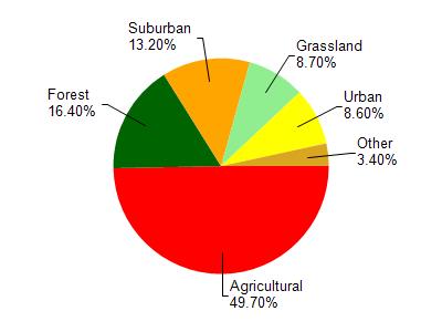
Lake Koshkonong is located in the Rock River - Milton watershed which is 48.76 mi². Land use in the watershed is primarily agricultural (49.70%), forest (16.40%) and a mix of suburban (13.20%) and other uses (20.70%). This watershed has 31.74 stream miles, 123.56 lake acres and 290.20 wetland acres.
Nonpoint Source Characteristics
This watershed is ranked Low for runoff impacts on streams, Not Ranked for runoff impacts on lakes and High for runoff impacts on groundwater and therefore has an overall rank of High. This value can be used in ranking the watershed or individual waterbodies for grant funding under state and county programs.However, all waters are affected by diffuse pollutant sources regardless of initial water quality. Applications for specific runoff projects under state or county grant programs may be pursued. For more information, go to surface water program grants.