Jefferson, Waukesha
No
No
No
Fish and Aquatic Life
Overview
Rock River Water Quality Management Plan, Lower Rock River Appendix. WT-668-2002. South Central Region, WDNR.
Golden Lake is a spring-fed mesotrophic, or moderately productive, lake in Waukesha County that in the past supported a good warm water sport fishery. Nuisance aquatic weed growth has been a problem and water quality appears to have declined in the last few years due to agricultural runoff and ditching and drainage of nearby wetlands. The lake's north and south side have unsewered development. The lake has poor public access. Despite these problems, the lake supports outstanding wildlife habitat. WDNR has initiated the construction of a new public boat launch on Highway 18.
Date 2002
Author Aquatic Biologist
Historical Description
Source: 1963, Surface Water Resources of Waukesha County Golden Lake T7N, R17E, Sections 30 and 31 Surface Acres = 250, S.D.F. = 1.53, Maximum Depth = 46 feet.
A medium-sized lake in terminal moraine. A deep marsh on its northwest end (in Jefferson County) has been ditched and drainage is intermittently northwest from the lake to the marshland adjoining Goose Lake in Jefferson County. The lake is spring fed and has a generally sandy bottom and clear water. Largemouth bass, pan fish, northern pike and walleyes constitute the fishery. Weeds are a usep roblem on shallow shores and landowners frequently apply for improve ments in the form of dredging and sand blanketing. Public access is not available; however, resorts and boat liveries provide for some use. Extensive wetlands adjoining the northwest end of the lake provide some potential for waterfowl production and migration resting areas.
Date 1963
Author Surface Water Inventory Of Wisconsin
General Condition
Golden Lake (775900) was assessed during the 2016 listing cycle; total phosphorus and chlorophyll sample data were clearly below 2016 WisCALM listing thresholds for the Recreation use and Fish and Aquatic Life use. This water was also assessed for chlorides and sample data were clearly below 2016 WisCALM chronic and acute listing criteria for the Fish and Aquatic Life use. This water is meeting these designated uses and is not considered impaired.
Date 2015
Author Ashley Beranek
Condition
Wisconsin has over 84,000 miles of streams, 15,000 lakes and milllions of acres of wetlands. Assessing the condition of this vast amount of water is challenging. The state's water monitoring program uses a media-based, cross-program approach to analyze water condition. An updated monitoring strategy (2015-2020) is now available. Compliance with Clean Water Act fishable, swimmable standards are located in the Executive Summary of Water Condition in 2018. See also the 'monitoring and projects' tab.
Reports
Recommendations
Lake Classification
Jefferson County Land and Water Conservation Department will undertake a lake classification process. The resulting lake classification system will enable the County and other lake management entities to implement appropriate lake management strategies in a priority -driven and efficient manner. It will result in the protection and restoration of the water quality and natural ecosystems of the lakes in Jefferson County.
Management Goals
Wisconsin's Water Quality Standards provide qualitative and quantitative goals for waters that are protective of Fishable, Swimmable conditions [Learn more]. Waters that do not meet water quality standards are considered impaired and restoration actions are planned and carried out until the water is once again fishable and swimmable
Management goals can include creation or implementation of a Total Maximum Daily Load analysis, a Nine Key Element Plan, or other restoration work, education and outreach and more. If specific recommendations exist for this water, they will be displayed below online.
Monitoring
Monitoring the condition of a river, stream, or lake includes gathering physical, chemical, biological, and habitat data. Comprehensive studies often gather all these parameters in great detail, while lighter assessment events will involve sampling physical, chemical and biological data such as macroinvertebrates. Aquatic macroinvertebrates and fish communities integrate watershed or catchment condition, providing great insight into overall ecosystem health. Chemical and habitat parameters tell researchers more about human induced problems including contaminated runoff, point source dischargers, or habitat issues that foster or limit the potential of aquatic communities to thrive in a given area. Wisconsin's Water Monitoring Strategy was recenty updated.
Grants and Management Projects
| Project Name (Click for Details) | Year Started |
|---|
| GOLDEN LAKE ASSOCIATION, INC: 3 yrs EMW/CLP AIS Control for Golden Lake 2021-2023 | 2021 |
| GOLDEN LAKE ASSOCIATION, INC: Golden Lake Association, Inc. 2023 CBCW | 2023 |
| JEFFERSON CO LWCD: LCO-Jefferson County Lake Classification | 1999 |
| Fish Propagation Actions | 2001 |
| GOLDEN LAKE ASSOCIATION, INC: Golden Lake Association, Inc. 2024 CBCW | 2024 |
| GOLDEN LAKE ASSOCIATION, INC: 3 yrs EWM/CLP IPM Control for Golden Lake | 2018 |
| SOUTHEASTERN WISCONSIN REGIONAL PLANNING COM: SWE - Training, Education, and Networking for Deep Headwater Lakes of Walworth and Waukesha County | 2023 |
| GOLDEN LAKE ASSOCIATION, INC: Golden Lake Association, Inc. 2025 CBCW | 2025 |
| GOLDEN LAKE ASSOCIATION, INC: Golden Lake Association, Inc. 2018 CBCW | 2018 |
| GOLDEN LAKE ASSOCIATION, INC: Golden Lake Association, Inc. 2016-2017 AIS Grant | 2016 |
| GOLDEN LAKE ASSOCIATION, INC: Golden Lake Association, Inc. 2020 CBCW | 2020 |
| GOLDEN LAKE ASSOCIATION, INC: Golden Lake Association, Inc. 2022 CBCW | 2022 |
| GOLDEN LAKE ASSOCIATION, INC: Golden Lake Association, Inc. 2017 CBCW | 2017 |
| GOLDEN LAKE ASSOCIATION, INC: Golden Lake Association, Inc. 2021 CBCW | 2021 |
| GOLDEN LAKE ASSOCIATION, INC: Golden Lake Association, Inc 2019 CBCW | 2019 |
| GOLDEN LAKE ASSOCIATION, INC: 3 yrs EWM/CLP AIS Control for Golden Lake 2024-2026 | 2024 |
|
Monitoring Projects
| WBIC | Official Waterbody Name | Station ID | Station Name | Earliest Fieldwork Date | Latest Fieldwork Date | View Station | View Data |
|---|
| 775900 | Golden Lake | 10007207 | Golden Lake | 3/25/1948 | 3/14/2025 | Map | Data |
| 775900 | Golden Lake | 683123 | Golden Lake - Deep Hole | 9/17/1973 | 6/22/2026 | Map | Data |
| 775900 | Golden Lake | 10017474 | Golden Lake -- Access | 9/3/2004 | 6/25/2026 | Map | Data |
|
Watershed Characteristics
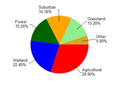
Golden Lake is located in the Bark River watershed which is 185.84 mi². Land use in the watershed is primarily agricultural (29.90%), wetland (22.40%) and a mix of forest (15.20%) and other uses (32.50%). This watershed has 265.69 stream miles, 3,499.26 lake acres and 22,145.94 wetland acres.
Nonpoint Source Characteristics
This watershed is ranked Medium for runoff impacts on streams, High for runoff impacts on lakes and High for runoff impacts on groundwater and therefore has an overall rank of High. This value can be used in ranking the watershed or individual waterbodies for grant funding under state and county programs.However, all waters are affected by diffuse pollutant sources regardless of initial water quality. Applications for specific runoff projects under state or county grant programs may be pursued. For more information, go to surface water program grants.