Marathon
No
No
Yes
Fish and Aquatic Life
Overview
The Big Eau Pleine River is classified as a warm water game fishery. The stream suffers from sedimentation and turbidity problems due to excessive run-off in the watershed. High bacteria counts at two county parks have forced swimming beaches to close. We have not determined the sources of the high bacteria, but potential sources include swimmers, septic systems, or animal waste. The Big Eau Pleine River is listed on the EPA 303 (d) list as an impaired waterbody for low dissolved oxygen and high levels of bacteria.
Kreitlow, James D. 1991. Upper Wisconsin River Central Sub-Basin Water Quality Management Plan. PUBL-WR-287-91-REV. Wisconsin Department of Natural Resources, Madison, WI.
Date 2002
Author Aquatic Biologist
Historical Description
The Big Eau Pleine River is classified as a warm water game fishery. The stream suffers from sedimentation and turbidity problems due to excessive run-off in the watershed. High bacteria counts at two county parks have forced swimming beaches to close. We have not determined the sources of the high bacteria, but potential sources include swimmers, septic systems, or animal waste. The Big Eau Pleine River is listed on the EPA 303 (d) list as an impaired waterbody for low dissolved oxygen and high levels of bacteria.
Kreitlow, James D. 1991. Upper Wisconsin River Central Sub-Basin Water Quality Management Plan. PUBL-WR-287-91-REV. Wisconsin Department of Natural Resources, Madison, WI.
Date 1991
Author Surface Water Inventory Of Wisconsin
Recommendations
Citizen-Based Stream Monitoring
The Big Eau Pleine Citizens Organization (BEPCO) proposes to upgrade its web site and financial management system to improve its outreach and capacity to implement projects for the betterment of the Big Eau Pleine Reservoir in Marathon County.
Shoreland Ordinance
Marathon County proposes to amend or create a shoreland zoning ordinance that complies with the requirements of NR 115, Wisconsin Administrative Code (as revised effective February 1, 2010) and retain existing regulations that exceed the water resource protections of NR 115 or are specific or unique to local needs.
Water Quality Planning
The Big Eau Pleine Citizens Organization proposes to collect data on agricultural practices within the Fenwood Creek watershed and initiate a dialogue with farmers and rural property owners for the purpose of working to reduce polluted run-off to the Big Eau Pleine Flowage in Marathon County. Major project elements to include:a) water quality monitoring and analysis, b) outreach events.
Monitor or Propose 303(d) Listing
Big Eau Pleine River - 1427200. The Big Eau Pleine Flowage is identified as an Impaired waterbody on the 303 d list. The flowage is located in Marathon County and > 70% of the watershed landuse is agriculture. Nutrient and sediment loading from the watershed causes severe summer algae blooms and contributes to low dissolved oxygen levels in the winter.
Nine Key Element Plan
Lower Big Eau Pleine River PWS Plan -Nine Key Element Plan - The Lower Big Eau Pleine River Priority Watershed Project plan assesses the nonpoint sources of pollution in the Lower Big Eau Pleine River Watershed and guides the implementation of nonpoint source control measures. These control measures are needed to meet specific water resource objectives for Lower Big Eau Pleine River and its tributaries. The purpose of this project is to reduce the amount of pollutants originating from nonpoint sources that reach surface water and groundwater within the Lower Big Eau Pleine River Priority Watershed Project area.
https://dnr.wi.gov/topic/nonpoint/documents/9kep/expired/LowerBigEauPleineRiver.pdf
Nine Key Element Plan
Upper Big Eau Pleine River PWS Plan - Nine Key Element Plan - The Upper Big Eau Pleine River Priority Watershed Project plan assesses the nonpoint sources of pollution in the Upper Big Eau Pleine River Watershed and guides the implementation of nonpoint source control measures. These control measures are needed to meet specific water resource objectives for the Upper Big Eau Pleine River and its tributaries. The purpose of this project is to reduce the amount of pollutants originating from nonpoint sources that reach surface water and groundwater within the Upper Big Eau Pleine River Priority Watershed Project area.
Monitor Fish Tissue
1427200 name Big Eau Pleine River TMDL ID 37 Start Mile 0 End Mile 16.6
Management Goals
Wisconsin's Water Quality Standards provide qualitative and quantitative goals for waters that are protective of Fishable, Swimmable conditions [Learn more]. Waters that do not meet water quality standards are considered impaired and restoration actions are planned and carried out until the water is once again fishable and swimmable
Management goals can include creation or implementation of a Total Maximum Daily Load analysis, a Nine Key Element Plan, or other restoration work, education and outreach and more. If specific recommendations exist for this water, they will be displayed below online.
Monitoring
Monitoring the condition of a river, stream, or lake includes gathering physical, chemical, biological, and habitat data. Comprehensive studies often gather all these parameters in great detail, while lighter assessment events will involve sampling physical, chemical and biological data such as macroinvertebrates. Aquatic macroinvertebrates and fish communities integrate watershed or catchment condition, providing great insight into overall ecosystem health. Chemical and habitat parameters tell researchers more about human induced problems including contaminated runoff, point source dischargers, or habitat issues that foster or limit the potential of aquatic communities to thrive in a given area. Wisconsin's Water Monitoring Strategy was recenty updated.
Grants and Management Projects
Monitoring Projects
| WBIC | Official Waterbody Name | Station ID | Station Name | Earliest Fieldwork Date | Latest Fieldwork Date | View Station | View Data |
|---|
| 1427400 | Big Eau Pleine Reservoir | 10044997 | Big Eau Pleine Flowage mile 5.5 upstream from Dam; mid channel near County Park | 8/6/2025 | 8/6/2025 | Map | Data |
| 1427400 | Big Eau Pleine Reservoir | 375010 | Big Eau Pleine River - Big Eau Pleine Reservoir | 11/10/2004 | 9/30/2017 | Map | Data |
| 1412200 | Lake Du Bay | 10030620 | Big Eau Pleine River - Tailwater below Big Eau Pleine Dam | 1/9/2006 | 6/20/2023 | Map | Data |
| 1427200 | Big Eau Pleine River | 375010 | Big Eau Pleine River - Big Eau Pleine Reservoir | 11/10/2004 | 9/30/2017 | Map | Data |
| 1427200 | Big Eau Pleine River | 10030620 | Big Eau Pleine River - Tailwater below Big Eau Pleine Dam | 1/9/2006 | 6/20/2023 | Map | Data |
| 1412200 | Lake Du Bay | 373455 | Eau Pleine Reservoir - Headwaters | | | Map | Data |
| 1427200 | Big Eau Pleine River | 10018359 | Big Eau Pleine River -- Access at Near Dam Road | 6/29/2011 | 8/16/2012 | Map | Data |
| 1427200 | Big Eau Pleine River | 10044997 | Big Eau Pleine Flowage mile 5.5 upstream from Dam; mid channel near County Park | 8/6/2025 | 8/6/2025 | Map | Data |
| 1427200 | Big Eau Pleine River | 373455 | Eau Pleine Reservoir - Headwaters | | | Map | Data |
| 1412200 | Lake Du Bay | 10018359 | Big Eau Pleine River -- Access at Near Dam Road | 6/29/2011 | 8/16/2012 | Map | Data |
|
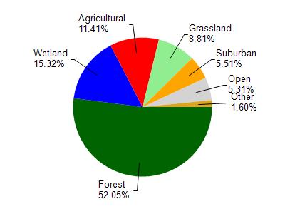
Watershed Characteristics
Big Eau Pleine River is located in the Mosinee Flowage watershed which is 81.83 mi². Land use in the watershed is primarily forest (52%), wetland (15.30%) and a mix of agricultural (11.40%) and other uses (21.20%). This watershed has stream miles, lake acres and 7,457.82 wetland acres.
Nonpoint Source Characteristics
This watershed is ranked Medium for runoff impacts on streams, Low for runoff impacts on lakes and High for runoff impacts on groundwater and therefore has an overall rank of High. This value can be used in ranking the watershed or individual waterbodies for grant funding under state and county programs.However, all waters are affected by diffuse pollutant sources regardless of initial water quality. Applications for specific runoff projects under state or county grant programs may be pursued. For more information, go to surface water program grants.